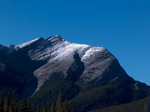
Overview
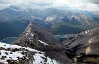
Rimwall is easily scrambled in an afternoon. The name Rimwall is a local one for this offically unnamed peak. Its proximity to Canmore make it a good training hike. The trail head is about a 25 minute drive from downtown Canmore by following the Spray lakes Road. You will see all levels of hikers on the normal route (4-5 hours round trip). This is a very scenic scramble/hike. With outstanding views of the backside of the Three Sisters to the north, a smaller summit called Miner peak, Lady Macdonald, the town of Canmore, Grotto Mtn. Mount Lougheed and the Spray Lakes behind you to the west. The route for this summit is found in Alan Kane’s
Scrambles in the Canadian Rockies which is a worthwhile purchase.
Getting There
Head out of Canmore on the Smith-Dorrien/Spray Lakes road past the Grassi Lakes and the Goat Creek day use parking. Continue on the unpaved Spray lakes road for about 22km out of Canmore. 4-5km passsed the dam you will see a sign for Spurling Creek.
Note July 4, 2005 there was a trail closure in effect due to bear activity. It is wise to check with the Trail centre at the Alpine Club of Canada or in Kananaskis for trail closures before heading out for this or any route in the area A small parking area is to the right just before the sign. You will find the trail head on the other side of the road. Begin by following the obvious trail through the woods to the left of the creek bed. About 20 minutes into the hike you will see some red ribbons on the left. You should turn left here. If you go straight and miss this you will be heading to West Wind Pass.
You can do the pass and turn left and follow the ridge but it will be a much longer day. Continue upwards on solid ground with switchbacks following where the ribbons lead you to a dry drainage area. Cross over this towards a cliff band and following a fairly visable trail gain the ridge. Follow this ridge to the col. Turn left and follow a gentle summit ridge to a series of small scrambles. The route here is obvious as there is extreme exposure on the right and a gentler slope on the left. Follow the ridge just to the left of the drop off. Just before the summit you will encounter a more difficult clift band. At this point decend about 50 yards to a visable break in the band. This is an easy scramble to gain the last ridge and an easy walk back up to the summit. First hour in the woods the next on fairly solid scree up to the col. The rest is a ridge walk on fairly solid ground with a couple of scrambles.
Red Tape
No red tape. This is a 1/2 day trip.
When To Climb
The summer months would be the most popular. June to end of September.
Camping
There are campgrounds in the area if desired
Spray Lakes West Shore Campground has 50 sites (403) 591-7226
There is also the Alpine Club of Canada lodge with rooms and excellent facilities of 19$ CDN a night. The Alpine Club of Canada (403) 678-3200, ext 1
Mountain Conditions
Spray Lake Ranger Station. (403) 678-5533
Alberta Tourist Visitor Centre (403) 678-5277
The Alpine Club of Canada (403) 678-3200, ext 1
weather office or (403) 762-2088 for weather conditions

 18033 Hits
 79.04% Score
 10 Votes