
-
 9182 Hits
-
 78.27% Score
-
 9 Votes
|
|
Route |
|---|---|
|
|
35.24570°N / 106.4858°W |
|
|
Hiking, Scrambling |
|
|
Spring, Summer, Fall, Winter |
|
|
Half a day |
|
|
Class 2/3 |
|
|
Overview
This route is probably the most straightforward way to climb the mountain as the other possible routes are blocked either by extremely long bushwhacking approaches, or prohibited by private or Indian Reservation land. Because of its conical shape, Point 8300 looks as if you could climb up any side of it, but the northwest has summit cliffs that are fairly tall, and the summit is capped by a small ridge of rock. The easiest way to the top is via the northeast ridge and a surprisingly hard scramble.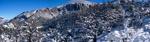
View North from the Saddle of Rincon Ridge
Approach
From the Piedra Lisa Trailhead (see Point 8300 main page for directions to the Trailhead) hike straight across the road to the new rerouted trailhead. There is a well-defined a marker for the actual trail heading up and to the north. Stay on this main trail all the way to the saddle, avoiding any temptations to take spur trails that head off right and to the east (the main two are the Movie Trail and the Waterfall Trail, both of which are unmarked). The total mileage from the trailhead to the post at the saddle is approximately 3 miles.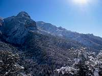
The Needle From Near Rincon Ridge

Rock Gendarmes on the Ridge
Along the way you will have astounding views of the most spectacular parts of the Sandia Mountains to the east. The Needle and the Prow will be prominent at first, and the large rock face of the Shield will take over as you gain the ridge. From the trail you will also be able to see various gendarmes of rock peppering the ridge. Point 8300 is clearly visible to the left of two prominent rock walls. You will know when you have gained Rincon Ridge when you reach the pole that marks the trail, and when you can see to the north down into Cañon del Agua.
Route Description

The Pole at the Saddle

This is the First Cliff Fin

The Backside of the Cliff Fin

The Second Cliff

Another Peak to the North of Rincon Ridge

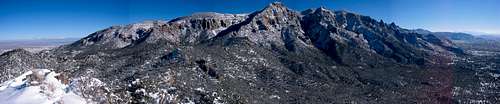
The Summit Ridge
From the pole, head left (west) along a faint trail as it follows the ridge. After about a quarter of a mile, you will come to the ridge top with a view to the first cliff band or fin that you have to traverse around. You will be looking at the top of the fin,and you will need to head down and to the right (north) to circumnavigate the cliff. Alternatively, you can climb up and over the rock fin. It is an easy scramble in dry weather. Just be careful of all the loose gravel and drop-offs.
Once you reach the bottom of the north side of this fin, there will be a thicket of Gambel's Oaks. Head down and to the north (right) to avoid bushwhacking through these dense and nasty bushes. Once below the thicket, head up and to the left (south) until you once again gain the ridge. There may be a faint trail and pink surveyor's tape marking the pseudo-trail. Once on the ridge, you will gain a view of the east side of the next cliff.
Stay on the ridge and to your right, weaving in and out of the trees. Cresting a rise, you should be able to see Point 8300 rising ahead of you through the trees. Head directly towards it. Once the ground starts to rise again you will not be able to see the summit. Just keep heading up and slightly to your left as you ascend the northeast ridge.
As the terrain steepens, rocks will start taking over. You will need to ascend some ledges and thrash through a few pine trees as you gain the final summit ridge. There is a bit of surprise exposure as you notice the summit cliffs on your right, and the rock ledges you have ascended on your left. The moves are not hard, but there are a couple class 2 scrambles that border on class 3 due to the exposure. In winter it may be wise to have an ice axe.
The summit is rewarding and spectacular with views of the Rio Grande Valley, the Sandias, the Rincon Spur Ridge and Rincon Peak, the Jemez Mountains to the northwest, the Sierra Ladrones to the southwest, the Manzano Mountains to the south, and Cabezon Peak and Mount Taylor to the west. Return the way you came.
Essential Gear
Bring plenty of water (especially during the heat of summer).A map and compass may be helpful for the bushwhacking on Rincon Ridge, but if you stay on the ridge as much as possible, Point 8300 is pretty easy to find.
During the winter, consider snowshoes for Rincon Ridge, and an ice axe for the final summit ridge if snow is present.
Great Summit Views!