
-
 3820 Hits
-
 71.06% Score
-
 1 Votes
|
|
Route |
|---|---|
|
|
46.43064°N / 13.51284°E |
|
|
Skiing |
|
|
Spring |
|
|
Half a day |
|
|
Medium |
|
|
Rating The Tour (By Hiking Standards)
0. General. 833 m to 2240 m, exposition East. Long flat valley (road), ideal ski slopes just till under the notch, steep, narrow couloir (50 m) on the notch. Gear: Tour skiing equipment, ice pick, crampons, helmet.
1. Effort. 1420 m, 4 h for ascent, 1:30 h for skiing.
2. Power. 3 - medium (couloir of some 40 degrees).
3. Psyche. 3 - medium (steep final part, big danger of falling stones from the neighbouring walls).
4. Orientation. 2 - easy (almost no dilemmas on the terrain).
Overview
The end part of Valle di Riofreddo / Dolina Mrzle vode is one of the most beautiful ski tours in Viš and Montaž group. Unfortunately the approach through Riofreddo valley is long - the road into the valley is closed for public traffic at the very beginning. But the scenery of the valley, not many visitors and the interesting, but hard final part of the tour will pay off all inconveniences.
Route Description
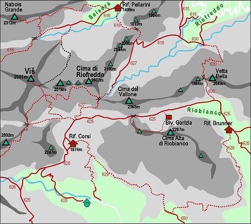 A self-made map of Cima di Riofreddo / Divja Koza and its routes
In Valle di Riofreddo

Upper part of the valley
We park in Riofreddo village, 833 m. From there we follow the road till the end of its more flat bottom part, on some 1025 m of altitude. From there we continue following the road, which now ascends in several turns towards the West. On some 1230 m the first marked path goes left, but that's not the right one (it goes on Forcella di Rio Bianco). We continue by the road till some 1315 m, where the path No. 618 goes left up. We follow it towards the West, ascending first over a plane slope. When we approach the valley step, we must overcome a steeper slope, covered with unpleasant (depends on snow conditions) beech woods. But the slope is soon over and on some 1450 m we reach the flat part of the upper valley. We comfortably continue towards the W-SW, approaching another steep barrier, which stretches across the whole valley. But in normal conditions we can also do this slope skinning up in many turns. Coming over, the slopes hardly get any less steep. Skinning up in many turns we gain altitude, also realising how the walls on both sides of the valley are squeezing us more and more. The scenery here is really stunning. On the right the wild towers of Cime Vergini (Virgins), on the left more than 550 m high northern walls of Cima del Vallone.

Couloir

On Forcella di Riofreddo
Depending on snow conditions we proceed skinning up in turns. If this is too hard, you might take your skis off, put them on the backpack and continue walking directly upwards. Now you are already in the couloir, but it is not very steep yet. With no major problems you reach the point, where the couloir seems to branch, although it is clearly evident that the right gorge is the main one (we see the left one finishing in rocks). There we usually leave skis. The upper 50 meters we have a steep and very narrow couloir, which does not promise skiing at all - or, only for the most stubborn ones. In good conditions we do this part with an ice pick or, if snow is hard, with crampons additionally. Steel ropes, which in summer help the ascent, are in winter and spring usually all covered with snow.
On Forcella di Riofreddo (notch) our tour usually finishes, climbing Cima di Riofreddo by ferrata Anita Goitan and over the South route is a very rare event among tour skiers (from the notch we have 2 hours in summer to the top!). So, we first carefully descend to our ski depot, do the upper steep part of the couloir and then choose the slopes, where conditions are best for skiing. The left part is more often on the sun, while the slopes on the right are in a permanent shadows of north walls. Reaching the altitude of 1500 m we should decide again. Keeping left (by the route of ascent) means shortening the real ski fun, as we shall soon reach the road. But we can also keep skiing right, under the northern walls of Vetta Bella. Over a steep and narrow passage we continue crossing fine, steep northern slopes, all the way down to some 1100 m of altitude, where we must finally turn left and hit the road. Now, nothing can help us at walking (or cross-country skiing) down through the long valley.