Getting There
I approached Burnt Peak from Lancaster and Lake Hughes. The area can also be approached from I-5 near Gorman and Highway 138. Take Pine Canyon Road from Lake Hughes west about 5 miles to the Bushnell Summit. Turn left on a dirt forest service road that is signed as 7N23. 7N23 parallels Pine Canyon Road for a couple hundred feet before turning more westerly. Follow this road for 2.1 miles as it climbs steeply up to the trailhead at elevation 5,240ft. As you reach the trailhead area, you enter a large flat area with plenty of parking. 7N23 continues to the right. 7N08 goes to the right and straight ahead is Burnt Peak and the access road to the summit. You can also get to the trailhead by using 7N08 or from finding the other end of 7N23 and driving up to the trailhead.
Route Description
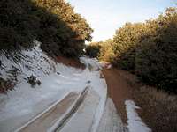
The route to the summit of Burnt Peak from the trailhead is easy to follow. Head west on the road that has a white gate blocking the way. You can see Burnt Peak ahead and it has some communications towers on the summit. Walk around the gate and follow the road. There are no short cuts or alternate paths. Stay on the main road as it descends about 250 ft to a saddle. The road then climbs up between Little Burnt Peak and Burnt Peak. Stay on the road all the way to the summit where you will see the FAA facility with the large flat area on the summit surrounded by a fence. I followed the fence all the way around the FAA facility and enjoyed the view in all directions
Essential Gear
When hiking, the ten essentials are always required. Since this is basically a road hike, no technical gear is required. Be sure to bring water in the summer. Take your camera and enjoy the views.
External Links

 3415 Hits
 0% Score
 0 Votes