
-
 9251 Hits
-
 83.1% Score
-
 16 Votes
|
|
Route |
|---|---|
|
|
45.20420°N / 7.07640°E |
|
|
Mountaineering, Scrambling |
|
|
Summer |
|
|
One to two days |
|
|
EE |
|
|
Rocciamelone Normal route from Malciaussia
Rocciamelone 3538 m a mountain belonging to the Graie Alps, Rocciamelone-Charbonnel Group and entirely located in Piedmont, between the Valle di Viù and the Val di Susa. Due to its altitude and its dominant position it is a mountain that enjoys an extraordinary panorama: on clear days the view from the summit is wonderful and really wide on the great mountains of the Western Alps, like Monte Bianco, Monviso, Gran Paradiso, Monte Rosa and Barre des Ecrine, as well as the nearest peaks of the area.

|
")
|
On the summit there are a famous bronze statue of the Madonna, a statue of Re Vittorio Emanuele II and the Refuge Santa Maria, a bivouac open with 13 beds owned by the "Giovane Montagna", a mountaineering association of Turin. Rocciamelone is a very popular mountain in reason of its wide panorama, its history and the ease of the standard route starting from La Riposa across the Rifugio Cà d'Asti. This route was the itinerary of the first climbers and on this page it will be described as the route of descent.
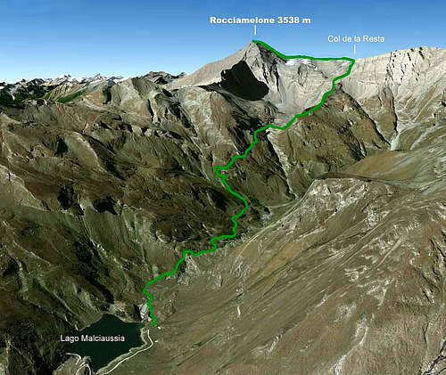
It will be described on this page the most interesting ascent itinerary starting from Lake Malciaussia in Valle Viù across the Rifugio Tazzetti, the Col de la Resta, the Rocciamelone Glacier and the North-West Ridge.
History

Rocciamelone is a mountain that has a very special place in the history of the alpine climbs. It's the first mountain of the Alps in chronogical order - and probably of the whole world - for which we have a certain first ascent and a name for the summiter. Already in the Middle Ages there were several attempts to climb to the summit, but without success. What's the reason for this strong interest towards Rocciamelone, absolutely much in advance if compared with the birth of mountaineering, which started in 1786, the year of the first ascent of the Monte Bianco? It is soon explained: Rocciamelone was mistakenly believed to be the highest summit of the Alps for centuries, probably because its majesty, its visibility from the Po Valley, the enormous height gain above the ancient roman city of Susa. On Sept 1st, 1358 the local nobleman Bonifacio Rotario D'Asti managed to climb the summit with a small metal image of the Holy Virgin. Captured by the Turks during the Crusades, Bonifacio Rotario had pronounced a vow to the Madonna, committing himself to dedicate a simulacrum on the summit of the first mountain he had seen if he had managed to come back and save in Italy.
Getting there
From Turin, drive to the North towards Lanzo, but before you reach this town you have to turn towards the Val di Viu' (the more southern of the three Valli di Lanzo). Drive to the end of the road (open only without snow), up to the power plant dam, and reach the Malciaussia lake 1805 m
Approach to Rifugio Tazzetti
Take the dirt road that runs along the northern bank of the lake, passing next to the "grange di Pietramorta". Cross the tributary of the lake on a bridge and immediately come across a fork: on the left there is the path leading to the Colle della Croce di Ferro, on the right the approach to Rifugio Tazzetti continues. Between meadows and ups and downs, the trail continues along the lake shore and then enters the valley of the Rio Medagliere. After crossing the stream, the trail climbs up to the base of the NE crest of the Brillet, then diagonally across the small gorge where it flows the Rio Rumour. After a stony, the shelter begins to appear. After crossing a ford, the path rises with steep bends to the plateau where it's located the Rifugio Ernesto Tazzetti 2642 m, owned by the subsection CAI Chieri, where you can stay overnight and divide the route in two days.

Route Description
Rocciamelone from Malciaussia across the Glacier and the NW ridge
Summit altitude: 3538 m
Difficulty: Alpine F
Difference in level: 900 m from Rifugio Tazzetti
Behind the shelter, take the marked trail that goes up the slope above it to the west, reaching the ridge coming from Colle della Resta. Following the signs we continue keeping almost always under the ridge and reaching a castle of clear rocks, which are avoided on the left climbing easier rocks. Continue to a shelf with some crosses, where you climb to the right following the trail that leads to cross a stream. Here begins a slope of cliffs with schist rocks interspersed by ledges and terraces. Go up along the steep left bank of the river and heading to the metal cross you reach the Col della Resta 3260 m.

|

|
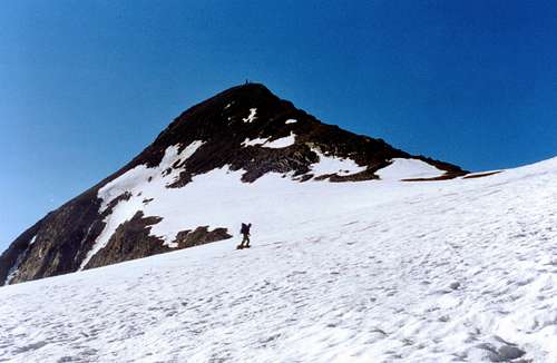
You descend on the semi-flat edge of the Glacier de Rochemelon, in strong decline, from where the North-West ridge that will lead us to the summit is clearly visible. Follow the non-crevassed glacier in the south-west direction, along a small ephemeral lake and aiming at the depression located at the base of the ridge.

|

|
After a flat stretch you climb the fine ridge along the wire up to the statue of the Madonna on the top. We descend to the underlying chapel-bivouac, from where we take the descent to the Val di Susa side, the itinerary of the first ascent.

|

|
After a steeper section equipped with ropes and rails, continue down along the southern slope of the mountain, reaching the Rifugio Cà d'Asti 2854 m in about an hour from the top. After passing the shelter, take the steep but well marked trail that runs along the SE side of Rocciamelone and after having traversed it for a long time it joins the GTA (Grande Traversata delle Alpi) trail. You soon rise to the hill of the Croce di Ferro 2558 m from where you follow down the path that comes back to the lake of Malciaussia thus completing the ring.

|

|
Essential Gear
Normal mountaineering gear (taking into account for the cold weather at altitude), crampons and ice-axe on the glacier are useful.
Red Tape
No fees no permits required
Huts
- Rifugio Tazzetti
- Rifugio Cà d'Asti
- Rifugio Santa Maria, an emergency shelter on the summit with 25 beds

|

|

|
When to climb
The best season to climb Rocciamelone is during the summer, specially July and August. In the other periods it's possible to find snow or ice on the itinerary: in this case difficulties can increase.
Meteo
Guidebooks and maps
"Alpi Graie Meridionali", published by Club Alpino Italiano (1980) in the Collana "Guide dei Monti d'Italia" with full descriptions, photos, etc.