
-
 8843 Hits
-
 81.74% Score
-
 14 Votes
|
|
Mountain/Rock |
|---|---|
|
|
48.10168°N / 90.47257°W |
|
|
Cook |
|
|
1900 ft / 579 m |
|
|
Overview - Vast Wilderness, Beautiful Views, Tough Hiking...
...in the Midwest US. I have been rescued from city life time and again by Minnesota's 'North Shore', the part of the state that stretches across the north shore of Lake Superior to Canada. It is a dense collection of forest, low lying but tough mountains, waterfalls and canyons. Lately I have been exploring further north and inland to the vast Boundary Waters Canoe Area Wilderness (BWCAW), one million acres of interconnected lakes, dense forest ... and a few wonderful trails.
One such trail in the BWCAW is the Caribou Rock trail, which has regularly pounded me into the ground physically and mentally each time I have tried it. But each time I am drawn back and go a bit further because there is still more to see. The Rose Cliffs, six miles from the trail head, are a beautiful destination, but do not underestimate the challenge of this hike.
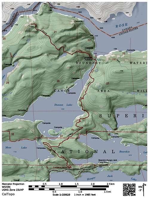
The Rose Cliffs are an iconic part of the Border Route Trail, a 65-mile long hiking trail that crosses the Boundary Waters Canoe Area Wilderness. The Border Route follows the string of beautiful lakes that line the international border between the USA and Canada.
The Caribou Rock Trail offers access into the BWCAW and the Border Route trail for day hiking. Due to the deep woods that line this route, overlooks of any kind are precious, and the Rose Cliffs offer 4 tightly spaced rock platforms overlooking some of the stunning border lakes in the area.
But this trail, a 12 mile round trip day hike, will test you.
The trail goes up and down. A lot. On mapping software I am seeing estimates of at least 1700 feet gain and 1500 feet lost one way. So repeat that up/down drill in reverse on your way back.
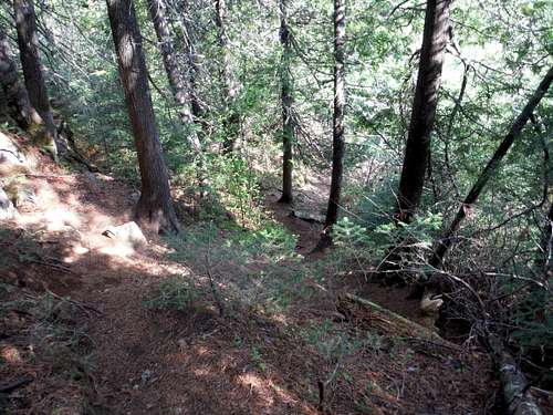
The trail is mostly easy to follow, but there are a few sections that you need to keep your eyes peeled. You need to be comfortable route finding in deep woods in a couple of places – and you do not want to be doing that at dusk or in the dark. There are no cairns, only a few signs and some flagging on this route (and take the flagging with a grain of salt).
The Route
The Boundary Waters (and their Canadian counterpart Quetico Provincial Park) are Shangri-La to the canoe enthusiast – and this route can be done with canoe from a number of places. However, since I am not a canoeist, I had to rely on one of the few access points inland into the Border Route: The Caribou Rock Trail.
The Caribou Rock trail gives up two wonderful overlooks of Bearskin and Moss Lakes within 0.75 mile of the trailhead, and for some people this may make a fine outing if you only have an hour or two.
But for those who wish to go further, once past these viewpoints the trail stays firmly in the woods and gets seriously into its wilderness role.
After some steep downhill sections...
...travel across a surprisingly boulder choked creek. Then in short order the portage between Bearskin and Duncan Lakes will cross your trail. Ignore the portage routes and find the Caribou Rock trail heading north which resumes across the portage, though there is a small jog to the east.
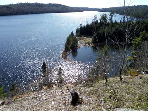
After a stiff climb you will head west sharply toward Duncan Lake, and get some nice lake views in places. But Duncan is a large lake, and when you start thinking that you are putting the lake in your rear-view mirror, you will find it is just getting started.
You will catch the lake at various times as you head north, and some serious up and down hiking ensues. Here and there the trail can be less discernible between the rocks, roots and deadfall. Take a good look at those spots so coming back you can recognize the sketchier sections on your way back.
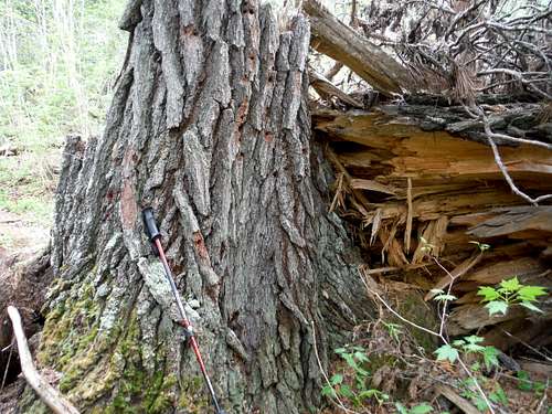
As you get further down the trail, you will see dramatic evidence of the ‘Big Blow’, the 1999 derecho that brought down 25 million trees in the Boundary Waters Canoe Area Wilderness. The 90 mile per hour straight line winds snapped some trees like matchsticks, and it took a large scale effort to reopen this trail.
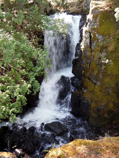
After several sets of up/downs, Duncan Lake will end, and will begin pouring into a creek that will result in Rose Falls before it empties into Rose Lake to the North. This area can be confusing, and it is easy to get disoriented.
Your trail (Caribou Rock Trail) runs north (south going back) to the east of the creek. You can take the Border Route East from there.
A portage from Duncan Lake to Rose Lake (The Stairway Portage) runs twisting north/south to the west of the creek. You can catch the border route west from the stairway portage.
The only convenient connection between the two north/south routes is the small bridge that crosses the stream shortly before the falls.
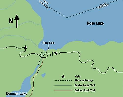
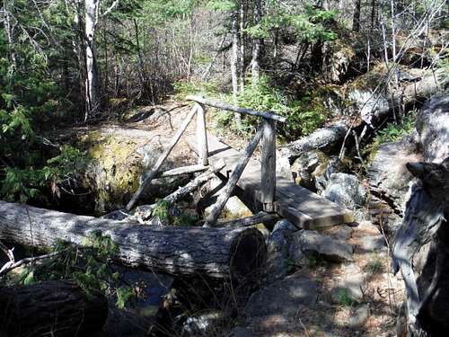
Before heading west on the Border route to the Rose cliffs, cross the bridge head down 28 steps of the Stairway portage and check out lovely Rose Falls. When done return up the 28 steps and take the Border Route trail west.
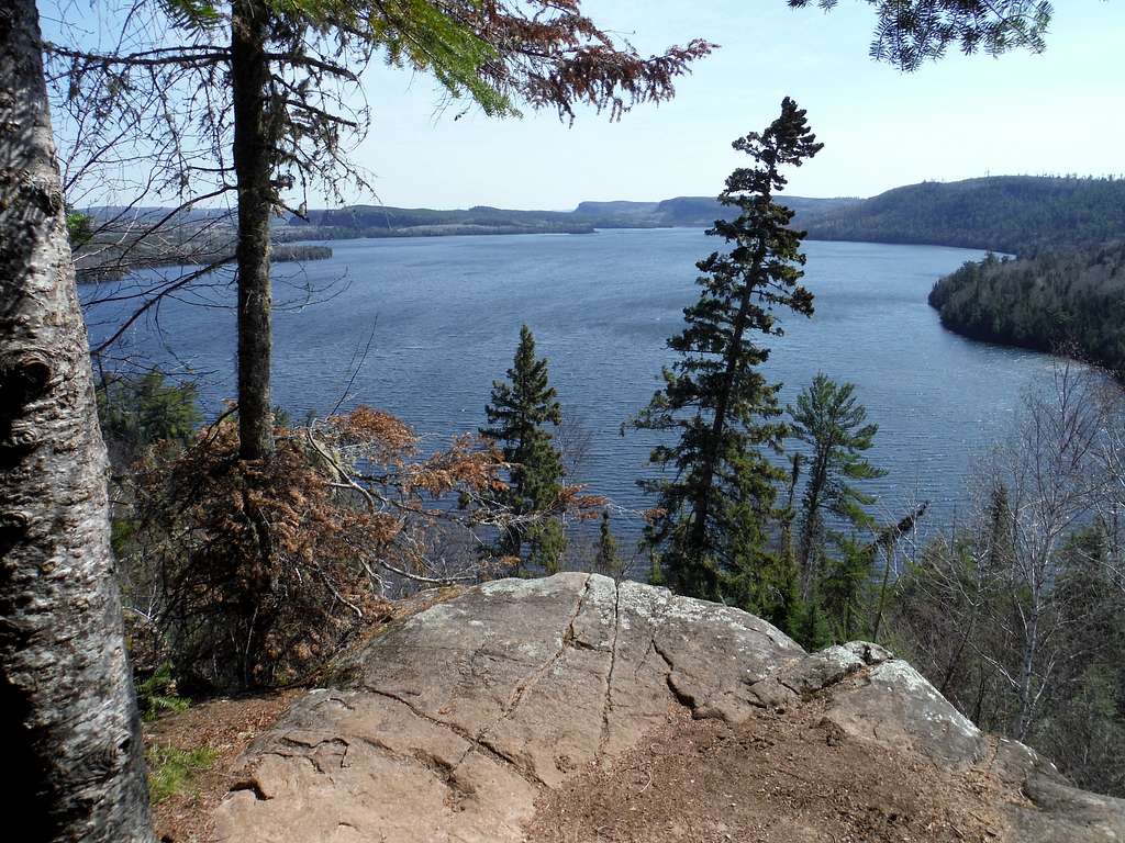
You still have 2 miles west along the Border Route to the Rose Cliffs. The good news is that within a short distance of the falls going west there is a stunningly beautiful overlook view over Rose Lake and into Canada. It is breathtaking. This is a good place to check your energy levels, and turning back here is a fine outing.
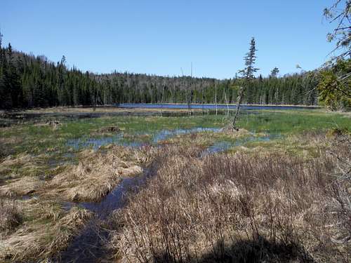
The bad news is that to see the Rose Cliffs, more up and down hiking commences, a notch less extreme than what you have been through, and the trail is mostly discernible. You will soon walk up to a small lake (or large pond) tucked into a plateau. Later you will climb above it for another great view. Keep your eyes out for moose.
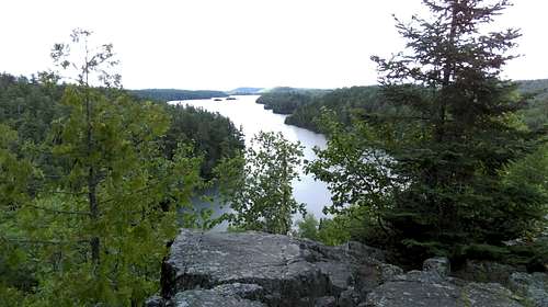
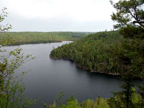
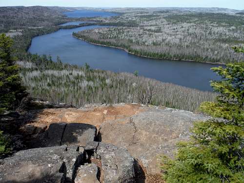
You will be solidly in the forest now until the Rose Cliff area, more than a mile away. When the first (eastern-most) overlook appears, it will be obvious and right off the trail, taking your breath away. Rose Lake is below you, Rat Lake and South Lake are seen to the West North West. The Canadian border is halfway across the lakes.
Overlooks are rare enough on the Border Route that each one is celebrated. The second overlook is close by and also obvious from the trail, with stadium seating for the great views.
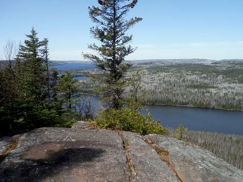
Still going west, the next two overlooks are easy to miss (I know, I missed them and walked more than three quarters of a mile further west thinking they would be just as obvious as the first two). They are not too far away west from the first two, but are accessed with 2 separate faint use trail spurs to the right. If you are looking carefully you should find both, which my require a bit of rock clambering and bush whacking. But when you find them, you will rejoice at the views, now including the cliffs themselves.
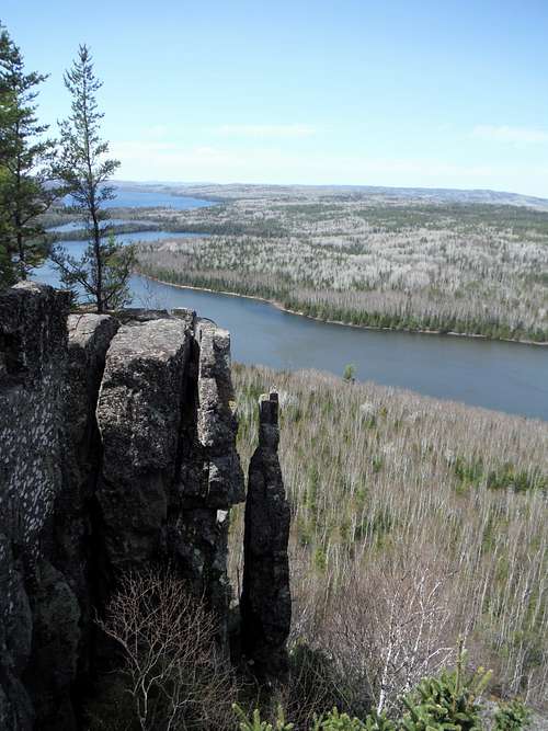
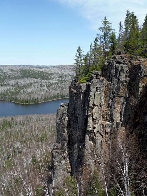
The view of the pinnacle from near the third overlook is a Border Route icon. The pinnacle rises just below the fourth overlook, and you have to walk to the edge of that overlook to see it, you do not even know it is there on the top of the fourth overlook.
These cliffs are not technically a summit, but they feel like one.
OK – now all that needs happen is to get back. At this point I felt I had energy to spare It was quickly squeezed out of me with the higher temperatures of mid afternoon and the relentless up and down, repeated. Up 1500 and down 1700 or so. I was a shambling wreck by the time I got back to the trailhead.
Getting There
From the beautiful Lake Superior town of Grand Marais (2 hours northeast of Duluth), take the Gunflint Trail (County Route 12) north about 30 miles. Turn right at Hungry Jack Road (County Rd 65), staying on the main gravel road about 2 miles until you see the well signed trailhead on left. Parking on right for about 6 cars.
Red Tape
The BWCAW has you fill out a free permit at the trailhead.
Other Options
There is an overlook near the Rose Falls going east on the Border Route within a quarter mile or so.
A long loop hike is possible due to a new trail along the south side of Moss Lake, and the South Lake trail - I do not know the quality of these trails.
Can you try this in winter? Yes, you can try. I did, on showshoes. I did not get far. I made it past the portage but never saw Duncan Lake.
Camping
There are many designated campsites within a few miles of the Rose Cliffs, but few are foot accessible ecxept two at Partridge Lake. Consult the BWCAW website Boundary Waters Canoe Area Wilderness
Resources
Please get a good map of the area, do not rely on this write-up. Voyageur Maps is a good one (map 9). Though a canoers map, it shows the trail system well, and shows designated campsites.
Border Route Trail: Border Route Their trail guide (Marcia Scott and Chuck Hoffman) is excellent.
Great book on area hikes: Hiking the North Shore by Andrew Slade North Shore Hiking