
-
 17605 Hits
-
 85.87% Score
-
 21 Votes
|
|
Mountain/Rock |
|---|---|
|
|
49.82000°N / 7.83000°E |
|
|
1072 ft / 327 m |
|
|
Overview
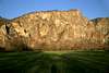
 Bastei and Glockengrat seen from the vineyards beneath Rotenfels Bastei and Glockengrat seen from the vineyards beneath Rotenfels |
Rotenfels is supposed to be Germany's highest and largest rock cliff north of the Alps (whatever that means and ifever this is correct). It rises out of Rheinhessen's smooth hillcountry by 220 near vertical meters and shows its red south face towards the twin town of Bad Münster am Stein / Ebernburg. The rock is composed of porphyry formations which account for its red colour. They have been eaten away by erosion to form Dolomite-like rock formations, albeit on a comparatively tiny scale.
Rotenfels is located at the junction of the Alsenz- and Nahe rivers a little west of Bad Münster am Stein / Ebernburg. The Nahe River has been forced to eat its way through the rock in order to clear its way to its end at Bingen where it flows into the Rhine River. The Nahe knows a couple of these "breakthroughs" but none is as impressive as the one at Bad Münster am Stein. In the west there is Rotenfels with its massive circular wall, clearly eaten away by Nahe River - in the east there are the slightly lower but not less impressive walls of Gans (= Goose) and Rheingrafenstein the latter of which carries the ruins of a medivial castle (not the only one as you will see below).
The region itself is known for its thermal-, salt- and radium-/radon-baths. You can tell by the town names which always start with "Bad" (= Bath): Bad Kreuznach, Bad Münster, Bad Sobernheim. Also the region is renowned for their "Gradierwerke" / Salines, long walls over which the "salty" water flows to clean the surrounding air for the spa-visitors. There are a lot of these walls between Bad Münster and Bad Kreuznach.
(Note aside: I have long been envious of all you SP-members who only have to drop out of their back yard to start climbing the most beautiful mountains. This - in my humble opinion - is utterly unfair; my backcountry just offers - hills. The single one formation that can apply for SP-submission is Rotenfels and so I have been determined to post is ever since I joined in November 2003). And thus I'll try to do my very best.)
 |  |  |  |  |
Getting There
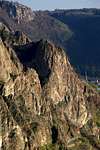
 Götzenfels and Rotenfels seen from the entry to the Götzenfels Ridge Route
To quote Tim Logan (speaking of Baffin Island): “this is the most difficult part of the journey“, at least for non-locals. Though Rotenfels is only some 60km /40 miles) away from central Europe’s largest airport in Frankfurt the task of getting there can be quite challenging. Germany's Rhein-Main area is a very densely populated place, you have a lot of possibilities to get to Bad Münster am Stein, especially by car.
But: there are so many motorways that you most likely will be lost. Let us assume that you arrive by plane at Frankfurt's Rhein Main Airport. First, the easy part:
By train:
There are regular trains (every other hour I have been told) from Frankfurt to Bad Kreuznach and onward to Bad Münster am Stein. These trains are called "Bummelzüge" which in a literal translation means "Dawdling-Trains". If you take faster trains from Frankfurt you will have to change at Mainz. If you do so, give me a call, cause that’s where I live.
By car:
If you happen to have a GPS-navigation system on board just type in Traisen / Rotenfels and the young lady will lead you directly on top of the rock. If you are not among the lucky ones, do this:
Take Motorway A3 westward (direction Köln/Cologne) until intersection Mönchhof (Mönchhofdreieck). There get of on A67 south direction Darmstadt until you get to the intersection with A60 at Rüsselsheim (Rüsselsheimer Dreieck). Now follow A60 until its end at the intersection with A61 at Bingen (Dreieck Nahetal). You have to take A61 southward (direction Ludwigshafen) but have to get off at the next possible exit on B41, direction Bad Kreuznach. Don't drive into Bad Kreuznach (though this might be interesting as well but follow B41 around the city and leave at the exit Bad Münster/Norheim/Stromberg. After some 3km (2miles) there are two roundabouts at the second of which you get the first (brown) sign towards Rotenfels. Now follow the signs - you can either get to the top (at Traisen turn off the main road and get through the village and onto Rotenfels by a side road) or to the base by following the road to the Nahe river at Norheim, then turn right in the direction of Bad Münster am Stein. This road will take you along the base of Rotenfels and is certainly a Must, while driving in the area. Find a parking lot in Bad Münster (there will be a parking fee) and hike back towards the rock.
If you want to visit the rocks on the other (southern) side of the river Nahe get to the river in the center of town and take the ferry (1€ per adult) to the other side. The ferry is operated manually - the ferryman uses the chain across the river to manually drag you to the other side.
 |  |  |  |  |
Climbing Rotenfels
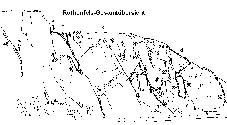
The picture above was linked to the German Climbing Guide by Jörg Brutscher.
There are quite a lot of routes (almost 50) on Rotenfels but the quality of the rock is highly questionable. The routes vary from II+ to VII in difficulty, several of the routes are not recommended and some are even closed. Take a look at the Climbing Guide which unfortunately for most of you is in German. Routes that are described there in bold letters are recommendable, the ones in italics are closed and the ones with regular types are not to be recommended. Unfortunately the highest wall – Bastei – belongs to these. See the red tape section for restrictions in climbing the rock.
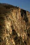
 Rotenfels seen from the west on a warm winter day sunset
A great page with interesting climbing pictures is:

www.on-sight.de
 |  |  |  |  |
Red Tape
 Male sand lizard, Lacerta agilis
This is one of the few places where there actually is red tape. Unfortunately climbing Rotenfels is restricted. The reason is that directly below the rock there is the road between Bad Kreuznach and Bad Sobernheim (as well as the train track). The rock is very fragile and so climbing is allowed only at certain times of the year. Certain routes are completely closed.
West of "Glockengrat" climbing is restricted all year round; east of it closed between January 1st. to June 30th because of peregrin falcon breeding. Furthermore there is an all-season blockage of various routes due to the proximity to the road. Rotenfels is a protected area/nature monument! Please don't take or leave anything!
For the hard boiled nature lovers: here is the german document declaring the rock natural monument
Parking is free on top of the rock as well as in Traisen, Norheim and Ebernburg. Bad Münster - like any recreational spa - demands hefty parking fees.
 |  |  |  |  |
Other Outdoor Activities
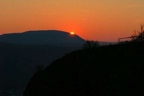 The sun setting across the Nahe River above the Glockengrat Ridge
Besides the hike/climb onto Rotenfels or Rheingrafenstein the area offers a couple of other interesting outdoor activities:
Biking
There is the "Nahe-Radwanderweg" a 100km long biking trail along and above the Nahe river. The region around Rotenfels is the most beautiful part of the whole route but there are other very worthwhile areas (at Bingen or Idar Oberstein at both respective ends). Be prepared to go short distances: the Nahe region is one of Germany's major wine growing regions (if you look closely you will see it on the pictures). Take your time and taste the wine (preferably the white one!).
Draisine Tours
Anybody knows what a draisine is? It is one of these manually propelled vehicles on rail tracks. The old trail track in the Glan river valley - some 15km west of Rotenfels has been converted into a draisine track. No regular trains run there anymore, only you and your fellows pedalling one of the heavy draisines in either direction.
Paragliding
Well, yes, this is not the most typical destination for paragliders. But - like the climbing rocks - it's a nice training location. Plus - there are lots of fields in which you can land. Paragliding clubs at Oberhausen and Weiler.
Hiking
There are a lot of marked hiking trails in the region. The most beautiful ones run through the vineyards above the Nahe river. As said in the biking subsection - take your time and enjoy the wine. Many of the vintners offer accommodation (mostly apartments).
 |  |  |
History, Castles, etc
For all of you who are SP-members for the climbing only: skip this section. But I'm the son of two teachers and it seems to be in my genes to lecture a little:Both the city of Bad Kreuznach and the town of Bad Münster am Stein have been known since Roman times. In both locations the Romans stayed for some 450 years. As usual they found out about the baths and their healthy environment and just stayed there. Thus the region is one of Germany's (and consequently Europe's) oldest historical regions. A lot of history and culture (= bloodshed) has taken place here.
There are three medevial castles in the direct vicinity of Rotenfels: Ebernburg, Altenbaumburg and Rheingrafenstein. All have been destroyed by french troops during the invasion by Louis XIV into the region - like so many castles on the Rhine. Some - like Ebernburg have been restored but most of the castles still lie in ruins.
Ebernburg
First documented in 1212. It changed owner quite often before coming to the clan of Sickingen in the 15th century. Belonged to Franz von Sickingen (1481 - 1523) who - taking part in the reformation - used it for conclaves with like-minded people. (Anyone read Goethes "Goetz von Berlichingen"? Sickingen has an important role in that drama).
Altenbaumburg
First mentioned in 1129. Destroyed in 1689. Still in ruins but an extensive castle topography. Main house (Pallas) has been resurrected
Rheingrafenstein
See section below
 |  |  |  |
Rheingrafenstein
The castle was erected in the 11th century on a rock high above the Nahe river. Destroyed in 1688/89. Commanding view of the Nahe river valley. A popular destination for hikers and climbers. Look at the pictures to see why. |  |  |  |  |
When To Climb
This definitely is a all year round location. The ferry to Rheingrafenstein might be closed but a hike of half an hour will take you to the other side of the Nahe River across the bridges. No special gear needed.Of course if you want to climb the southern faces of Rotenfels, always carry a helmet! The rock is very fragile and tourists and kids above can induce rockfall.
 |  |
Accommodation
There are lots of hotels in Bad Münster am Stein / Ebernburg. I would recommend, however - to escape the spa-"tourists" - to look for apartments with some vintner. This might be especially interesting during the harvest season. There is a campground directly below Rotenfels on the Alsenz shore at Ebernburg. Being of the same region I never tried to camp there so please don't ask me for specifics.Mountain Conditions
It really doesn't matter but lookup www.wetter.de (lookup Bad Kreuznach) for waether info on the region. You will be able to go to the top of Rotenfels in every weather. It was quite stormy when I took most of the pictures on April 3rd 2004.Book(s)
Actually there is only one book in which the routes on Rotenfels are described. It is a good addition to the Climbing Guide as referenced in the "Climbing Section" and vice versa. The Book isKletterführer Rhein Main Gebiet
Ch. Deinet
Panico Alpinverlag, 2002
ISBN: 3-926807-76-8
 |  |
External Links
- On Sight
Climbing informations with some stuff about Rotenfels