
|
|
Canyon |
|---|---|
|
|
38.98103°N / 108.62088°W |
|
|
Hiking, Trad Climbing, Aid Climbing, Scrambling, Canyoneering |
|
|
Spring, Summer, Fall, Winter |
|
|
Overview
Rough Canyon is a smaller sub-canyon of the Bangs Canyon area.Of the two major trails accessible from the Bangs Canyon Trailhead (the other being the Mica Mine Trail) Lower Rough Canyon is the more challenging of the two. With some class 2+ terrain, mild exposure, and a short section that demands class 3 skills, Rough Canyon is probably not as good of a route for a casual hiker as the Mica Mine.
Rough Canyon also has some good rock climbing and some of the few real slot canyons in the Grand Junction area, though the slots are very short.
In the spring and winter there are also several waterfalls, but these can and do dry up during drier time periods.
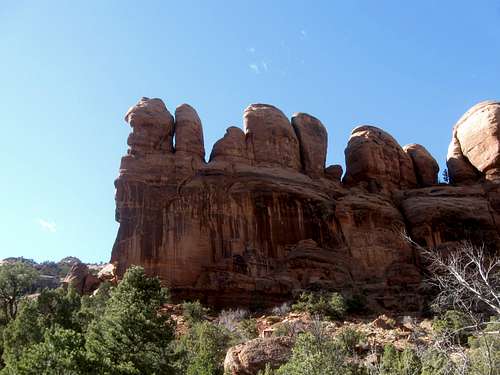
 Walls in Rough Canyon.
Getting There
Rough Canyon is accessed of the Bangs Canyon Trailhead. To get there, follow Grand Avenue in downtown Grand Junction west until it turns into Broadway and crosses the Colorado River. Just after the river crossing turn left on Monument Road (note: the traffic light says "Power Rd"). Follow Monument road for .2 miles. Turn left on D Road. Follow this road as it courses through a few houses for 1.2 miles until you come to Little Park Road. Turn right on Little Park. Now follow Little Park for 5.5 miles as it winds its way through sandstone canyons and platforms. Turn left at the Bangs Canyon Trailhead.From this trailhead follow a gully down into the canyon. At the bottom you will encounter a sign that points you either right to the Mica Mine, or left to Rough Canyon. If Rough Canyon is your destination, then turn (you guessed it) left.
 Rough Canyon as viewed from near the Mica Mine.
Hiking
Rough Canyon Route (class 2+)From the trailhead hike/scamper down the creekbed into Rough Canyon for half a mile until you get to a small, ten-foot waterfall. Circumnavigating this is the biggest challenge you will face on the trail. The usual route is to downclimb a short cliff to the left the waterfalll. A sneak route far left, up and around this whole section is available, but the short class 2+/3- scramble is not difficult. Just after this move the trail turns away from the streambed to avoid another, bigger waterfall. The section that follows is narrow with some exposure to hiker’s left (when headed downstream). After this point the canyon opens up. Another half mile or so downstream brings you to the lower waterfall. Off to your right in this area you can see the Tabeguache Tower against the right edge of the cliffs.

Mica Mine Trail
This is a scenic and fairly mellow route into upper Rough Canyon, which has interesting rock formations. The round trip distance is 2.6 miles. See the route page for more details.
[img:708774:aligncenter:medium:Rough Canyon as viewed from near the Mica Mine.]
Climbing
Rough Canyon is not a popular climbing area, but there is some potential for trad exploration on some of the walls in Rough Canyon. There are several established routes in Rough Canyon, including at least one sport route. Almost all of the climbs in Rough Canyon are on the canyon's east wall (the left side as you are hiking downstream).Several of the routes established do not have bolted anchors and please do not retro-bolt the existing routes. This is mostly a trad climbing are, so please clean climbing principles.
The Tabeguache Tower (III 5.9+ A1) also offers some desert tower multi-pitch off the Monument (for a full discussion of the trad climbing in Rough Canyon, check out Mountain Project link in the External Links section).
Mountain Project Link to Rough Canyon Area
[img:699958:aligncenter:medium:Rough Canyon crack climb.]
Canyoneering
At the lower end of the Rough Canyon Route (see above), just above the small fall before you start climbing up that road is a rather inconspicuous side canyon coming in from the south (not the more obvious and bigger canyon just to the west). It doesn't look like much from the mouth (most people hiking Rough Canyon walk right by it since it is really hidden), but it slots up a bit higher up. This is what we call "Shaylee's Birthday Canyon". You have to be careful getting to the head because of the crypto. A ~30 foot (didn't measure) rappel from a tree gets you into a bowl just above where the canyon slots up.It's just a really short slot, but is local and would probably be fine for you to practice technique or to help others learn on. There are some fun downclimbs.
The canyon just to the west has a short V-groove slot, with running water, but it is non-technical. There is another tiny slot with a few interesting pools and Moki steps in Lower Rough Canyon as well.
[img:848748:aligncenter:medium:]