
-
 24006 Hits
-
 74.91% Score
-
 5 Votes
|
|
Route |
|---|---|
|
|
40.53370°N / 111.7052°W |
|
|
Hiking, Mountaineering, Scrambling, Skiing |
|
|
Spring, Summer, Fall, Winter |
|
|
Half a day |
|
|
Class 3 |
|
|
Snow to ca. 40 degrees |
|
|
Approach - White Pine TH (Little Cottonwood Canyon) - 7,704'
Take the 6200 South exit (exit #6) off I-215 and follow highway 190 south-east approximately 2 miles to the intersection with Big Cottonwood Canyon road. Continue straight through the stoplight and follow the road another 4 miles to the mouth of Little Cottonwood Canyon, where an electronic billboard on the right provides current road and/or weather conditions.Drive 5.5 miles up Little Cottonwood Canyon (0.7 miles before Snowbird Ski Resort) approximately 30 min from Salt Lake City. There are signs marking the turnoff on the south side of the road for the trailhead parking lot. The turnoff is just past a turn in the road and is easy to miss. The turnoff for the Tanner's Flat campground is passed first, and then begin slowing down once you see the "White Pine Slide Area" sign.
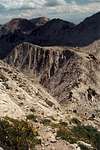
This trail head services 3 different approaches to the E Ridge. One is the standard hiking trail via Red Pine. Another is a steep scramble or snow climb via Maybird Gulch. Yet another is a speculative route along what I have dubbed the Maybird Palisades. Speculative because I haven't climbed it nor have known anyone who has climbed it, but I've scoped it out from both sides and topos and am pointing it out as an interesting possibility.
Stats from White Pine TH to Summit
via Red Pine:
4.5 miles, 3,700 ft gainvia Maybird Palisades:
? miles, ?,??? ft gain, ?,???' lossvia Maybird Headwall:
? miles, ?,??? ft gain, ?,???' lossCommon Approach - White Pine Canyon/Red Pine Canyon Trail Segment
(From White Pine TH to Red Pine Trail Junction)
Distance: 2.5 miles
Elevation Gain: 1,400' gain
For all three variations, take the White Pine trail across the river, and follow the old dirt road/trail as it traverses west before arcing up into White Pine Canyon. At the first switchback (1 mile) there is a faint but still well-used trail crossing White Pine Canyon stream.
Take this trail to reach Red Pine Canyon. This trail climbs out of White Pine Canyon and continues traversing west before arcing up Red Pine Canyon. Just as the trail reaches the Red Pine Canyon stream (elev. 9,100') and the terrain flattens, there is an even more faint trail crossing the stream (2.5 miles). This trail heads into Maybird Gulch. Beware, this turnoff is easy to miss, especially in the winter when the sign and the bridge are covered in snow. From here there are three options to climbing the East Ridge. One is to gain the ridge by climbing the headwall of Maybird Fork, another is to scramble along the ridge dividing Maybird Fork from Red Pine Fork, and the most common way is to head up Red Pine Fork. The respective routes are discussed below.
 |
 |
 |
 |
 |
via Red Pine (cl. 2-3 or 35-40 degree snow)
(from Red Pine Trail Junction to Summit)
Distance: ? miles
Elevation Gain: ?,???' gain
Continue heading up the Red Pine trail until you reach Red Pine Lake, which is 2.34 miles from the White Pine Trail.
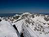
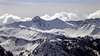
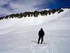
At Red Pine Lake the trail fades, but remains slightly visible for the remainder of the hike. Keep hiking up towards the higher lake. At that lake a small ridge should be visible projecting out from the southwest end of the canyon headwall (it's more apparent closer to the lake). Scramble up this small ridge to gain the skyline (class 2, moderate snow). This moderate ridge is one of two points along the route prone to avalanche danger and is sometimes corniced at the top. From here it is a relatively flat hike along a more obvious trail towards the east side of the Pfeifferhorn along the divide between Maybird Gulch and Dry Creek Canyon.
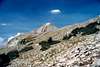
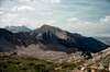
It is along this divide that all of the approach variations from the White Pine Trailhead in Little Cottonwood Canyon and the approach from the Dry Creek Trailhead in Alpine converge. The East Ridge proper rises at the end of the flat segment of the divide.
 |
 |
 |
 |
 |
via Maybird Headwall/Gulch (cl. 2-3 or 35-40 degree snow)
(from Red Pine Trail Junction to Summit))
Distance: ? miles
Elevation Gain: ?,???' gain
This route involves significant boulder-hopping when snow isn't present.
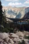
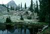
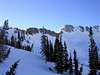
The trail arcs around the rugged ridgeline dividing Red Pine Canyon and Maybird Gulch and heads up the eastern side of the Gulch. From here one is treated with the first views of the Pfeifferhorn. To the right is pt. 10,516, which has a rather interesting summit block spire. To the left is a dramatic rock feature I've dubbed the Maybird Palisades. These offer some possible fun top-roping crack and dihedral climbs. There are three small lakes a little ways off trail to the right (west). These lakes provide your last chance to refill water.
Soon you will reach the open bowl at the top of Maybird Gulch. From here, cross the bowl (a long boulder-hop when there is no snow) and follow the line of least resistance up the steep slope. A more interesting line is to ascend right along the base of the northeast face of the Pfeifferhorn. Once the cirque headwall is gained, scramble directly up the rocky ridge to the summit, or ascend the more moderate trail that switchbacks up a subtle chute to the south (this chute may have some danger of avalanching).
 |
 |
 |
 |
via Maybird Palisades (cl. 3-4+? or 35-40 degree snow)
(from Red Pine Trail Junction to Summit)
Distance: ? miles
Elevation Gain: ?,???' gain
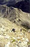
This is probably the slowest variation up the Pfeifferhorn, but for the scrambler, it is also probably the most fun. It is also the most safe from avalanching. It has more exposure than the other variations, with a lot of class 3-4 scrambling.
Take the trail described earlier that branches off from Red Pine and heads into Maybird Gulch. As you round the corner to the gulch, pick your way up to the dividing ridge via the easiest line possible. This end of the ridge is fairly moderate.
As you work farther on the ridge, the ridge narrows, with the west side becoming more sheer than the east side. Eventually you will be climbing up and down around many gendarmes, with an exposed dropoff to the west.
Once on the ridge, follow it all the way to pt. 10,897 and follow the cirque headwall of Maybird Gulch via the remainder of the route described in the Red Pine variation.
WARNING: I have not yet done this ridge, and I haven't seen it described in guidebooks. I determined a difficulty range by how it looked from different angles. Until I can climb it to get confirmation, or someone else climbs it who I can talk to, the difficulty ratings might actually be different than what is listed here.
 |
 |
 |
Approach - Dry Creek TH (Alpine) - ?,???'
Under ConstructionDirections and description coming soon . . .
RT Stats from Dry Creek TH to Summit
Distance: ? miles
Elevation Gain: ?,???' gain
(from Dry Creek Trailhead to Bullion Divide)
Distance: ? miles
Elevation Gain: ?,???' gain
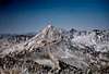
The East Ridge
Under Construction(From flat portion of the divide to the summit)
Distance: ? miles
Elevation Gain: ?,???'
Before reaching the peak, the trail becomes more faint again as you scramble along a mildly exposed ridgeline (class 2-3), mostly follwing ledges on the north side of the ridge above Maybird Gulch. Beyond the scrambling the trail reappears and switchbacks up the east side of the peak in a shallow couloir (people have been nearly killed here from avalanches, and the runout is bad), gaining the summit. One can also opt for a more direct and steeper line by following the ridgeline straight up to the summit from the lower ridge scramble (safer from avalanches).
Essential Gear
Under ConstructionSummer:
10 Essentials and good hiking boots. Water can be refilled at the Red Pine and Maybird Lakes, so little is needed. A helmet is recommended for the Maybird variation.
Winter:
Skis/Snowshoes are can be helpful. Avalanche beacons and rescue gear are a must for ascending the East Ridge as there is mild to severe exposure to avalanche danger depending on the route chosen.
 |
 |
 |
 |