
-
 29744 Hits
-
 73.06% Score
-
 3 Votes
|
|
Route |
|---|---|
|
|
43.74110°N / 110.802°W |
|
|
technical rock climbing, lots of scrambling |
|
|
One to two days |
|
|
5.5-5.7 |
|
|
Approach
Approach via Lupine Meadows trailhead
Hang a right 4 or so miles up the trail (in the middle of the swichbacks) and head toward the lakes (Surprise and Amphitheater).
Continue heading north, and hop over the ridge and head down toward the Teton glacier. Climb the south side of the terminal moraine of the Teton Glacier. The route starts where the moraine meets the mountain.
 |
Route Description
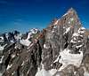
Stay near or left of the ridge as you scramble/climb. See route pictures. You should have no trouble finding places to protect if you feel sketched. The route-finding gets tricky when you reach the feature called the Moose's tooth. If you are competent and want to make the route more difficult, climb up and over the tooth (5.7?). Otherwise find easier routes around the feature to the left (west). After the Tooth, aid (using the short fixed rope) or climb through the supposed crux and scramble up and left of another smaller feature on the ridge. Climb through a small cleft (20 or 30 feet wide) between this feature and another tower on the ridge. At this point you are on the right side of the ridge. Traverse down slightly and then up toward a saddle that defines the east side of the feature you just bypassed. In the attached route photo, a fellow climber climbed this feature and ended up backing off the hand-crack downclimb (which is probably 5.11). You can see the upper red line terminates on this feature. After this, continue climbing east as the ridge gets less defined closer to the summit. The upper snowfields may require an ice ax if the climb is done in the early season. Continue up a chimney system (littered with old tin cans from early expeditions) to the summit.
This alpine route though long (for a Teton route) is not difficult and will be enjoyed by beginners and speed demons alike
 |  |  |  |
Essential Gear
advanced (if you want to do this in a day or less): light ice axe for snow fields if early in season, sticky approach shoes
beginner/intermediate: ice axe, boots+crampons (if early season), cams up to size 3, a few nuts, 60m rope for belayed climbing as needed (near Moose's tooth) and rappel down to upper saddle. Camp near the lakes or at the beginning of the route (on the moraine)
Miscellaneous Info
If you have information about this route that doesn't pertain to any of the other sections, please add it here.
gato - Jul 12, 2004 12:01 pm - Hasn't voted
Route CommentThe feature on the East Ridge that you are calling the Moose's Tooth is actually called the Molar Tooth.
The Moose's Tooth is in Alaska, on the Ruth Glacier, and it is significant climbing objective.
mcdermott22 - Jul 15, 2004 6:20 pm - Hasn't voted
Route CommentYou're right. I should have caught this. Thanks for the correction.
ryan
Brian in SLC - Sep 5, 2007 10:40 am - Hasn't voted
Route commentRoute finding past the Molor Tooth isn't as difficult as weaving in between the first and second tower up higher on the route, methinks. The tricky traverse is a recommended variation below the Molor Tooth. Pretty straightforward.