
|
|
Route |
|---|---|
|
|
38.72500°N / 111.056°W |
|
|
Technical Canyoneering |
|
|
A long day |
|
|
Canyoneering 3A-III (Can be upclimbed at 5.6) |
|
|
Getting There
A journey to out in the middle of no-where............
As mentioned, just finding the trailhead is a navigational challenge. You must do the vehicle shuttle the day before the trip as it will be a long day just getting through the canyon. You absolutely must have the 7.5 minute quads (maps) Big Bend Draw and Ireland Mesa for the drive to the trailhead. Even then, the maps are inaccurate especially near the trailhead. A 4wd is also required.
To get to the trailhead at the head of the canyon, drive west from Green River, or east of the Emery area along I-70 to exit 108. You must carefully follow the topo maps for the remainder of the drive. Take the southbound gravel road and veer right after a short distance. Stay on the main road until you reach Kimball Draw at an intersection with a sign. This is at about co-ordinates N38*47'16.47" W111*5'52.69". Turn left onto the dirt road signposted for Copper Globe. After following the bottom of the wash for a while, you will reach an intersection (no sign and it can be hard to spot) at about co-ordinates N38*47'4.42" W111*4'34.19". Turn right onto a seldom used track. Follow the track in and out of several drainages until you reach an intersection at a top of a hill at about co-ordinates N38*46'24.02" W111*3'57.04". Turn right here. The road weaves in and out of drainages and scenic and colorful badlands and is one of the most interesting pieces of road construction I've ever seen. There are some sections of the road that pass through sparkling gypsum beds. Not too far after the road climbs out of Dizzy Trail Canyon (see the topo map), you will reach a junction next to a small hill with a cairn (pile of rocks) on top. From here on, the topo map is inaccurate as far as showing the many tracks go, so pay attention closely to the topographic features on the map. There are many routes to the trailhead, but here's the route we took. Turn right at the junction with the hill and cairn. You will cross a few very rough spots in the road while crossing two washes. After the second wash, make a very sharp left turn onto a track that heads east. The trailhead and where you're aiming for is very near the 6350 elevation marked on the Ireland Mesa quad NW of the word "DIKE" on the map. We parked here. There are actually several possible trailheads, including following the track marked on the topo map down to Poncho Wash. We chose to start here because we did Gem Canyon (see the mountain page on that canyon) on the same trip.
Make sure to leave Green River or Castle Dale with a full tank of gas! This area certainly is out in the middle of no-where!
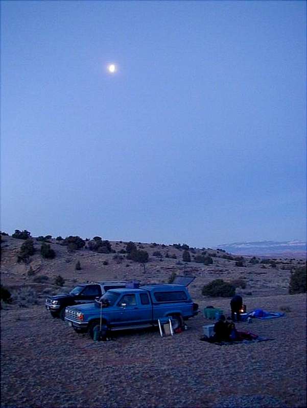 This is the campsite at the trailhead. Although the picture of the trailhead is not that interesting, it is necessary to include it in the mountain page, because you must match this location to the photograph to find the correct place to start the trip! The trailhead (no trail or markers) is tough to find!
Route Description
This is a loop hike that descends Enigma Canyon to Muddy Creek, then follows Muddy Creek up stream to Dizzy Trail Canyon, and exits via that canyon. Alternately, you can also reascend the canyon once reaching Muddy Creek.
You must be proficient in routefinding and navigation with a topo map to follow this route. There are several possible routes to the head of the canyon, and all routes require careful navigation with the topo map. There are several drainages that converge before the canyon deepens. Any of them are possible routes and all require some scrambling. Here's the route we took. From the trailhead at elevation 6350 on the topo map, use a compass to head south while crossing several drainages to the little drainage just west of the "D" in the word "DIKE" on the Ireland Mesa topo map. Just head down the drainage. The canyon is shallow for quite a while, but eventually it deepens and you will reach a 3 stepped dry fall. The first two "steps" can be downclimbed (5.5) if you're confident with rock climbing, but the third may have to be rappeled. In 2003 this was a rappel, but by 2007, floods had changed the drop enough that is was a fairly easy downclimb (4th class). Throughout the canyon are chockstones to use as rappel anchors.
Continue down canyon. The canyon gets better and better as you continue. Another drop will encountered that requires a rappel (this can be upclimbed at 5.6). This is followed by a slot section of the canyon. Continue down canyon. A spectacular section with conglomerate walls is reached just before the canyon narrows into the final slot before Muddy Creek. Before rappeling into the final slot, climb up to the bench on the left (looking down canyon) and do some exploring. There are many fantastic rock formations and balanced rocks scattered throughout the bench. After exploring the bench, rappel into the final slot. This is the longest rappel and it is around 60 feet high. There are now three options.
Option #1: The first option is to ascend back up the canyon the way you came. Of course to do this, you may have to leave ropes behind at every drop, and you may have to use mechanical ascenders. If you are confident with climbing 5.7, you can upclimb all the drops, as we did in April 2007.
Option #2: The second option is to hike up Muddy Creek to Poncho Wash and climb the Poncho Chute from Heck. You can then hike cross country to the trailhead.
Option #3: The third option is to hike up Muddy Creek to Dizzy Trail Canyon and use that canyon to exit Muddy Creek and hike to the trailhead. Hike up Muddy Creek crossing several times (usually ankle to knee deep unless at flood stage). Use the topo map to locate Dizzy Trail Canyon. It will be the second major canyon coming in form the right. The first canyon is Poncho Wash. Go up Dizzy Trail Canyon until it narrows and divides. The canyon on the left is Cat Canyon. Dizzy Trail is the canyon to the right. Hike up Dizzy Trail Canyon. There is a short section of bushwacking and sometimes running water. Continue up canyon while staying in the main drainage. The canyon walls taper down and eventually the canyon becomes a wash. There are a few bypasses, but eventually you will reach the 4wd road that you used to access the trailhead. Follow the track back to your vehicle (about 1.5 miles).
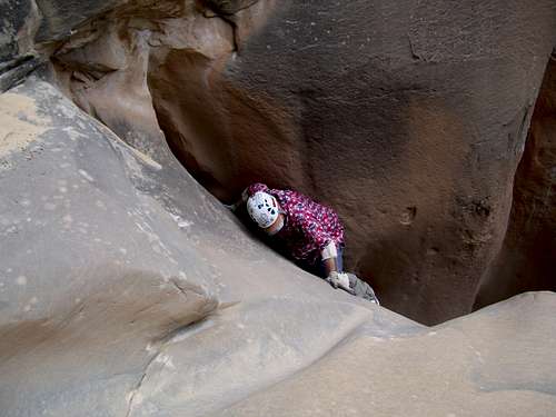 Smear move required to up climb the last falls in Enigma Canyon. The canyon makes an interesting climb.
Essential Gear
Several slings (bring 100 feet minimum), 8-12 rapid links or rappel rings, one meter (200 feet) rope or two 30m meter (100 foot) ropes, and a climbing harness.