
-
 6317 Hits
-
 71.06% Score
-
 1 Votes
|
|
Route |
|---|---|
|
|
36.32460°N / 118.1025°W |
|
|
Scrambling |
|
|
Spring, Summer, Fall, Winter |
|
|
Most of a day |
|
|
Class 3 |
|
|
Approach
Follow the directions on the main page to a parking spot along the aqueduct road west of Cartago. Hike up the old 4WD road, which soon becomes more of a sandy use trail. Either hike up these sandy slopes to the broad east ridge, or head right to hike up the canyon north of the ridge, as shown on this map. The ridge involves some enjoyable scrambling, class 3 in places (although this may be avoided with a little searching around if you prefer to keep to the sand), while the canyon is easier, with probably slightly better footing, and quite scenic. If you opt to hike up the canyon, the drainage is followed up before angling south to where it meets the ridge at about the 9,200' elevation. The canyon is no more than class 1-2, with no dryfalls or other obstacles beyond minor brush and deadfall.Either way you choose to go, follow the upper portion of the broad ridge towards the saddle west of Point 9921. Hike west from the vicinity of the saddle and gradually contour south to reach the summit plateau and its array of trees, crags, and pinnacles.
 |
Route Description
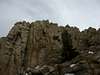
The crux of the climb is identifying the summit. Some trip report authors claim to have found the right crag on the first attempt, but I don't believe them! Most folks should expect to climb a couple of false summits before finding the right one. Some general hints for identifying the summit follow, derived from half a dozen route descriptions on the web (see the linked trip reports for further details) and my personal observations.The Cartago summit plateau rises very gradually to the south. The summit is the southernmost crag on the plateau, tucked away in the southeast corner of a flat, sandy area with fewer trees than the rest of the plateau. The plateau ends at this point, with a steeper slope angling down to the south. When approaching from the north (as approaches from both the east and west would typically do), if you can see a summit contender further south, you probably haven't hiked far enough and should continue searching. An open, gradual slope leads to the summit crags from the north.
When viewed from the northwest, the summit is the north (left) end of a small L-shaped ridge. The summit block is climbed from the north, and is easy class 3. Several options are possible; the easiest route may be to scramble up boulders under the west face before cutting back to the left to the summit. To assure you that you've finally climbed the right pinnacle, a benchmark (10,539') is found on the summit, and as of October 2004, a register is tucked between the boulders along the ridge.
All this sound confusing? It is. Good intuition is helpful for identifying the correct block. For those who prefer to rely on technology, here's a GPS waypoint for the summit:
TOPO! GPS Data Format UTM NAD83 ElevFeet Local-Time
SUMMIT,11S,401055,4020587,10426,11/11/2004,22:50:07,CARTAGO SUMMIT BLOCK
 |  |