
-
 5273 Hits
-
 71.06% Score
-
 1 Votes
|
|
Route |
|---|---|
|
|
68.18731°N / 14.27229°E |
|
|
Scrambling |
|
|
Half a day |
|
|
Class 4 |
|
|
4th class |
|
|
Approach
Find your way to Henningsvær. The road is numbered 816 and turns off from E10 about 30 minutes driving from Svolvær. On the way to or from Henningsvær, (which is very much the end of the road), the road crosses a tidal lake. This is Djupfjorden. There are several places to park and camp in this area. Hike along the North Shore of Djupfjorden until reaching a moraine separating it from a higher freshwater lake with a small waterfall in-between. Cross over in the dense conifer forest. Directly across from you should appear a U shaped valley which is wide at it's mouth, but rapidly narrows. This is Durmålsdalen. The trail going up this valley is difficult to follow in the beginning as it goes between bare granite slabs and marshy ground. Follow this valley to the col between Vågakallen on the left, and Kvanndalstinden on the right. Kvanndalstinden is comprised of two very different types of rock, it is gniess atop granite. The black\brown color differential is distinct.
Route Description
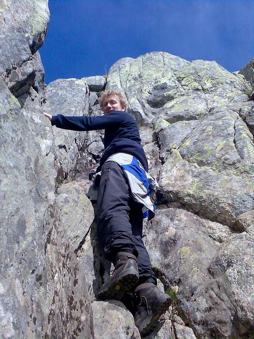
From the col, head slightly down across grassy slopes to the left of the col. In early season this will be a large snowfield with a long runout. In summer, it is a small yet distinct path. If your route finding skills are sharp, you will see that this small path leads to the well worn left gully of two gullies. 3rd class this to the west ridge. From here there are two choices. Following the ridge leads to a perfect knife edge called Hustaket (the houseroof) where one can choose to sit and hunch across, or dance over. Or, there are a series of thin ledges and cracks below the ridgetop to the right (south). Either way makes for an exciting traverse, as there is an overhang below on the right, and plenty of steepness to the left.
A short climb before the top of VÃ¥gakallen, the easy route.
After this traverse, head right of the ridge to another long and large gully on the south face. While loose in places, the most difficult 4th class sections have been worn down to only solid rock by previous parties.
After the gully, there are a series of cairns showing the easiest way to the summit. Exposure increases here, and there are plenty of fifth class options if one gets lost. The easiest line is usually up and slightly right.
An exposed slab called "Hustaket" that you have to pass just before you reach the top of VÃ¥gakallen.

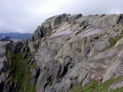
Looking down the South Face route not far from below the summit. At bottom center is the "Houseroof". (Hustaket) The possible traverse below the ridge is the the left in shade. The gully up to the ridge is left of the houseroof, NOT the bigger one further away. Up and left of the photo, the col between VÃ¥gakallen and Kvanndalstind is almost visible. Blocking the sun to the upper right is saugjerderyggen (sheep fence ridge), an exciting 5.6 ridge traverse.


Essential Gear
A rope for beginners as exposure gets fun in places. Locals familiar with the route do it in running shoes. Spring conditions will require a ice axe and crampons as the steepest sections will be snow/ice filled.
Why you should climb it.
Vågakallen has a strong peak value. There are no other summits closeby that are close to it in elevation. It being right on the edge of Ofotfjorden, one has a commanding view across to the mainland, and to the other peaks of the Lofoten chain. It is a singular peak, that rewards much in summit views for the effort put out to reach it's summit.