
-
 4433 Hits
-
 73.06% Score
-
 3 Votes
|
|
Route |
|---|---|
|
|
47.34810°N / 11.07700°E |
|
|
Hike |
|
|
Half a day |
|
|
Walk-up |
|
|
Route overview
| ~ 1600m / 5250ft | |
| about 4-6 hours (ascend) | |
| Parking lot of the charilift "Mundelift" near Leutasch. | |
| Beautiful hiking with some parts of easy climbing (UIAA: I - II). |
Approach
Sarting point is the parking lot (free parking!) of the "Mundelift" about 2km from Leutasch.
Using "Mundelift" to Rauthhütte (1605m / 5264ft) will shorten your ascend by approx. one hour.
See the main page for a detailed description of reaching the trail head.
Route Description
The trail to Rauthhütte starts at the right end of the parking lot. This path (# 8) leads into the forest and you' ll reach the hut within 1 hour.
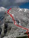
After leaving the hut the path gets steeper and the views to the surrounding mountainside are getting more interresting. At about 1900m / 6233ft the easy climbing parts start (see this photo). After this "gully" the path stays very steep and sometimes it may happen, that you' ve lost the path... but the direction is always up!
Finally you reach a shoulder which leads to the east summit (2592m / 8503ft). From here path #8 still leads on to the main summit of Hohe Munde.
Descent the same way.
 |  |  |  |  |
Essential Gear
In summer hiking gear is sufficient.
In winter special gear like crampons or snow shoes (depending on snow conditions!) are needed!!! - A huge amount of experience is needed to judge alpine dangers like avalanches!!!
Miscellaneous Info
If you have information about this route that doesn't pertain to any of the other sections, please add it here.
selinunte01 - Jan 3, 2009 11:28 am - Hasn't voted
Partly new trail - east slopeDue to construction works for avalanche protection on the east summit of Hohe Munde and its southeastern slopes parts of the east slope trail has been transfered. A new trail bypasses the first rock chute to the south. It regains the old trail above this chute. At about 1900 m altitude the old trail is blocked. A new one was installed further north (see and follow the signs). It avoids the uppermost eastsoutheast slope due to possible rockfall from the construction site. The new trail traverses north to the northeast slope of Hohe Munde and then zigzags up this part of the slope. It reaches the old trail at about 2400 m altitude. The old trail leads to the east summit. Actually the east summit is more than a mess due to the construction site. Iron frameworks, avalanche nets, some helicopter platforms, a huge building for the workers and several power engines litter the summit. Though those works are undoubtedly necessary (see http://hilfe.lebensministerium.at/article/articleview/60753/1/14426/ for further infromation), the east slope ascent is no more fun. Good hikers should choose the west ridge via ferrata for climbing Hohe Munde.
Lukas Kunze - Jan 3, 2009 3:40 pm - Hasn't voted
Re: Partly new trail - east slopeInterresting reading. I looked at some photos of Hohe Munde I took this year and I could see the avalanche fences and the building. Have to go up there to have a closer look. One beautiful mountain lost... :(