
|
|
Route |
|---|---|
|
|
27.91919°N / 86.76590°E |
|
|
Mountaineering |
|
|
Expedition |
|
|
5.8 (YDS) |
|
|
variable, steep ice and snow, rock |
|
|
20 |
|
|
VI |
|
|
Overview
From the Mount Everest approach, Cholatse appears as a dramatic tooth of ice and rock. However, if you look at the mountain from the West in the Gokyo Valley, the angles aren't quite so steep, and ascents appear somewhat more moderate. One of the best vantage points for looking at Cholatse is from the summit of Gokyo Ri, where the peak dominates the view to the South East. From this vantage point, the South West Ridge forms the right sky line of the peak.This was the route used to make the first ascent of Cholatse by John Roskelley, Vern Cleenger, Bill O'Conner and Galen Rowell in 1982. Climbing in the pre-monsoon conditions they found many pitches of steep ice and difficult climbing. When an American/Canadian/Argentinian expedition repeated the climb in October of 1993 most of the ice was covered, and the climb was largely a steep snow climb with an icy crux to reach the summit plateau. More recent expeditions in 2004 and 2005 have found that ice in the bottom portion of the ridge has melted out leaving somewhat scary rockclimbing.
Getting There
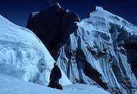
 John Climaco climbing steep ground near the summit plateau on Cholatse's South West Ridge. Photo by Andrew Brash.
Day 1: Fly to Lukla, walk up the Dudh Kosi gorge for a few hours that afternoon. One observation we found was not to filter the river water as the silt quickly clogs the filter. Use water from a clearer tributary instead.
Day 2: Continue up the gorge, crossing the river a couple times. Eventually, climb a steep hill with the first possible views to Mt. Everest. Finish the day in Namche Bazar.
Days 3 and 4: Acclimate in Namche. There are some spectacular early morning views of Mt. Everest from the slopes surrounding town. Often by mid morning mists obscure the views, though. Check out the ridge on Tramserku. It's never been climbed to my knowledge.
Day 5: Leave Namche on the trail to Mt. Everest. Near the town of Khumjung, take the trail that climbs steeply up and over a 3973 meter shoulder of Khumbui Yul Lha then descends steeply to the small hamlet of Phortse Drangka. There are spectacular views of Ama Dablam this day if the weather is clear.
Day 6: Climb steeply up and out of the trees and lush fields into the higher alpine zone around Dole. Be sure to look back a couple times to the incredible peaks around you! Continue along a more level path to Machhermo to spend the night. Legend has it that in the early 1970's, yeti came down into this town and attacked a couple yak, so be on the lookout for this elusive creature. There are also spectacular views of Kyajo Ri on the west side of the valley and the first views of Cholatse to the east side if the weather is clear.
Day 7: Continue up the valley, but instead of going toward Gokyo, take a spur path across the river to Na. From here, work up first trails then open slopes to reach the base camp in the flat fields of the valley above Ganglha. The base camp is on the left side of the valley right where an old lateral moraine dips down into the flat valley floor. This is a beautiful place with clear running water and a spectacular view of Cholatse, the surrounding peaks and a row of sharp spires on the ridge just to the north.
From here, it is recommended to acclimate for 5 - 7 days while you investigate the route on the lower glacier, etc. prior to a summit attempt.
When to Climb
 The 1993 Camp 3 on Cholatse. Photo by Andrew Brash.
Route Description
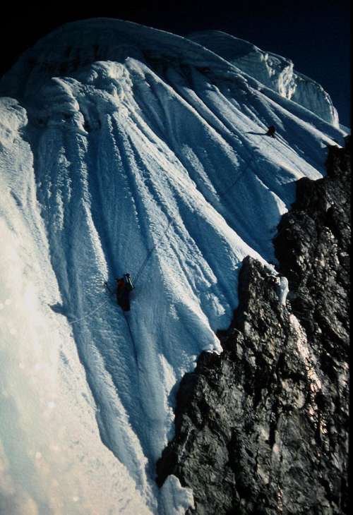
 Cholatse is the peak on the left. The first difficulty in the route is the distinct small icefall near the start of the glacier. Many parties have found that by working right you can find a strip of less fractured ice at the extreme edge of the glacier. This is visible in this picture taken by William Marler. Eventually you will be forced back towards the left into the topmost part of the cwm. Climb the steep wall to the obvious saddle. From here, ascend the steep tower (now lots of rockclimbing) past a small notch and up the narrow ridge forming the right edge to the peak in this view. The angle and climbing eases at about 6000 meters.
 Detail of the current route through the ice fall. Photo Greg Sievers.
From the head of the glacial valley, climb the spectacular fluted snow wall before you. This might involve considerable groveling. The wall is about 200 meters in height and brings you to a beautiful saddle between Pt. 5706 and the peak of Cholatse. This makes an outstanding campsite.
 Climbing the tower's rock face. Photo by Greg Sievers.
 The South West Ridge of Cholatse viewed from the top of the rock tower. Photo by Greg Sievers.
The next 3-400 meters from this notch to the summit plateau constitute the snow/ice climbing crux of the route. The climb generally follows the right side of the steep ridge and involves steep ice and snow climbing with a constant trending to the right. This slope picks up a lot of sun and the snow tends to get quite rotten. For this reason, it has twice been climbed during the night to take advantage of firmer conditions. The final headwall before the summit plateau approaches 70 degrees or so and can be ascended by a rising traverse to the right, then a cut back left to gentler ground. A couple more pitches up less steep terrain bring you to a level spot that was used as a high camp in 1993. It is an incredibly spectacular spot, but does have some vertical ice walls above that could provide some risk. From the level spot climb up steeply then right to a more gentle slope. Follow this up to the final summit ridge of the mountain. As the summit is approached, there are large towers of ice that have to be weaved through, some with short steep walls to climb. The final summit ridge grows increasingly steep until the summit is a small pedestal surrounded by huge drops. It is the fairytale summit that we all dream about. In this last section of the climb, the view opens up with Cho Oyu, Gyachung Kang, Pumori, Everest, Lotse, Makalu, Ama Dablam and many other peaks surrounding you.
 The Crux Pitch, 1993.
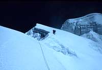 Climbing the South West Ridge, 1993
Essential Gear
 On the false summit of Cholatse. Photo taken by Andrew Brash.
You will want the usual high altitude camping gear:
-four season tent a small footprint comes in handy.
-stove and fuel canisters - stoves that hang are a good idea since the ridge is narrow. There is no water other than melted snow once you are on the mountain.
-very warm sleeping bag -30 degrees C or warmer
-pee bottle (again the ridge is narrow but be careful not to drink from it)
-water bottles and cook kit.
-warm clothing: bring what you're comfortable climbing with in cold conditions. I had about five layers including a shell, a mountaineering pants and bib, fleece, a down jacket, balaclava etc. and was not too warm high on the mountain.
-headlamp(s) with spare batteries. Both in 1993 and 2005 the steepest part of the ridge was climbed at night to get better snow conditions.
-An alpine rack including pitons. The rockclimbing has become more extensive in the past decade so I can't say exactly what is needed at this point.
-a number of ice screws. You will need more in the spring and fewer if you do the climb in October.
-multiple snow pickets. We probably left 8 - 10 deadmen pickets in descending the mountain as well as some screws and v-threads.
-considerable extra webbing for descent anchors
-knife to cut the webbing
-at least a week's worth of food to eat while on the mountain plus food for base camp, etc.
-helmets
-crampons
-ice tools
-ropes. We fixed over several crevasses and then the headwall leading up to the col and a couple ropes on the tower above.
-at least 2 pairs of glacier glasses
-cameras, etc.
If you're attempting this mountain, you know what to bring. . .
External Links
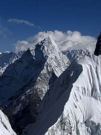 Ama Dablam from the South West Ridge of Cholatse. Photo by Greg Sievers.
Andrew Brash wrote a description of the 1993 ascent of the South West Ridge in the 1994 Canadian Alpine Journal, Pgs. 118 - 120.
John Climaco wrote a brief description (with a fabulous photo) of our 1993 ascent of the mountain in the 1994 American Alpine Journal and Andrew Brash added his comments on this web page.
A brief description of the 2005 ascent of the SW Ridge including a route photo can be found here.
Movie of Cholatse Ascent
The 2005 expedition to the S.W. Ridge of Cholatse made an outstanding movie, Light of the Himalaya, of both their climb of Cholatse and work by the team to fix cataracts in the Nepalese people. The film has won multiple awards and shows detailed pictures of the South West Ridge Route to the summit of the Peak. It can be purchased here for about $30. Sixty percent of the cost goes directly into the foundation that works on curing cataracts. By buying this movie you will be donating enough money to more than cure a person from blindness.
dmiki - Nov 27, 2010 6:37 am - Voted 10/10
broken link + further infoThe 1983 American Alpine Journal (the 1982 ascent): http://books.google.hu/books?id=Jon-SXnhElsC&pg=PA15 The 1994 American Alpine Journal (the 1993 ascent): http://books.google.hu/books?id=VdEPD-6OitEC&pg=PA218 http://web.archive.org/web/20090806001904/geocities.com/andrewjohnbrash/cholatse.html