
|
|
Route |
|---|---|
|
|
61.63838°N / 8.30772°E |
|
|
Mountaineering |
|
|
Spring, Summer, Fall, Winter |
|
|
Most of a day |
|
|
Alpine Grade F |
|
|
Overview
 Short distance below the summit of Galdhøpiggen
The route from Spiterstulen is a straight forward and non-technical 1400m climb. It takes around four hours to climb Galdhøpiggen with two hours required for descent. The majority of the route is across rock or snow depending on the season. There are some small sections of the glacier to cross close to the summit and crampons may be required, particularly if the ice is exposed. Knowledge of weather and sure-footedness on scree and boulder terrain are the main requirements. The route is extremely popular and it is not recommended to climb during holidays if you want to avoid the crowds.
Getting There
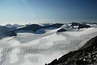
 Summit of Galdhøpiggen with the Styggebrean glacier leading off to the right
The mountain lies in the heart of Norway equidistant from Oslo, Bergen and Trondheim. Lom is the gateway town for Jotunheimen. Nor-Way has about five buses a day from Oslo which go via Oslo Gardermoen airport. NSB have trains from Oslo to Otto from where there are connecting buses to make the short ride to Lom. Bus times coordinate with train arrival times. From Oslo take the E6 to Otta (308km) then Road 15 to Lom (64km). From Lom take Highway 55 (Sognefjell Mountain Road) and then turn off for either Spiterstulen or Leirvassbu (for Geitsætre). Both are sign-posted. In the summer there are buses that travel along Highway 55 between Lom and Sogndal. Out of season you will need your own transport otherwise prepared to hitch (or walk!). Spiterstulen is 35km from Lom and about 15km south of Highway 55. The Spiterstulen road is open year round.
Route Description
 View down to the Styggebrean glacier from close to Galdhøpiggen's summit
From Spitastulen cross the bridge over the Visa stream, turn right through a small camping area at which point a path branches off left. This is the path to Galdhøpiggen’s summit. It is initially well defined however soon disappears as you pass over a crest. The route is marked all the way to the summit by a series of rocked painted with a red ‘T’ so there is little chance of getting lost. The route continues over loose rock to meet the long ridge that passes over two preliminary peaks on the way to the summit. The first is Svellnosi (2272m) and the second is Keilhaus top (2355m). Once on he ridge there are good views west across the Svellnosbrean glacier and east across the Styggebreen glacier. The final ascent from Svellnosi top is across scree, ice and snow. On reaching the summit a tremendous 360° panorama, stretching all the way to the ocean opens up.
Views from Summit
 View South View South |
 View West View West |
 View North-East View North-East |
Camping and Accomodation
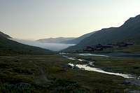 Spiterstulen
Spiterstulen Lodge
Staffed private lodge with 120 beds.
Season: About 1st May to mid-October
Email: post@spiterstulen.no
Tel: +47 61 21 14 80
Fax: +47 61 21 19 72
Wild camping is legal in Norway meaning those on a budget can minimise the expensive costs by taking a tent. You are not allowed to camp within 150m of roads or buildings however. In the Spiterstulen area the rule is slightly different. You must either camp on the campsite on the east side of the footbridge (50 Kr per night) or camp over 1km away. Camping within 1km may prompt a visit from Spiterstulen staff to collect a camping fee.
Essential Gear
 Climb to second peak Keihaus topp on route to Galdhøpiggen
Warm clothes
Gaiters (depending on conditions)
Crampons (advisable)