
-
 17912 Hits
-
 90.13% Score
-
 31 Votes
|
|
Route |
|---|---|
|
|
61.63630°N / 8.31236°E |
|
|
Mountaineering, Ice Climbing |
|
|
Summer |
|
|
Most of a day |
|
|
Alpine F |
|
|
I |
|
|
Overview
Geographical classification: The Scandes > Jotunheimen > Galdhøpiggen > Styggebreen Glacier Route
Styggebreen Glacier Route - Galdhøpiggen
Galdhøpiggen 2469 m belongs to the Jotunheimen massif, located in the magnificent Jotunheimen National Park, in the middle of Southern Norway, between the counties of Oppland and Sogn og Fjordane. In the Norwegian language Jotunheimen means "Giants Home" and it's quite a proper word, due to the fact that the 26 highest mountains in Norway are located in this area. Galdhøpiggen is the highest peak and probably the most popular one to climb in this region, due to its elevation and its charming situation. The mountain is surrounded on three sides by expansive glaciers: the Styggebreen Glacier lies to the North, the Storejuvbreen Glacier to the West and the Svellnosbreen Glacier to the South.
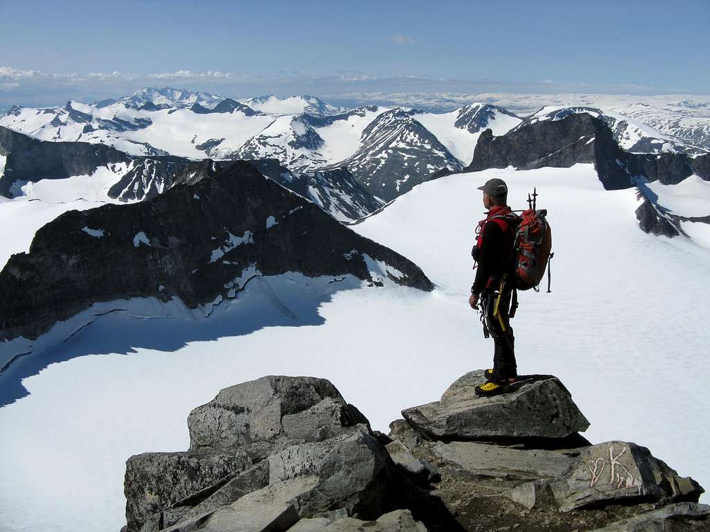
Summit of Galdhøpiggen
Galdhøpiggen with its 2469 meters above sea level is the giant of the country, though it’s only a handful of meters higher than the neighbouring Glittertind. Getting to this summit means to climb the highest point of the whole North Europe and above all it also means to overlook an unspeakable sight on mighty glaciers all around.


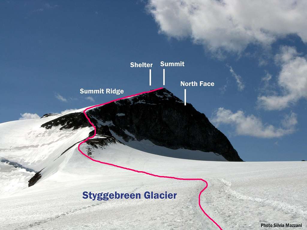
The Styggebreen Glacier Route is the shortest way - but not the easiest - to reach the summit of Galdhøpiggen, with a difference of level of 600 meters: an easy and straightforward route, rising from the North-Eastern side and very popular - like the normal one from Spiterstulen - but involving a complete glacier's equipment. As a matter of fact this route is a superb and satisfactory ascent crossing the Styggebreen, a mighty glacier with several crevasses, sometimes hidden by snow in early season or after summer snowfalls. In the upper section the route follows a rocky and snowy ridge, then rises along easy snow-slopes to the little summit stone-shelter and finally to the top.
Getting There
From Oslo follow the E6 to Hamar, Lillehammer and Otta, here turn to left following Road 15 toward Vagamo and Lom. This small and lively town is the best starting point to climb Galdhøpiggen and the gate to the whole Jotunheimen National Park. Approximately 90% of the municipality of Lom is covered by glaciers and mountains, with Galdhøpiggen and Glittertind being the two well known landmarks. Lom has several accommodation, a camping with cabins, hotels; here you can visit the 850 years old Lom Stave Church (Stavkyrkje), one of the largest one in Norway.


From Lom follow to the left the Bøverdalen Valley (Road 55); that is the starting of the mythical Sognefjellsvegen, an unbelievable mountain road connecting Lom to Gaupne, crossing glaciers and the highest mountain pass in Northern Europe. After about 19 kms. at Galdesand you must exit RV 55, turn to left and follow a toll road (sign-post, vending-machine at Raubergstulen) leading to Juvasshytta Hut (mt. 1840). Parking.
Styggebreen Glacier Route report
Styggebreen Glacier Route
Difficulty: Alpine F
Difference in level: 630 m.
Exposure: N, E on the ridge
Starting point: Juvasshytta Hut m 1841
An easy straightforward route to the highest summit of Norway. The climb doesn't require particular mountaineering skills, but the glacier is crevassed and demands to enrope and to be careful. The environment is wonderful, as the summit view.


"Styggebreen Glacier Route" report
From the Juvasshytta Hut take a well worn path heading South and crossing a flat stones scree. Skirt the East shore of Gjuvvatnet Lake, often iced also in summertime, then cross some snow-fields. Where the path forks, ignore on the left the trail to the Spiterstulen Hut and head slightly to South-West, walking on a well cairned path and crossing some other snow-fields. After a short descent, the route gains the edge of the Styggebreen glacier. The glacier must not be taken lightly: here it's better you rope up! Begin to cross straightforward the glacier towards South-West, heading towards the obvious and superb North face of Galdhøpiggen. The glacier is ending to a snowy steep slope; climb it reaching a large rocky and snowy ridge (huge cairn), where the fine black granite North face of Galdhøpiggen does entirely appears.


The large ridge climb up to reach the peak’s left edge, facing East and leading to the ending snow-slopes. Climb those, reaching the little stone-shelter and the beautiful summit signal (3 hours from Juvasshytta Hut to the top).
Descent: reversing the same route.
Essential Gear
Rope, axe and crampons; Prusik loops and ball-knot are recommended

Huts

- Juvasshytta 1841 m is the closest hut having sleeping accommodations; it is a modern tourist lodge open from the end of May to the middle of September with 75 beds. Phone +47 61 21 15 50 mail to post@juvasshytta.no

- A little stone-hut is located on the summit, offering warm drinks and a good shelter in case of bad weather, when it is manned.
Red tape

No particulary restrictions. The route is situated inside the superb Jotunheimen National Park, established in 1980, covering an area of 1150 km.2 and including the 27 highest peaks in Norway. Jotunheimen is located between Oppland and Sogn og Fjordane counties and it's bordered by the great lake called Vågåvatnet, the valleys of Bøverdalen and Leirdalen and the road No. 55 (the mytical Sognefjellveg) to the N and NW, by the Road 51 to the East, by Bygdin, Tyin and Årdal to the South and by the mountain road between Årdal and Turtagrø to the West. Visit Jotunheimen
When to climb
Best period to climb Styggebreen Glacier route goes from the end of June to the end of August.
Surroundings


Meteo
- Meteo Lom
- Galdhøpiggen Forecast
Guidebooks and maps
Guidebooks


- "Walks and scrambles in Norway" Hiking, Scrambling and Mountaineering in Norway guidedebook by Anthony Dyer - John Baddeley - Ian H. Robertson - Ripping Yarns 2006
- "Opptur Jotunheimen" by Finn Loftesnes - 125 selected itinerary on Jotunheimen - Selja Forlag 2009
Maps
- "Jotunheimen Vest" - Turkart 1:50.000 - 2505
External Links
- Scandinavian Mountains
- Jotunheimen
- D.N.T. Den Norske Turistforening