
|
|
Route |
|---|---|
|
|
46.42058°N / 13.47645°E |
|
|
Hiking, Mountaineering, Scrambling, Via Ferrata |
|
|
Summer, Fall |
|
|
Most of a day |
|
|
First nice marked route then some secured parts on ferrata Ceria Merlone. |
|
|
Getting There
For this ascent you must deter from the highway in Chiusaforte and travel through Rakolana (Reklanica, Raccolana) valley to Sella Nevea (Nevejsko sedlo) pass, 1142 m. This pass can also be reached from Tarvisio towards south through Valle Rio di Lago (Jezerska dolina). On Sella Nevea you turn towards north-west and drive by a narrow alpine road to Malga Pecol (meadow), 1520 m.Route Description
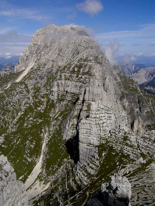 The view on mighty Montaz, 2754m from the summit ridge.
From the parking place you continue in the NE direction over the macadam road all the way up to well visible hut Rif. Brazza, 1680m. From the hut you continue in the north direction to the crossing. Here you follow the signposts for Spik Hude Police / Cima di Terrarossa. Before you come to the steeper part of slopes you cross nice grassy slopes where you can hear, rarely see, a lot of marmots. Soon you come to the steeper part where in many switchbacks you cross the south slopes of Spik nad Tratico / Cima Cambon, 2391m. The route is well marked and very wide. It is an old military route. In sunny days here you will meet many people.
Soon you come to the start of the ferrata Ceria Merlone, where you turn in east direction. You cross the steep grassy slopes below the ridge all the way to the notch Forca de lis Sieris, 2274m.
From here you continue to the start of the steep ravine. First you walk over the steep scree and then you come in to the short wall. You climb it up with help of iron cable. You reach the south ridge. Now you climb all the way to the man ridge. Somewhere you have to climb a bit. When you come to the ridge, the route turns to the right and over airy ridge you reach the main summit of Spik nad Nosom, 2531m.
From this summit you descend a bit to the big pass between the summit of Spik nad Nosom and Spik nad Spranjo. Then you continue over the route to the best place where you can reach the summit of Spik nad Spranjo with easy climbing.
You descend by the same route or you can continue over the ferrata Ceria Merlone.