
-
 19861 Hits
-
 90.77% Score
-
 33 Votes
|
|
Route |
|---|---|
|
|
48.70880°N / 113.856°W |
|
|
Mountaineering |
|
|
Summer, Fall |
|
|
Most of a day |
|
|
Mostly Class 2 and Easy Class 3 |
|
|

|
|---|
| To visit Glacier National Park is to enter a place where Heaven touches Earth affording brief glimpses into the Wonders of Creation. |
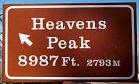 Heavens Peak Sign from The Loop
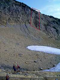
 The incredible rock on the east rim of Heavens Peak
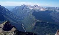 Heavens Peak from Mount Gould.
East Face Route Overview:
 Just above the first waterfall.
This route found in Volume 3 of Climb Glacier National Park. This is an updated book featuring full color photographs of routes and much more. Find it when you arrive in the area from local retailers or order it from the author on line at Volume Three.
The route presented here is a pleasant alternative route up Heaven’s Peak with less exposure. The route is class 2 with a few easy class 3 ledges thrown in for fun! It is possible to enjoy incredible views of the Garden Wall, Logan Pass as well as the Sperry Glacier basin. Glacier’s numerous alpine flowers are also in full display until reaching the basin snowfields.
Another unique perspective of Heaven's Peak is gained from the Loop on Going-to-the-Sun Highway where the entire upper portion of the route can be scouted. Exercise caution if large snowfields remain on the upper route.
Click on linked italic text for additional photos.
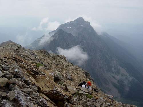
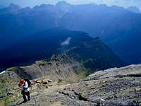 View down route from near summit
East Face Approach & Route:
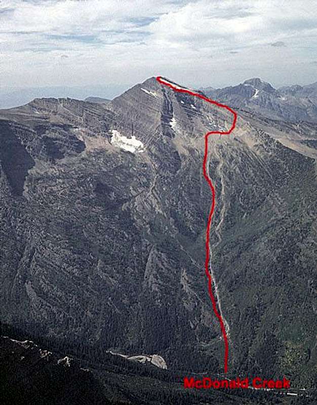 East Face approach and route. Photo and drawing by Fred Spicker.
Note that one must ford McDonald Creek which can be very deep and dangerous early in the season. Be cautious and do not take risks.
The East Face is best approached up the streambed of the largest steam draining the east side of the mountain. This stream enters McDonald Creek six and a half miles north of the Lake McDonald Hotel and is very obvious from the road. There is a good pullout / parking spot almost directly across from its mouth. This area frequently has avalanches and as a result there are large amounts of debris to deal with after crossing McDonald Creek.
The most successful approach to dealing with the underbrush and avalanche debris immediately after crossing the creek may be to skirt around the north side of the avalanche area and stay in the old growth forest as much as possible. It is also possible to follow the various braids of the dry streambed as the first waterfall is approached. Keep in mind that the easiest crossing of the first waterfall is on the south side of the stream. There were many places to cross the stream prior to reaching the waterfall.
Route Description:
 The gully is located in the top center of this photo.
Accessing the basin under the East Face
After the first waterfall follow the stream until a large stream joins the main stream from the left at approximately 4,400 feet elevation where the South Ridge Route splits off. Follow this link, East Face Route, to access a topo map of east side of Heaven’s Peak. The correct route follows the stream that enters the basin at the “s” in Heaven’s Peak. Depending on the amount of water in the stream it may be possible to climb up the stream bed or it may be necessary to follow the left fork (20-30 yards up the South Ridge Route) until on top of the falls and then bushwhack 30-40 yards back to the other fork. Above the fork the route is an uncomplicated climb through meadows and terraced rock gardens into the basin below the East face of Heaven’s Peak. Upon reaching the basin snowfields mark your route of descent well as the stream beds further north are more complicated with difficult terrain and requires increased bushwhacking while descending.
Accessing the Northeast Rim
To access the northeast rim locate a distinguishable gully on the North side of this basin, see attached a photos. Watch for loose rock and climb carefully through the gully to the Northeast rim. Upon reaching the rim it is an incredible ridge walk above the basin snowfields below. The highlight of this climb will be walking up the sloped parking lot sized shelves next to the incredible wall that leads to a snowfield near the summit.
 The above photo shows the final approach to summit with the gap between the summit snowfield and the headwall. It is also possible to skirt the snowfield to the left (East of the snowfield) and achieve the South ridge as well.
 Looking down on the route between summit snowfield and headwall.
Essential Gear:
 Final summit push with McPartland Mountain in the background after reconnecting with the South Ridge Route background.
As with all hiking and climbing in Glacier National Park use caution and practice good manners with the wildlife. You are in bear country. Carry your bear deterrent spray, don’t hike alone and make some noise. For more information please go to the Park's website for Bear Information. The U.S. Forest Service also has helpful information on Grizzly Bear Management.
Hiking poles will aide in your ascent and descent while working through the gap near the headwall and working through Glacier’s wonderful scree!
It may be necessary to carry an ice axe to cut steps through the snowfield at the summit if this route is attempted too early.
Edwards advises a rope, but experienced Glacier Park climbers will probably not need one on the East Face Route since most of the route is class 2 and the class 3 has little to no exposure.
Guidebook and Thanks:
GUIDEBOOK: A CLIMBER'S GUIDE TO GLACIER NATIONAL PARK; J. Gordon EdwardsA special shout out for Fred Spicker for all of his assistance with this page. Thanks Fred!
Thanks to my climbings partners who make everyday in Glacier some of the best days of my life!
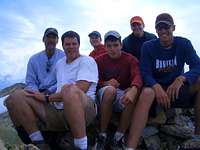 Thanks Guys! In the front are SP members, echoguy (front left) and montanarendonk (front right) and Vantana (rear left)