
|
|
Route |
|---|---|
|
|
28.96751°N / 87.27746°E |
|
|
Mountaineering |
|
|
Expedition |
|
|
High altitude mountaineering |
|
|
Overview
 1. Start from Gyatso La
A very enjoyable high altitude climb in the heart of the Tibetan high plateau!
Excellent views, a beautiful walk in and a great peak to crown it all.
Pulha Ri was unclimbed until early 2008 and the first ascent was made by the east ridge. The altitude gain is about 1600m from the floor of the nearest valley and from a suitable BC close to where the real climbing starts, it's about 850m. In other words; not such a long day climb speaking in Himalayan 6000m peak terms.
 2. After you have crossed a small pass, down a valley with steps of ice on a frozen river
It's mostly a snow and ice climb, but there are some shorter parts with scrambling if you intend to follow the route described here. The catch may actually be the walk in as you either have to deal with hopelessly steep and unstable scree in the warm periods, or with vertical frozen waterfalls in the cold periods of the year. The climb itself is a combination of route finding through some tricky area followed by a straight forward snow climb of 40-45 degrees to the ridge and then a long ridge walk to the summit.
Getting There - To Pulha Ri's foot
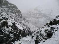
For a detailed description on how to get to Tibet and to Gyantso La, look at the main page. 3. Climb frozen waterfalls in the east gorge
To the foot of the peak from Gyatso La
It's not far from the pass to Pulha Ri, but it's a tough walk and the conditions can vary wildly by the seasons. I went there in late winter and then all the rivers in the deep gorges were frozen solid.
Here's what it's like when you can walk on ice in the gorges.
Head WSW over some small hills down and into a valley. Walk along it for a short time until you see an obvious larger valley leading dead W. Walk up to a pass marked by a small cairn decorated with prayer flags. Head down to the bottom of the valley in the S and take a right towards N. There are some nomad's camps further down the valley. The valley turns into a narrow gorge. In some places passage may be difficult due to steep icy places and you have to use crampons and possibly even an axe here. After about 5km of descent you arrive in yet another valley. Take a left towards the south for about 500m. Cross the river when you see a gorge to the east. Follow it upwards. The ice here had formed steps, which sometimes were frozen waterfalls up to 25 meter high. Some of them you have to climb, some can be avoided. The highest I had to climb was about 6m. Continue until the little rivers splits in two. Take a right. After another km the valley flattens out and gets wider. This is an excellent place for BC, about 850m below Pulha Ri's summit.
 4. Looking down the eastern gorge
If you're not content climbing vertical waterfall ice, you may try out the sides of the gorge. Be prepared for steep, tricky scree slopes and objective danger in terms of rock falls. The latter is also of concern when in the gorge itself.
Route Description
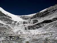 5. The end of the gorge and the way up
 6. The route on the peak
At about 5560m there's a good camp spot. Flat ground and also a little river. Another reason why this place is good is because you have good views of the first part of the route.
You have two main choices.
The first one, which I didn't try due to really bad conditions is to climb straight up towards a gap in the vertical rock bastions. This gap was at the time I was there filled with rotten ice. If you are there later in the season, this route can be a good and much shorter alternative to the long circumnavigating one I had to take.
Head up to the end of the valley. There may be frozen waterfalls here, or they may be full of water. Find a way around them regardless of the state they're in. I went to the right of the main one and climb some small steps of rock until the steep parts are over.
Head left direction the main east face of Pulha Ri. There are many small notches and passages here, but follow the path of least resistance. Make sure to keep and eye on the face as there's objective danger here. Ice blocks and some rocks tumbled past me at several occasions.
| You're at this stretch walking on a huge ledge under the face and when it gets steeper, climb the slope which connects to the east ridge. This is the steepest part of the climb. If you want it less step, head more south/right, but it's also longer. When you are on the ridge you only have to think one thing: be very careful with hidden crevasses! They are there, on the ridge and on the sides of it. Some are very visible, some are not at all. When you are about to finish the ridge proper, it gets a little bit steeper and takes off a bit more to the south. You can either follow it to the corniced area or go more to the left/south. I preferred the latter as it looked less dangerous. The former is again more straight, but there are som crevasse bridges which put me off and the last corniced part looked very steep and it's a matter of climbing vertically to the summit plateau. |  8. The full view of the ridge 8. The full view of the ridge |

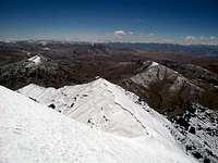
| Traverse below a distinctive steep "horn" and gain access to the eastern flank of the peak. You are almost on the west side when it's suitable to climb up to the summit plateau as you have to climb around a huge crevasse. Let your experience guide you to what's best. You can either go quite close to the crevasse and be on more flat ground, or head for steeper territories and avoid the crevasse danger altogether. When you have past the crevasse, it's an easy snow walk on 20 degrees to the summit plateau. The highest point is on the far side. Don't walk to close to the east edge. The cornice is huge and on some sections quite brittle. |  10. Summit view south - Qomolongma 10. Summit view south - Qomolongma |
Essential Gear
Warm high altitude clothing
Crampons
Ice axe
Walking sticks
Good camping gear
Double boots
Sun protection
Perhaps also a rope and gear for crevasse rescue
Provisions for about a week, if pre-acclimatized
Another ice axe
Ice screws and the normal kit you feel you need for vertical waterfall ice