
|
|
Route |
|---|---|
|
|
46.76398°N / 122.2983°W |
|
|
Hiking, Mountaineering |
|
|
Spring, Summer, Fall, Winter |
|
|
Half a day |
|
|
Route Description
NOTE: This route is in thanks, honor, and recognition to fellow county highpointers Edward Earl, Greg Slayden, and Duane Gilliland, who recommended this route in their Quiemuth Peak trip reports from May 2008. Steep Forested Southeast Ridge
The "Southeast Ridge Traverse" is one of the shortest, most direct routes leading towards the summit of Quiemuth Peak, the highest point in Thurston County, Washington. The route begins at the intersection of Pleasant Valley Road and NFD #74 Road. Travelers follow NFD #74 Road past several (2-3) large washouts, then begin bushwhacking off-road/ off-trail up the steep forested eastern slope of the ridgeline located southeast of Quiemuth Peak. Use extra caution when ascending/ descending the steep ridge slope, as a lot of deadfall, groundcover, soft soil, and unstable terrain engulfs the landscape. No true "hiker's trail" is currently established, but multiple "animal trails" might be intersected and used during the slope traverse.
Upon reaching the top of the ridge, travelers then briefly descend to old Forest Road #017 (which might be shown as Road #015 on some maps). Then Road #017 is ascended/walked until its end due south of the Quiemuth Peak summit. The final stretch of the route entails a traversing up a steep forested slope to the summit.
The total distance for the "Southeast Ridge Traverse" summit route of Quiemuth Peak is approximately 5.0 miles, roundtrip. This is in stark contrast to the much longer "standard" hiker's summit route that is approximately 17.5 miles, roundtrip. Allow 4-5 hours to complete the summit route, roundtrip. The off-road sections (SE ridge, summit slope) of this route are YDS Class 2.
Getting There
From the intersection of Pleasant Valley Road and NFD #74 Road:1) Follow NFD #74 Road west, then northwest. Travelers will pass a closed gate after 0.1 miles, then several (2-3) major road washouts within the next 0.5 miles.
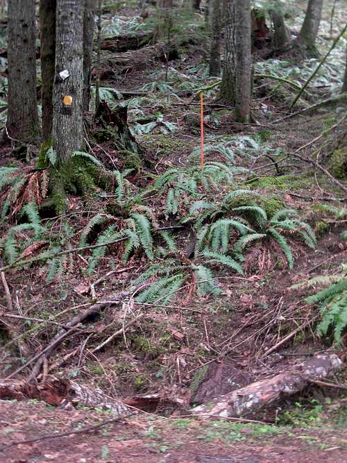 Starting Location For Forested Slope Traverse
2) After nearly 0.75 miles from the start, at approximately 1300'-1350' elevation, begin the traverse up the forested slope on the west (left) side of the road. For route consistency, it is recommended to begin the off-road traverse at the location marked by a tree having a yellow reflector and a small orange post saying "Property Boundary". This "Property Boundary" marker represents the eastern entrance to the Snoqualmie National Forest surrounding Quiemuth Peak.
3) Climb through deadfall, groundcover, and soft soil up the steep ridge slope for 0.5 miles, gaining approximately 1000' elevation to the saddle (2300'-2400' elevation) located between Quiemuth Peak (to the north) and Stahl Mountain (to the south).
4) From the top of the saddle ridge, briefly descend through thick forest growth to Road #017. Ascend the road west for approximately 0.9-1.0 miles, to the road's end (~2600' elevation).
5) Turn north and steeply climb off-road up the final forested slope leading to the summit. The slope has approximately 300' gain in 0.3 miles. The summit is on the west side of the hilltop in a thick forested grove, and is marked by a cairn and summit register (jar).
Essential Gear
No technical hiking gear required.Standard hiking clothes. Long pants recommended, due to amount of groundcover and deadfall along ridgeline.
One hiking pole or hiking stick recommended, for stability when ascending/ descending the steep slopes of the southeastern ridge as well as the final summit slope.