
-
 2440 Hits
-
 71.06% Score
-
 1 Votes
|
|
Route |
|---|---|
|
|
46.53690°N / 13.17866°E |
|
|
Hiking |
|
|
Summer, Fall |
|
|
Half a day |
|
|
Medium hard hike up |
|
|
Rating the Route (By Hiking Standards)
The grading system for hiking and scrambling routes is here.
0. General: From Caserute meadow, 1455 m to 1857 m, exposition E, N and S. First a long, unpleasant crossing of the slopes through woods and dwarf pines, then a steeper ascent over a few a bit exposed (secured) passages, finally a panoramic ridge and steep grassy slopes. Gear: Good hiking shoes and poles.
1. Effort: cca 450 m, 2 h 30 min.
2. Power: 2 - Easy, only walk-up, but also steep below the summit.
3. Psyche: 2 - Easy, only one or two a bit more exposed ledges, secured with a cable.
4. Orientation: 2 - Easy, well marked, also in the woods.
Getting There
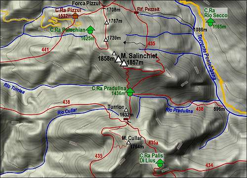
See the parent page how to get into Val Pontebbana and To the upper valley. After we pass Casera Caserute, we park by the bridge, where the road for the first time (in the upper valley) crosses the Pontebbana creek. Altitude is 1455 m.
Map: Tabacco: Alpi Carniche Orientali, Canal del Ferro. 1:25.000.
Route Description

Crossing through forrests
After the bridge, the path No. 435 leads us sharply left, down the creek bed (by its right side), all the time towards the south. We keep the same altitude, the path goes only little up and down. In 2009 we had to cross a lot of fallen trees (spring lavines), but I guess that will be cleaned. Due to these difficulties it took us almost 45 minutes till Rif. Forte di Pezzeit, 1475 m. This point can be reached also directly from the valley of Pontebbana, the trailhead is below Casera Rio Secco, on 1086 m. Also that ascent is supposedly marked (?). From Pezzeit hut one marked path goes right up on Forca Pizzul, but we continue across the slopes in the southern direction. Allways through the woods, crossing many more or less dry (depends on season) water beds. So we approach the N face of Monte Salinchiet, where the terrain is more opened. Scree fields on the right, broad areas of dwarf-pine, the path is still well marked and strong, but after the last ravine (Rio Saline) starts ascending - first slowly, then in a few turns, using one or two a bit exposed ledges. There the path is protected. The crossing continues, finally the path ascends through a forrest on the E-SE ridge, where the view towards the south opens. Less than 2 h till here.

The summit ridge
From the ridge, the path No. 435 descends on the other side, towards the nearby Pradulina alpine meadow. Our marked path, however, turns sharply right and follows the ridge towards the summit. This part of the ascent is interesting because of growing panorama and because of the rests from World War I which we can explore. Towards the summit, our path goes mostly by the S side of the ridge. In the upper part it gets weaker, but the direction is clear. Last some 20 meters are a steep ascent over a rocky slope. So we reach the SE summit, which is 1 meter lower than the NW summit, which we see near by. Climbing there would mean a few passages up to UIAA II level of difficulty.