|
|
Route |
|---|---|
|
|
43.18440°N / 109.65429°W |
|
|
Mountaineering |
|
|
Summer |
|
|
A few days |
|
|
Class 4 |
|
|
Overview
The Tourist Creek and Wells Creek routes access Gannett's spectacular and seldom-visited west face. These are long and difficult routes, covering roughly 18 miles from the Green River Lakes trail head to the summit. For Tourist Creek, the first 10-11 miles (depending on how you do it) are on the easy Highline Trail, but after that there is no trail and very little easy hiking. Once you head up Tourist Creek from the Highline you will encounter brutally steep rock hopping for the next 1.5 miles or so (gaining 2000 vertical feet), which is exceptionally difficult with a backpack.Getting There
From Pinedale, head west on US-191 for 6 miles and turn right (north) on WY-352. Follow WY-352 for 44 miles to the Green River Lakes trail head. There is a campground and water at the trail head, as well as overnight parking for backpackers.Route Description


After gaining about 2000' in 1.5 miles there are some flat grassy areas at about 10,200' that make excellent camp sites.
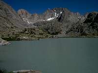
Shortly after the grassy areas, start working right (southeast) to escape the main drainage. The upper Tourist Creek drainage is complex, but if you keep working right whenever you can you will eventually reach a lake at 11,085' under the dramatic southwest face of Mount Solitude.
Heading basically south, pass around the west side of the lake and head for a pass above its south end. The pass divides the upper Tourist and Wells Creek drainages.
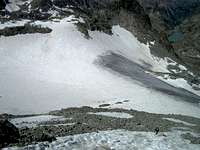
At this point you can see Gannett's west face and the upper part of Minor Glacier that you will be climbing. A prominent finger of snow heads towards the summit from the main part of the glacier. You will ascend this couloir to a talus field climber's left of the top of the snow.
Once on the north ridge, work south towards the summit, ascending class 4 rock. This is fun climbing and not super exposed. A couple of rappel stations have been rigged in recent years for the descent. The rock ends with a short walk across snow to the summit.

Essential Gear
sticky rubber approach shoes for all the rock hoppingtrekking poles would help
crampons & ax
map: Earthwalk Press "Hiking Map & Guide: Northern Wind River Range, WY"
summitascender - Jan 11, 2014 2:14 am - Voted 8/10
VariationThis is a fun and worth while route. I would recommend a fun variation. Ascend the Northwest shoulder as described, and then head south along the entire summit ridge. Drop back down into Scott Lake Basin down the Soutwest Col. in order to circumnavigate the mountain.
mouser - Sep 8, 2014 8:06 am - Hasn't voted
Good spot to cross the Green RiverThis season the outfitters at Three Forks Park told us that the water was higher than they'd ever seen it in the Green River Valley, so we were concerned that we'd have a hard time crossing the river and keeping our packs dry. We managed to find an excellent place to do it. Follow the trail to 43.196616° -109.743020°, then head east for about 50m on a smaller trail that heads towards Three Forks Park. The actual point where you want to cross the river is at 43.196692° -109.742331°. When you get to the closest point of approach to the crossing on the trail, bushwack over to the crossing. Here's a video taken of me testing out the depth of the river at this point: Despite the unusually high water this year, the river here is never more than knee-deep (I'm 6'4", btw). Having crossed the river, there is a small secondary stream that must be crossed before you can reach the far slope of the canyon, but it is trivial. This crossing is about half-way between Tourist Creek and Wells Creek, so don't be surprised when you hike past Tourist to get to it. However, it sets you up nicely for a rising traverse to the north to avoid the thick downed trees and larger boulders at the base of Tourist Creek.