
|
|
Route |
|---|---|
|
|
43.17970°N / 109.655°W |
|
|
Scrambling |
|
|
Summer |
|
|
A few days |
|
|
Class 3 |
|
|
Overview
There are several couloirs on the west side of Gannett Peak along its southern end. The easiest of these is the one that leads directly to the saddle between Gannett's main summit (13,804') and south peak (13,295'), which is also the top of the Southeast Couloir. In late summer this chute is usually dry and makes an easy scramble to the summit ridge.
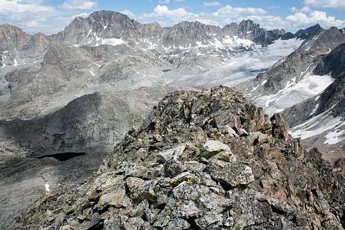
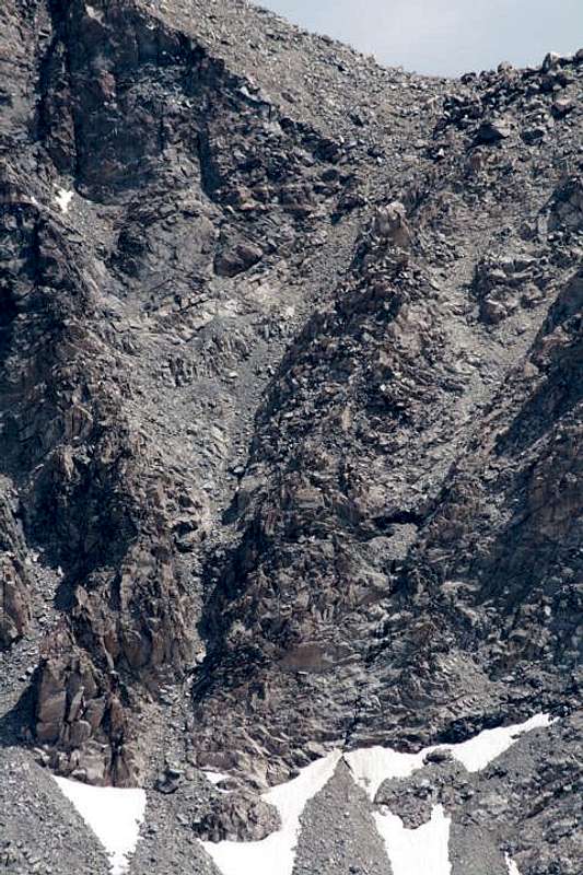
Gannett Peak has a large and spectacular western basin that provides convenient cross-country travel. The glaciers are concentrated on the south and east sides with Mammoth Glacier (upper right) being by far the largest. This view is looking east from Ladd Peak.
Getting There
Like other routes up Gannett Peak, the Southwest Couloir requires a long approach. The closest access from a trail is in the canyon between Peak Lake and Knapsack Col. Peak Lake is accessible via an 18-mile hike from the Elkhart Park, Spring Creek Park, New Fork Lakes, and Green River Lakes trailheads using segments of the Highline Trail and reaching the lake from either Shannon Pass, Vista Pass and Cube Rock Pass, or Vista Pass and Stonehammer Lake. From there follow the Glacier Trail around the north side of Peak Lake and into the canyon toward Knapsack Col. There are several ways to cross over the ridge to the north, but the easiest is the saddle west of Split Mountain. At the upper end of Lake 10,740 leave the Glacier Trail and scramble up to some small tarns and on up the chute to the pass. This requires scrambling over boulders, ledges, and loose rock. In places it is possible to follow the path of past climbers. Small snowfields can be used or avoided in late summer as desired.
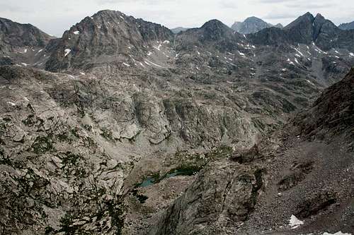
Looking northeast from Stroud Peak is the canyon between Peak Lake and Knapsack Col. Split Mountain is in the upper right and Mt. Whitecap in the upper left. Gannett Peak is in the background right of center. The easiest route is the pass seen in front of Gannett Peak, with access from the canyon in the foreground.
From the pass west of Split Mountain it is necessary to descend and cross the Mammoth Glacier. The descent section is steep and has some bergschrunds and small crevasses that must be avoided. The main glacier is flat and firm, making easy travel in the summertime. Simply head across the glacier toward Gannett Peak, staying at about the same elevation. From the east edge of the glacier cross some small valleys and hills up a gradual grade toward the mountain, which eventually lead to the bottom of a long rockslide interspersed with snowfields below Glacier Pass. Continue a gradual ascent to the north until you reach the base of several nearby couloirs.
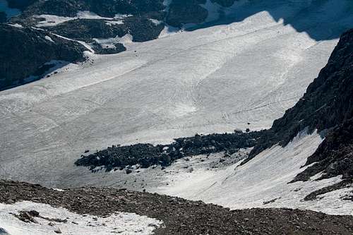
From the pass west of Split Mountain, descend the steep arm of the glacier in the foreground then cross the main Mammoth Glacier.
Another option is to approach this route from Wells Creek or Tourist Creek. Although these routes (accessed from the Green River Lakes Trailhead) are usually used to ascend Gannett's northwest ridge, it is about the same distance to reach the Southwest Couloir. This offers the possibility of a glacier-free approach to Gannett's summit ridge (where traversing the top of the summit glacier is required). From either approach, take the right fork above Scott Lake toward Glacier Pass and the Southwest Couloir between the Minor and Mammoth glaciers. (The author has not traveled this approach from Scott Lake, but it looks uncomplicated.)
No matter which approach you use, take note of landmarks such as snowfields at the base of the couloirs while at a distance so you can identify the couloir you want to ascend. You will not have a birds-eye view once you reach the base of the couloirs, and it is easy to confuse them. (The author reviewed photos on his digital camera to find the base of the desired couloir.)
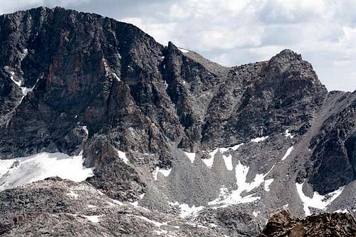
The Gannett summit is on the left, and the South Peak (13,295') and Glacier Pass are on the right. The easiest couloir is the one that leads to the saddle between the peaks. This view is from Mount Whitecap.
Route Description
When dry the Southwest Couloir is a typical loose rock scramble.
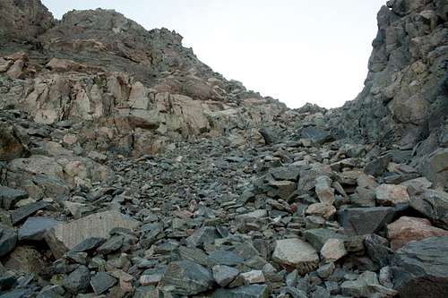
Once you have identified the base of the Southwest Couloir the climbing begins. Be careful of falling rock if traveling in a group. The size of the rocks varies from scree to boulders, but in many places you can choose what size of rocks you wish to negotiate. Some sections can be climbed on bedrock at the side of the chute if desired. The couloir has a narrow section near the bottom with a few chockstones, but they are easy to circumvent.
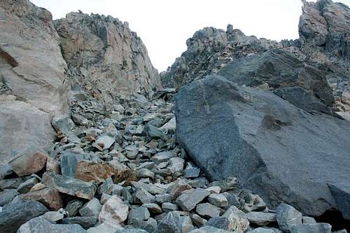
Looking up from the base of the Southwest Couloir.
The slope and terrain remain quite consistent up the chute, which rises 650 feet from the base to the saddle.
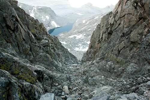
Looking down the Southwest Couloir at Lake 11,598 and Mammoth Glacier.
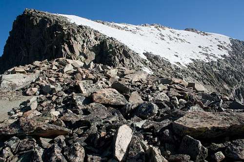
In July of 2013 there was virtually no snow in the couloir, but this will vary from year to year, so be prepared.
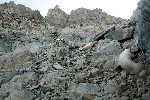
This was the only snow in the Southwest Couloir in late July of 2013 (right side).
The slope of the chute gradually decreases toward the top, which leads to the saddle near Gannett's south peak (13,295).
From the saddle you can look down the Southeast Couloir on the other side and take a side trip to the south peak if desired. Climb the gentle rocky slope to the north to reach the trail that most climbers use when ascending from the Gooseneck Glacier. From there traverse the snow and rock north along the ridge to the summit. Return can be made by the same route. (The author has only ascended this route.)
Looking north at the summit ridge and glacier of Gannett Peak. Behind the notch at the left is the top of the next couloir to the north. The summit is in the upper right.
Essential Gear
A helmet, ice axe, and crampons are strongly recommended because of the steep, loose rock and the likely crossing of glaciers and snowfields. Warm clothing and rain gear should be carried because of the frequent storms that hit the Wind River Mountains, especially in the afternoons. Other gear will depend on the access route and the proximity of camp.
External Links
Joe Kelsey, in Climbing and Hiking in the Wind River Mountains (2nd ed., 1994, Chockstone Press, p. 124), mentions the "West Face/South Ridge" as follows: "From Mammoth Glacier several routes have been used to reach the South Ridge near its junction with Gooseneck Ridge. Apparently both prominent couloirs have been ascended. One climb was by 17-year-old Yvon Chouinard, on his first mountain."
Ron Adkinson, in Hiking Wyoming's Wind River Range (1996, Falcon Guides), provides descriptions and maps of trails into the area, as does Kelsey.
summitascender - Jan 11, 2014 2:09 am - Hasn't voted
Different ApproachI have done this route on two seperate occasions. On both occasions we approached it from Tourist Creek, up to 11,085, and down into Scott Lake Basin. I would recommend this approach over the approach described herein. Although the description provided is certainly another approach.
kteichert - Jul 1, 2017 1:44 pm - Hasn't voted
Re: Different ApproachFrom what town do you approach Tourist Creek? On Google Maps, I see a faint trail/road that follows Green River to Tourist Creek. But how do you get there?
skidoo1066 - Feb 8, 2018 4:38 am - Hasn't voted
Re: Different ApproachFrom Pinedale/Cora you head north then the road wraps south to the Green River Lakes Trailhead. https://goo.gl/maps/GwqpDRX2do92 You follow this trail about 10 mi then bushwack to go up Tourist Creek.