|
|
Route |
|---|---|
|
|
43.18440°N / 109.65429°W |
|
|
Mountaineering |
|
|
Summer |
|
|
A few days |
|
|
Overview
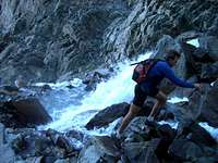
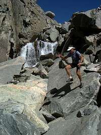
The Tourist Creek and Wells Creek routes access Gannett's spectacular and seldom-visited west face. These are long and difficult routes, covering roughly 18 miles from the Green River Lakes trail head to the summit. For Wells Creek, the first 12 miles or so are on the easy Highline Trail, but after that there is no trail and very little easy hiking. Once you head up Wells Creek from the Highline you will encounter steep rock hopping and, in mid-summer, one pitch of mid-5th class rock climbing. If the creek is low enough to cross at the critical point, such as perhaps in late summer or fall, you might be able to bypass the rock climbing.Getting There
From Pinedale, head west on US-191 for 6 miles and turn right (north) on WY-352. Follow WY-352 for 44 miles to the Green River Lakes trail head. There is a campground and water at the trail head, as well as overnight parking for backpackers.Route Description

Now the fun begins. First you must navigate some dense woods. Then, rock hopping and scrambling starts in earnest as the drainage steepens. While tough going, the climb is very scenic as you ascend into a dramatic valley, and are often climbing right over the creek.


Above the Cleft, continue rock hopping and you will soon come to the upper Wells Creek drainage, at the west end of Many Bug Lake. Here the grade flattens for a while, but there is still more rock hopping to traverse around the right (south) side of Many Bug Lake. Next you encounter Scott Lake, at 10,515', as Gannett's dramatic west face looms above.
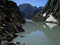
Continue around Scott Lake (north side is probably best), and climb east up the main drainage to a long, skinny lake at 10,795'.
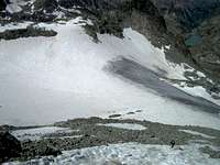
At this point you can see Gannett's west face and the upper part of Minor Glacier that you will be climbing. A prominent finger of snow heads towards the summit from the main part of the glacier. You will ascend this couloir to a talus field climber's left of the top of the snow.
But first: two drainages feed the skinny lake at 10,795'. Pass the lake on either side and ascend the drainage on your right (more rock hopping and scree). At the top of this drainage you will encounter Minor Glacier. Ascend the glacier and the couloir which gradually steepens to maybe 40 degrees. You might be able to skip avoid some of the snow by climbing rock on one side or the other. At the top of the couloir, head climber's left to get on some loose, unpleasant talus. Continue up to the rugged north ridge of Gannett.
Once on the north ridge, work south towards the summit, ascending class 4 rock. This is fun climbing and not super exposed. A couple of rappel stations have been rigged in recent years for the descent. The rock ends with a short walk across snow to the summit.
Return the way you came!
Essential Gear
sticky rubber approach shoes for all the rock hopping & climbingtrekking poles would help
crampons & ax
whatever gear you require to ascend & descend about 100' of 5th class rock, up to about 5.6
map: Earthwalk Press "Hiking Map & Guide: Northern Wind River Range, WY"
strong quads and a sense of adventure