
-
 4313 Hits
-
 78.27% Score
-
 9 Votes
|
|
Route |
|---|---|
|
|
49.73753°N / 125.49213°W |
|
|
Hiking, Mountaineering |
|
|
Half a day |
|
|
Class 3 |
|
|
Overview
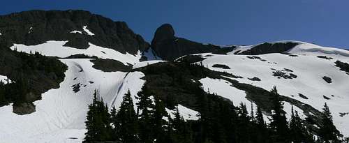 Alexandra Peak west bowl Alexandra Peak west bowl |
Reaches the west bowl under Alexander’s summit cliffs from the west ridge via a steep bushwhack up to the west ridge and along the ridge until it peters out in the bowl.
Once on the shoulder south of the summit block traverses the east side of the "Thumb" to a notch and up to the top from there.
Getting There
From Campbell River at the end of the freeway section of Highway 19 and take highway 28 west towards Gold River. After 47 km you will enter Strathcona Park at Elk Portal. Exactly 1 km further on highway 28 makes a right turn over the bridge at Buttle Narrows. Ignore the turn and carry straight on down the paved Buttle Lake Parkway (also known as Westmin Mine Road) for ~ 10 km and find “Buttle Bluffs Road” on the left at N49 45.899 W125 35.048 – about 400 metres south of the Lupin Falls day use area.Keeping right and/or uphill at any junctions, drive the steep and narrow road about 7 km southeast and up to the junction of two high hanging valleys with logging roads everywhere. One branch of the valley turns southeast down towards Pearl Lake and the other northeast, up towards the high pass between Alexandra Peak and Mt Adrian from where Alexandra Creek drains the mountains east and down to the Oyster.
Take the left hand fork labelled “Prk 300” and drive the remains of the road as high as you can towards Alexandra and Adrian. From the valley junction on some severe washouts are currently (July 2010) apparent. My 4Runner made it a further ~ 1.5km to 1,200 metres elevation before reaching the limit of its capabilities but we noted that others had made it further.
WARNING
“Buttle Bluffs Road” is not for the faint of heart. Particularly in the upper reaches it’s extremely steep, narrow due to rockfall and is beginning to slough off in places. Don’t try to drive it alone. A “spotter” is essential to guide you through some spots which were just wide enough to get my 4Runner through with the near side wheels on the last few inches of road overhanging the 1,000 metres drop to Buttle Lake below.
Route Description
Although the west bowl may be reached directly by climbing snow in the main gully that runs almost directly up from Prk 300, this is unlikely to present a year round option particularly in conditions when the snow is undercut by running water.A safe, albeit bushy alternative, proceeds as follows. There are currently no cairns or other markings on this route until it joins that from the Oyster River approach on the south shoulder.
Drive or walk to the end of a spur that branches to the right off Prk 300 at N49 44.096 W125 31.406. The end of the road is at N49 43.950 W125 31.222 where the old growth comes down to the end of the road with the southwest ridge above. Starting elevation is about 1,200 metres.
 Route start Route start |  Exit to west ridge Exit to west ridge |  Upper access gully bush Upper access gully bush |  Lower west ridge Lower west ridge |
Cross the gully and enter the old growth on climber’s right side. Follow falling boundary tape at first east until you’re above the limit of logging to the north (which you can’t see). Some open friendly angle bluffs lie above reasonably open forest before you’re forced briefly back into the gully proper. After 5-10 minutes more reach a branch in the gully. That to the right looked to be a dead end. Instead go left up steep and bushy ground with the gully wall on your immediate right and out onto open ground on the ridge crest at about N49 43.995 W125 30.696 and 1,600 metres elevation.
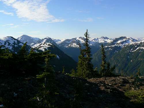
View SE from west ridge
Follow the ridge round to the west bowl below the main peak and Thumb.
 South shoulder access South shoulder access |  Thumb traverse Thumb traverse |  Descending summit block I Descending summit block I |  Descending summit block II Descending summit block II |
Traverse the bowl east until you’re south of the Thumb. Choose any suitable line that takes you up to the south shoulder. In early season there is likely only one way up; midway between the steep gully between the main summit and the Thumb and the corniced cliffs to the south.
From the south shoulder traverse around the east side of the base of the Thumb and drop into the notch below the main summit on quite exposed ground.
Climb out of the notch northwest and up ledges and gullies with a little Class 3 here and there to the main summit.
Route summary:
Distance: ~ 7 km
Net elevation gain: ~ 700 metres
Total elevation gain: ~ 800 metres
Approximate time: 7-8 hours return
As always a Garmin/Mapsource tracklog is available for the approach and climbing route on Alexandra Peak. Just ask for it via an email or PM.
Essential Gear
Ice axe and, perhaps, crampons for the last pitch up to the south shoulder from the west bowl.Camping, Weather, Links, Red Tape, Safety etc
Please refer to the parent mountain page.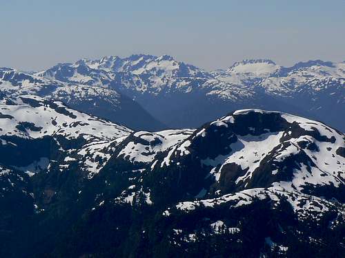
View SW from the summit of Alexandra Peak