
-
 3193 Hits
-
 73.06% Score
-
 3 Votes
|
|
Route |
|---|---|
|
|
42.83280°N / 0.2906°W |
|
|
Download GPX » View Route on Map |
|
|
Mountaineering |
|
|
Spring, Summer, Fall |
|
|
A long day |
|
|
5.2 (YDS) |
|
|
P.D.inf. |
|
|
II |
|
|
Overview
See main pageGetting There
A little road joins Sallent de Gállego with the reservoir of La Sarra where we leave the car (3.5 km).Approach to Mountain Hut of Respomuso from La Sarra (2h 30min): We cross Faxas's bridge we will pass the reservoir up to a way that enters the valley towards the ibón (lake) and mountain hut of Respomuso across a beautiful forest of beeches and the narrow Paso (pass) de l'Onso. We come to a level zone (Llano Cheto, 40-50 min) to continue for new slope up to the most top part of the valley. On the west we see the wall of the prey of Respomuso's dam where we go. After leaving behind the house of the hermitage of Ntra Sra de las Nieves (St Mary of the Snow) we come to the refuge.
Route Description
 Sketch
 First chimney
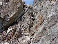 Second chimney
 Final climb
 Climbing summit
From Refugio de Respomuso we take the path with signal a few of meters in the route that we followed the previous day. We walk across steepy slopes with grass and rock to reach an upper part with a signal to Frondellas on left side but we follow the cairn of right side waling under the big wall of ridge Le Bondidier. In direction W-NW is the access to the Brecha Latour (Latour's break). On left side we can see Aguille Cadier, a rocky peak at left side of Brecha latour. we leave the route to Brecha and Balaitous and we walk in direction of the evident cut in the wall under the peak. With snow it's necessary the use of crampons and ice-axe (35º). We climb to the entry of the chimney (II) and we turn to left climbing the terraces (II-). We turn to left following across a new chimney (II-) exiting to a big terrace between Frondellas North (left) and Aiguille Cadier (right). We walk to front searching the end of the ridge of aiguille reaching a very small gap crossing to the other side and climbing the nice but exposed wall (II-) of Aiguille Cadier (3.022 m ). We return to the col with Frondellas North and we turn to left side of this peak following with attention the cairn entering to the East face. We reach a point with an evident channel on left side to climb (I+) to the ridge of Frondellas North turning to left to climb the summit (3.062m). We back to the ridge following (I+) to main summit (3.071m) with mailbox. The ridge is easy now walking to reach a small block (I+) that we descent to walk now to Frondellas Central (3.055m). We continue to south to an presummit and we leave the ridge following the cairns among the stones to right side descending to reach a small and curious terrace that it goes to left to exit of the ridge with view of Frondellas SW (we climb this peak across its normal route if you want). We descent across the route of Lakes of Arriel