
-
 11362 Hits
-
 81.84% Score
-
 14 Votes
|
|
Mountain/Rock |
|---|---|
|
|
42.83280°N / 0.2906°W |
|
|
Download GPX » View Route on Map |
|
|
Mountaineering |
|
|
Spring, Summer, Fall |
|
|
10075 ft / 3071 m |
|
|
Overview

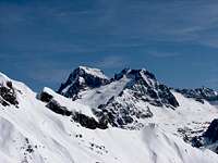 Frondiellas & Balaitous
Frondiella or Frondella is one of the most important peaks of the massif of Balaitous but it's less height does not have the well-deserved reputation of its great brother that's nearby less than 1 kilometre. The peaks appear both inevitably from many parts of the Spanish Pyrenees. Only from the north face in France the Balaitous there prevents the vision of this peak. The best view of the great peak of Balaitous and many mountains that surround it it's obtained from the summit of Frondiella.
A great difference between both peaks is the aspect of the top, the colossus Balaitous is very wide but the Frondiella is indeed a set of 4 summits joined for elegant ridge. For this reason often there is used the word Frondiellas or Frondellas (plural) to refer to the mountain.
The connection between both tops is a ridge scarped with a great crack in the central part, the Brecha Latour, which supposes the most common, but not easier, route to climb the Balaitous.
The list of the summits of Frondiellas is from NE to SW:
-Aguja Cadier or Pico Anonimo (3.022m)
-Frondiella North (3.062m, very secondary summit in the ridge with the Ag.Cadier and Brecha Latour)
-Frondiella (3.071m, or Eastern Frondiella, the real summit)
-Frondiella Central (3.055m)
-Frondiella South West (or south, 3.001m or 2.998m, main summit of southwestern side, I will write a page about this peak because the route is different).
The ridges between the summits:
-Aguja Cadier: II, exposed. I+ to North summit.
-North to main: I+, narrow.
-Main to Central: I+, very wide.
-Central to SW: III, breaks, descent (even rappel advisable), narrow.
-Normal route of Frondiellas SW: This peak has a normal route across its West face of grade II.
 |  |  |  |  |
Aguja Cadier or Pico Anónimo (3.022m)


It's the fith Frondella topographically but it's the peak that constitutes Brecha Latour with Balaitous and it has a different name remembering the climbers brothers Cadier (they were five famous climbers).
 |
 |
 |
 |
Frondellas Norte (3.062m)


Norte=North. It's a secondary summit in the ridge with the Ag.Cadier and Brecha Latour but it's probably the peak with better panorama.
 |
 |
Frondellas Central (3.055m)


It's a secondary summit in the ridge between the 2 main summits and it's a step forced for two of the routes of this mountain.
Routes
Two important routes to climb this mountain, both in the spanish side from the dam of La Sarra (height to gain of 1631 meters):-Normal route (easiest): lakes of Arriel (F+, 5h30min).
-Respomuso-Spun Ledormeur (P.D.inf., some shorts steps of II or II-, 5h 30min, or 3h and 900 meters of height to gain from the refuge of Respomuso).
-Respomuso-Aguja Cadier: (P.D.inf., II to aiguille and I+ to Frondellas North and main summit.
The complete route of the ridge of Frondiellas includes the ridge to the western peak (III, AD) after the climb of the Central and the main summit. It generally needs a rope (rappel advisable). If you want climb this peak it's better a little descent to the route of Lake of Arriel and take the bottom of the ridge and it go from there to this summit.
The mountaineers generally climb this mountain across the spun Ledormeur (or even the most expert across the ridge Le Bondidier) because it's most direct and the route of Lakes of Arriel it's a little more heavy with a lot of stones (this is the route of descent for both routes). For the people without experience in chimney-climb of grade II you must follow the normal route.
 |  |
Getting There
To approach to La Sarra and refuge of Respumoso you can consult the pages of Balaitous and route of Respumoso of Picos del InfiernoRed Tape
No permits required.When To Climb
 Pallas-Frondiellas
June to september. Early in the season (may-june) the routes had still a lot of snow.
 |  |
Camping
Camping and vivac are permit in the distance of the refuges. A nice and marvel place for the tents are the Lakes of Arriel if you climb for this route. In the route of Comba Vallot the normal sleep is in the great refuge of Respumoso (Tel: 974-490203, 105 persons).In the french side is the refuge of Larribet (Tel:05-62972539, 60 persons) but the route is long for this mountain across the Port of Lavedan (near the peak Palas) or the Col Noir of Balaitous.
Rafa Bartolome - Oct 24, 2004 11:50 am - Hasn't voted
Untitled Commentlo que pones es correcto y sigue mostrando lo dificil que es acertar con las alturas de las montañas. Ya habrás visto que según mi GPS (y el de otros) el Balaitous tiene 3151m por mucho que se empeñen en quitarle 7 metros (ningún GPS comercial tiene tanto error, máximo 3-4 metros gracias a los nuevos satélites y el EGNOS en cimas despejadas). Yo te puedo decir que en Frondiellas coincido en que me indicaba 3069 o 3070 el principal y 3055 el central (otras medidas que he tomado este año me daban 3406 en Aneto, 3353 en Perdido y 3222 en Perdiguero, o sea que el error ronda los +/- 2-3 metros). Los mapas de Alpina son muy buenos en las curvas de nivel pero las alturas no tanto por lo que parece (14m de diferencia la central es mucho). Los otros 2 Frondiellas no he subido. Es sorprendente el pedazo de error del IGN francés que le quita nada menos que 30 metros a la central. Creo que el IGN español es el más acertado hoy por hoy y que es el que suele usar M.Angulo en sus libros y mapas del Pirineo, lástima que no sea fácil conseguir los datos sin pagar. El IGN es el único junto con los mapas del ejército que dice que Balaitous tiene 3151m en contra de la lista oficial de tresmiles. Seguiré investigando este tema pero no creas que somos los únicos que se equivocan, si te cuento los errores del mapa del IGN de Perú que tengo de la quebrada de Ishinca... hoy por hoy hay aparatos muy sensibles (y caros) con precisión absoluta que usan los gobiernos y topógrafos que sacarían de dudas sin muchas problemas (sólo subir a la cima claro)
Diego Sahagún - Oct 24, 2004 7:07 pm - Hasn't voted
Untitled CommentBueno, al Monte Perdido le da el IGN español 3.348 m pero yo también creo que son más fiables los 3.355 por mediciones con mi altímetro (no tengo GPS). Al Aneto el Ejército le da 3.408 m y al Perdiguero 3.221, igual que Alpina. Claro que al Perdiguero el IGN español le da sólo 3.203 m. Estos desfases para mi también son injustificables. Este verano subí a la Tusse de Remuñe (3.041 m según la lista oficial de tresmiles del Pirineo) y cual es mi sorpresa cuando descubro que el IGN español le da sólo 2.971 m ¡Una diferencia de 70 metros entre una medición y otra! ¿A quién hay que creer? Por cierto, que tu te quejas de las mediciones de Alpina, pero al Balaitous le da 3.151 m, por 3.146 el Ejército.
Rafa Bartolome - Oct 25, 2004 10:59 am - Hasn't voted
Untitled Commentbueno, todos los mapas fallan en algún monte. A mí me gustan mucho los mapas de Alpina modernos (los antiguos era otra historia), no me había fijado que ponía 3151 el Balaitous ya que no tengo el de esa zona de Alpina, pero es un monte que sirve de referencia para saber de donde sacan los datos ya que la mayoría ponen lo de siempre sin comprobar un poco. Alpina además de mejorar los mapas al salir más claros y legibles actualmente con ordenador es de los pocos que ha empezado a editar los mapas para GPS en CD calibrado para oziexplorer aunque son un poco caros (8euros el Cd cuando por ese precio lo compras en papel y lo escaneas para calibrarlo tu mismo). En Peña Castil el de Alpina es el único mapa que he incluido en la página sobre Picos de Europa aunque haya otros de más resolución pero no tan claros y bien trabajados.
Al final habrá que ir subiendo todos los montes y comprobar en persona con el GPS pero un desfase de más de 10 metros no es admisible en pleno siglo XXI
Diego Sahagún - Oct 23, 2004 9:03 pm - Hasn't voted
Untitled CommentFrondiella (3.071 m) is also called Pico de la Frondella. Frondella means closed mountain. Another height of the mountain are 3.068 m by Editorial Alpina.
Frondiella North (or Norte) (3.062 m) is also named Frondella Norte. Another altitude is 3.057 m by the Spanish IGN.
Frondiella Central (3.055 m) is also called Frondella Central. Other heights are 3.069 m by Editorial Alpina and 3.025 by the French IGN.
Frondiella Western is also named Frondella SW (or SO) (3.001 m). Another elevation is 2.995 m by the Spanish IGN.
Diego Sahagún - Oct 24, 2004 7:07 pm - Hasn't voted
Untitled CommentBueno, al Monte Perdido le da el IGN español 3.348 m pero yo también creo que son más fiables los 3.355 por mediciones con mi altímetro (no tengo GPS). Al Aneto el Ejército le da 3.408 m y al Perdiguero 3.221, igual que Alpina. Claro que al Perdiguero el IGN español le da sólo 3.203 m. Estos desfases para mi también son injustificables. Este verano subí a la Tusse de Remuñe (3.041 m según la lista oficial de tresmiles del Pirineo) y cual es mi sorpresa cuando descubro que el IGN español le da sólo 2.971 m ¡Una diferencia de 70 metros entre una medición y otra! ¿A quién hay que creer? Por cierto, que tu te quejas de las mediciones de Alpina, pero al Balaitous le da 3.151 m, por 3.146 el Ejército.
Rafa Bartolome - Oct 25, 2004 10:59 am - Hasn't voted
Untitled Commentbueno, todos los mapas fallan en algún monte. A mí me gustan mucho los mapas de Alpina modernos (los antiguos era otra historia), no me había fijado que ponía 3151 el Balaitous ya que no tengo el de esa zona de Alpina, pero es un monte que sirve de referencia para saber de donde sacan los datos ya que la mayoría ponen lo de siempre sin comprobar un poco. Alpina además de mejorar los mapas al salir más claros y legibles actualmente con ordenador es de los pocos que ha empezado a editar los mapas para GPS en CD calibrado para oziexplorer aunque son un poco caros (8euros el Cd cuando por ese precio lo compras en papel y lo escaneas para calibrarlo tu mismo). En Peña Castil el de Alpina es el único mapa que he incluido en la página sobre Picos de Europa aunque haya otros de más resolución pero no tan claros y bien trabajados.
Al final habrá que ir subiendo todos los montes y comprobar en persona con el GPS pero un desfase de más de 10 metros no es admisible en pleno siglo XXI