Hiking Ruby Mountain... The Old-Fashioned Way
I had been wanting to summit
Ruby Mountain, in the North Cascades of Washington, for quite some time, mainly because I knew the mountain is the 21st-most prominent peak in Washington and would not require too much technical effort to summit. However, I preferred to summit via the original long approach, via the old Ruby Mountain Trail from Fourth of July Pass, rather than the much shorter snowy ascent option of the northwest ridge than many mountaineers prefer. I had been very busy this summer doing hikes, working, and other things, but the week's earlier storm system that struck western Washington made me realize how fast summer was disappearing. Before long, the higher peaks (especially peaks in the North Cascades) would have snow again.
I had Friday off from work, but my friends did not. The weather conditions were supposed to be very good, although my friends were all working. I would have to make a solo attempt of Ruby Mountain, which was fine with me despite its 18-20 miles roundtrip of hiking involved. I was in good physical condition, and I had done plenty of research on the peak and route. Carrying a trusty vial of pepper spray, and with my hunting knife at my side, I tried being prepared in case of any cougar encounters. I left my house at 3:00 AM, stopped at a rest area for a one-hour power nap, and arrived at the Colonial Creek Campground/ Thunder Creek Trailhead by 6:30 AM.
![Ruby Mountain]() Ruby Mountain, as seen from Highway 20 west of peak...
Ruby Mountain, as seen from Highway 20 west of peak...![Ruby Mountain]() Ruby Mountain, as seen from Thunder Creek Trail...
Ruby Mountain, as seen from Thunder Creek Trail...![Crossing Thunder Creek]() Crossing Thunder Creek...
Crossing Thunder Creek...
I planned for a long one-day hike, although I had a bivy sack and enough food in case of an emergency overnight stay was needed. The first 1.5 miles of Thunder Creek Trail were fairly uneventful, until I encountered a man standing on the bridge crossing over the water. He said he was out on an early morning hike, but had no clue where he was going. I told him about my destination, as well as Fourth of July Pass and Panther Potholes. He opted to continue following Thunder Creek Trail instead of heading towards Fourth of July Pass like I was doing.
The key to my success would be finding the old Ruby Mountain Trail, which is an unofficial route leading up the south ridge of the peak. I knew that Panther Creek Trail was closed east of Fourth of July Pass, due to a summer wildfire in the area, so I had contacted the Wilderness Center in Marblemount on Thursday afternoon to ask if I could at least follow Panther Creek Trail to the Ruby Mountain Trail and then follow that route to the summit. The response: "You are more than welcome to do that... assuming you can even find the trail." Then the ranger giggled... certainly not an encouraging sign. I said I wanted to do the trek as a day-hike, and the ranger said that is what most people do. Again, a snicker followed, and I wondered what unforeseen things awaited me. Fortunately, I had already known about the "hidden" Ruby Mountain Trail and I had been aware of the general location (but not exact location) where it started at/near the Panther Creek Trail.
After I hiked across Fourth of July Pass, passing Fourth of July Camp and Panther Potholes, I found my clue... an otherwise insignificant 30'-long wooden "bridge" along the Panther Creek Trail. About 50' west of (i.e. before) the bridge, just beyond a tiny grassy/marsh spot, I found a well-defined path (~3600' elevation) slightly north of the Panther Creek Trail. Within 100 yards or so, the path passed a sign marked "TRAIL ABANDONED - NO LONGER MAINTAINED". Having already known about that sign, I knew I was on the right trail. Despite some deadfall and newer forest growth, the beginning of the trail was easy to follow. However, by ~3900' elevation, the trail became consumed by deadfall and seemed to disappear. I spent a some time trying to retrace the path, but I opted to continue straight up the south ridge rather than waste a lot of time searching for an unmarked/seldom used path. Hiking up the mountain without a trail, occasionally stopping to look for spots that seemed most feasible for a path to be, my hiking time slowed down.
![Ruby Mountain Trail]() All I am missing is a "double dare"...
All I am missing is a "double dare"...![Ruby Mountain Trail]() Trail? What trail?
Trail? What trail?![Ruby Mountain South Ridge]() Looking down south ridge from summit ridge...
Looking down south ridge from summit ridge...
Noticing some minor gullies and rockfaces slightly east of the south ridgeline, I continued up the middle of the ridgeline, or occasionally just slightly west of it. I kept hoping to re-encounter the original Ruby Mountain Trail, but as I hiked steadily up the mountain I began to have my doubts. Then, at ~4950' elevation, I hiked atop a small open rocky spot that had a small cairn on it. Looking ahead, I could see a path. Woohoo! From that point on, the Ruby Mountain Trail was relatively easy to follow... despite occasional deadfall and forest growth. At approximately 6000' elevation, the trail entered a steep meadow slope. The trail proceeded to switchback up the meadow slope until ~6600' elevation, when it seemed to once again disappear. I opted to hike straight up the steep dirt & talus slope ahead of me to the summit ridge. Once on the summit ridge, I turned left, passed over a minor highpoint, and proceeded to the true summit (7408' elevation). An antenna was there, but I was saddened to not see any summit registers. Oh, well.
![Ruby Mountain Summit]() Looking north to true summit...
Looking north to true summit...![Ruby Mountain Summit View]() Nice view southwest of summit...
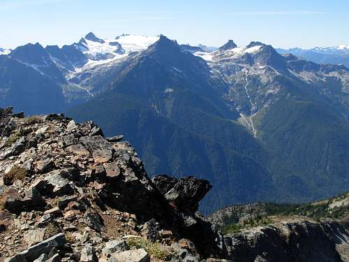
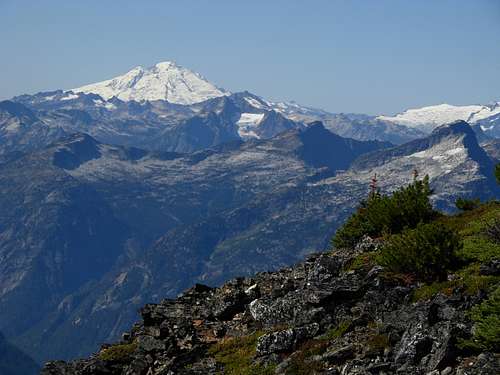
Nice view southwest of summit...![Ruby Mountain Summit View]() Nice view of Mount Baker from summit...
Nice view of Mount Baker from summit...
The views from the summit were SPECTACULAR. In my opinion, the Ruby Mountain summit has the best views of other North Cascades peaks than any other mountain I have been to so far. I highly recommend this summit. After spending 30 minutes at the summit, taking photos and having a snack, I headed down. The trail was fairly easy to follow until that 4950' elevation spot where it seemed to appear during my ascent, and then I was unable to re-trace the trail until ~4000' elevation. Fortunately, I had been keeping waypoints and a track log the entire way. My descent route was not exactly like my ascent route, but I managed fine with my GPS and map.
![Ruby Mountain Summit View]() View of Ross Lake from summit...
View of Ross Lake from summit...
Knowing how much daylight remained, I took my time on the way back to enjoy the scenery and visit Panther Potholes. When I crossed back over Thunder Creek, I noticed that park rangers had attached a memo to the bridge during that day while I was on Ruby Mountain. The memo explained that there had been many recent encounters with cougars in the area and to use caution. Fortunately, I had no such encounters on this trip. I arrived back at my car by 6:00 PM, which was sooner than I had planned. I had originally thought of hiking some other North Cascades peaks the following day, but my early return made me think it would be nice to surprise my wife that night and spend time with her instead. She appreciated the consideration.
Comments
No comments posted yet.