
|
|
Route |
|---|---|
|
|
19.01640°N / 97.2667°W |
|
|
Arduous but basic snow/Glacier climb |
|
|
One to two days |
|
|
Class II-III |
|
|
Approach
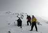
You have to arrange transportation from El Ciudad Serdan, Esperanza or Azitzintla for the drive up to the refugio on the southside of the mountain past the saddle it shares with Sierra Negra. The drive up to the reufgio can be made without a 4x4 or even a 4x2, but it takes a very competent driver (and some strong backs) as the road in places is VERY rough. When we drove up we had to get out and push and places large rocks under the wheels for greater traction... nothing too crazy but exerting yourself like that at altitude is a whole different game.
There is a parking area around 4250m where one can leave their vehicle and hike up.
It is also posible to hike the whole way up (to the refugio) and rent teams of burros, I have no idea how long this would take, but it would be considerably more time consuming and taxing, but would perhaps allow more for acclimitisation if that is an issue. The hike alone from Azitzintla takes between 6-9 hours depending on one's level of fitness.
 |  |  |
Route Description
This is a variation of Ruta Sur... but varies enough to warrant its own page. This is the most challenging and direct route to the summit on El Pico's southern side.
It is steeper, more sustained and more exposed than Ruta Sur. In places approaching 50 degrees or more. Allow for between 5-8 hours on the top... depending on your condition and of course the weather conditions.
Be prepapred to don crampons anywhere between 5100-5300m depending on the snow conditions, when I climbed this route there was between 1-2 meters of snow which for Orizaba's southern slopes is a lot.
From the Fausto Gonzales hut at 4660m you make your due south until you come out at the foot of the mountain near the top of the ridge that towers over the refugio to the west.
Move westwards until you encounter the spine and then start making your way up over the mountain's southern spine staying to the west of the pulpito. As you approach the pulpito move to the east (left) around it and then onto the summit.
For the most part stick to the rock bands and when above 5400m stay slightly to the west of the pulpito.
 |  |  |
Essential Gear
You will need to bring all necessary cold weather and rain gear as the weather on any given day will throw a little bit of everything at you. I would suggest at least 5l of water per 24 hours spent there to aid with acclimitisation.
Sun glasses and a sun block with an SPF of at least 45... be sure to re-apply, I made that mistake once and learned the harsh consequences of forgetting.
An ice axe and crampons are mandatory, also rope, a harness and a locking biner would also be very useful. The route is realtively steep and sustained for much of the climb.
I would suggest that you should know how to self arrest and even basic avalanche awareness will help... both of these were necessities when I climbed. Look for fractures in the snow which can signify potentially hazardous areas.
Trekkiing poles are also a good option on the way up... and a set of dry clothes for after the climb is also a very good idea.
 |
Miscellaneous Info
If you have information about this route that doesn't pertain to any of the other sections, please add it here.