
-
 8018 Hits
-
 79.78% Score
-
 11 Votes
|
|
Route |
|---|---|
|
|
38.02010°N / 105.1162°W |
|
|
Download GPX » View Route on Map |
|
|
Hiking |
|
|
Spring, Summer, Fall, Winter |
|
|
Half a day |
|
|
Overview
 Rolling across the false summit, summit in the distance
This is a mellow walk-up route allowing for a gentle amble through the woods to an open summit. The vast majority of the route is all on-trail, with only a short jaunt to the grassy summit requiring any off-trail work. The route weaves through gurgling drainages and shady, mature forest but provides for two spots for wide-open views (the sub-summit and the summit proper of Saint Charles Peak). This is an excellent route to save for snow season: Ample snow in the area makes for excellent snow-shoeing or skiing and there are no motorized recreational vehicles to contend with (as will be the case in summer). Any road noise from Hwy 165 is soon left behind for a walk in the hushed wilderness.
Roundtrip Distance: About 9 miles
Elevation Gain: 3,100 feet
Time Allowance: About 3.5 hour moving time at moderate pace
YDS Class: 1+ (due to easy off-trail to gain summit)
Getting There
 Small parking turnout
 Typical trail conditions
Note: You can also wriggle the backroads through Wetmore and approach this trailhead from the north. The below directions are simpler, however, so I will provide them here for those less familiar with this area.
• Take I-25 to Exit 74 (Colorado City).
• Head west on Hwy 165.
• The trailhead is on the west side of the highway and is difficult to spot. Parking is on the east side of the highway, consisting of a small turnout with diminutive signage.
• The trailhead is less than 2 miles south of Bishop Castle. Thus, if you are approaching the trailhead from the south and reach the Castle, you have gone too far.
• In total, expect to drive 22 miles from I- 25 to the trailhead.
Route Description
 Snow shoe trench
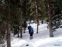 Descending into the middle valley
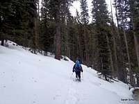 Ascending out of valley
 Heading up toward high saddle
• Carefully cross to the west side of the road to locate the trail, just slightly to the south of the parking area.
• The trail begins climbing gently through dense forest, weaving across a small drainage in a generally southwestern direction, before beginning to switch-back up to a gentle saddle (approximately 10,100 feet).
• The route drops about 100 vertical feet into another drainage into dense timber and travels west-northwest up the drainage. It then begins switching back out of that drainage and turns southward up a hillside.
• At roughly 3.0 miles from the trailhead, reach a higher saddle (just below 11,000 feet). In winter conditions, this is a good place to ensure your windproof gear is locked and loaded.
• From here, the trail heads southward to climb first the false summit. After strolling up and around the false summit in the open, the trail briefly re-enters the trees crossing over toward the summit.
• The trail turns sharply to the west and exits the trees again into an opening before arriving at the base of the summit. Leave the trail and head south-southeast to the summit, marked by a small tower and structure.
 Ascending false summit
Essential Gear
 Trail around false summit
• Map & compass
• Comfortable hiking boots or shoes
• Snowshoes or skis after a heavy snowfall
• Water and snacks
• A camera to save memories of the high country views
• First aid kit
• Other standard backcountry essentials
 Last push to top Last push to top |  Mellow trail Mellow trail |