
|
|
Mountain/Rock |
|---|---|
|
|
33.17072°N / 111.70567°W |
|
|
Download GPX » View Route on Map |
|
|
Maricopa |
|
|
Scrambling |
|
|
3104 ft / 946 m |
|
|
Overview
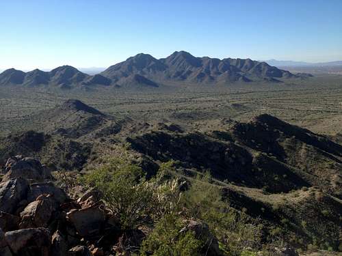
San Tan Mountain High Point as seen from Goldmine Saddle
Oddly enough, the high point of the San Tan Mountains is unfortunately not contained in the San Tan Mountain Regional Park. Although rarely patrolled, the mountain is apparently illegal to climb as it lies on Gila River Indian Reservation Land. (Credit: surgent) This page is here for those who see this mountain and are curious to know why there is no information to be found on it, etc.
Those wanting to attain this summit have to travel cross country from West of the Park. Multiple people have attained the summit in recent years by starting south of Hunt Highway going down either Wagon Wheel Road or Bell Road. There is a summit register on top that says "San Tan Mountain".
Peakbagger links to those who have attained the summit: http://www.peakbagger.com/peak.aspx?pid=4140
There is no trail to the summit---this is a cross country affair dodging all multitudinous Cacti with a Cactus infested class 3 scramble to the summit where you may encounter Killer Bees. Javelina wild boars are also in the area.
GPX File to the summit is available to download above.
Anyone with pictures or more info please feel free to add!
![End of Bell Rd parking area with White Gate]()
End of Bell Rd parking area with White GateFrom Hwy 60 (Superstition Freeway), take the Higley Road exit and drive south on Higley road as far as it goes and turns in to Hunt Highway. From Hunt Highway, go East past Power Rd until you see Bell Rd as your 2nd right after power and turn right on Bell Rd. Follow Bell Road until the road turns to dirt and there is a white gate shortly afterward. Start your cross country trek from there!
For those that want to start at an official trailhead and take on more mileage, you from the Dynamite trailhead and follow the trail for a bit until starting the cross country from there.
![Screencap of Route from GPS Data]()
Screencap of Route from GPS DataStart at the end of either Bell Road or Wagon Wheel Road and route find your way almost directly west to the summit. It's pretty easy to see your target and find your way. The attached GPX file can help guide you. Staying farther north and going up the draw to the north and east of the peak to the summit is the better option than going past and coming up from the south although both work.
From the parking area at the very south end of Bell Road, you will have to go through or around the gate and then turn to your right (2 O'Clock) which will point you directly toward the summit. There are some dirt paths to follow for short amounts of time, but none will take you very direct so you can follow the path of least resistance while aiming for the peak. Depending on the route you take, you may encounter a few barbed wire fences. Eventually you will find your way to the drainage that heads up to the saddle south of the peak. After ascending the drainage for a while it starts to get steep. About halfway up, it is easier to take the drainage on your right before the peak to attain the ridge and then when you get the ridge, take it on your left up to the summit.
Alternatively, you can just follow the drainage all the way to the saddle, and then hang a right straight up to the summit, but this requires more scrambling among Cacti. It is a pretty gnarly, but fun scramble in places.![Some of the better conditions you'll encounter enroute to the summit (center)]()
Some of the better conditions you'll encounter enroute to the summit (center)This land is not public use land and it is possibly illegal to climb this peak as it lies on the Gila River Indian Reservation.
Getting There
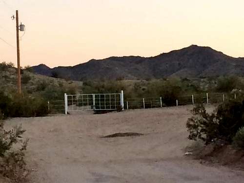
End of Bell Rd parking area with White Gate
For those that want to start at an official trailhead and take on more mileage, you from the Dynamite trailhead and follow the trail for a bit until starting the cross country from there.
Route
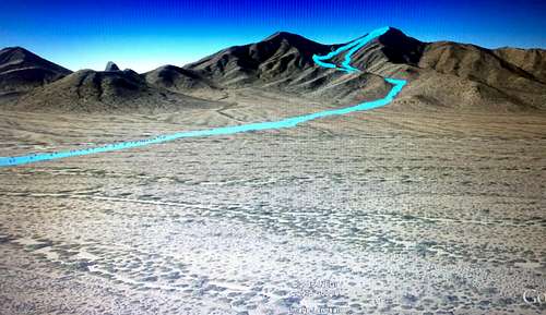
Screencap of Route from GPS Data
From the parking area at the very south end of Bell Road, you will have to go through or around the gate and then turn to your right (2 O'Clock) which will point you directly toward the summit. There are some dirt paths to follow for short amounts of time, but none will take you very direct so you can follow the path of least resistance while aiming for the peak. Depending on the route you take, you may encounter a few barbed wire fences. Eventually you will find your way to the drainage that heads up to the saddle south of the peak. After ascending the drainage for a while it starts to get steep. About halfway up, it is easier to take the drainage on your right before the peak to attain the ridge and then when you get the ridge, take it on your left up to the summit.
Alternatively, you can just follow the drainage all the way to the saddle, and then hang a right straight up to the summit, but this requires more scrambling among Cacti. It is a pretty gnarly, but fun scramble in places.
Red Tape
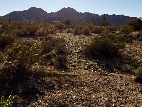
Some of the better conditions you'll encounter enroute to the summit (center)
llmcguir - Nov 10, 2020 8:54 am - Hasn't voted
No parking on Bell RdI posted this in the "Ascent Log", but just to reiterate: I wouldn't try parking on Bell Rd because there is now a housing community being built BEYOND the white fence, and there are lots of "Private Property" & "No Trespassing" Signs posted both before and after the white gate. Also, I heard a lot of shooting/target practice going on somewhere in the desert. Back at my car on Bell Rd., a vehicle stopped me and said I need to be careful back in that desert because people shoot guns freely as it is private property. If you want this peak, park at the Goldmine TH, however be aware that that people might be shooting for target practice out there closer to the base of the high point peak.
CCofQC - May 17, 2021 6:47 pm - Hasn't voted
No Trespassing - Both private and Gila River Indian Reservation (actual mountain)This entire route is on private land including the Gila River Indian Reservation. It is a shame some feel entitled to willingly trespass on well marked gated and fenced private land with No Trespassing signs. The track should be removed by the admins as well as any instructions on how to access the mountain. If you want to hike the mountain ask for permission from the Gila River Indian Community. They are unlikely to give it. It is their land and you should respect it. As someone else mentioned other entitled people cut fencing and go shooting on this land. You could easily be shot and killed and no one would know it. Law enforcement will respond to trespassers and those who own the private land are actively watching for violators. If you are dumb enough to cut fencing you are allowing cattle and horses to escape. Both of which have been killed because of your negligence. Enjoy the view from the park and stay off of private land. It's a great mountain. Sorry that it isn't legally accessible.