
-
 11834 Hits
-
 75.81% Score
-
 6 Votes
|
|
Route |
|---|---|
|
|
32.34530°N / 111.1503°W |
|
|
Hiking, Scrambling |
|
|
Spring, Fall, Winter |
|
|
Half a day |
|
|
Class 3 |
|
|
Overview
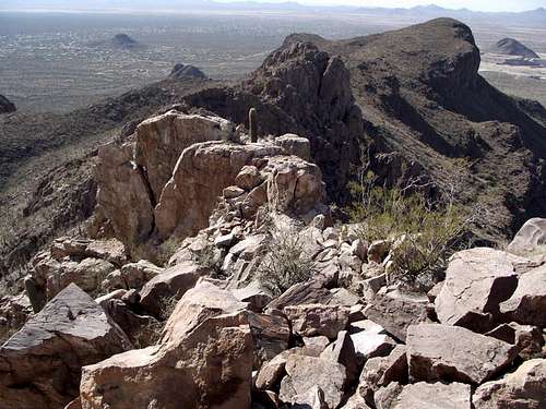 Looking west down the most narrow part of the summit ridge
This out-and-back desert outing features a trail or footpath all the way to the summit. However, the trails are often a confusing maze and a bit of easy scrambling is required near the summit with a touch of exposure. The route-finding to the summit is relatively straightforward to experienced route-finders with a keen eye, but based comments in the summit register, a number of people get stuck on the summit unable to find their way down. Those unfamiliar with this route should travel with a partner and make careful note of landmarks (and even, perhaps, GSP coordinates) to ensure a timely return. This route rewards those with good old-fashioned, micro route finding skills
The variety of desert flora along this route is superb and the views of the Tucson metropolitan area, as well as the numerous mountain ranges beyond, are excellent. This route can be dreadfully sun-beaten and hot, so avoid this route in the mid-day or in the summer months. The footpath proper rates Class 1 – Class 2 in rougher spots, while steep-ish, four-paws scrambling, and a neat move or two over a little “sidewalk in the sky”, are required to reach the summit.
Distance: Roughly 3.5 miles roundtrip
Elevation Gain: 1,200 feet
YDS Rating: Class 3 (with mild exposure)
Getting There
 Route Map with Key Waypoints
 Sanctuary Cove Route Map
• From I-10, take Exit 246 (Cortaro Road)
• Take Cortaro Road west.
• Turn north on Silverbell Road
• Follow Silverbell until you reach Coachline Road.
• Turn left (west) on Coachline, which is also known as Continental Reserve Loop Road
• Turn right onto Pima Farms Road
• Follow Pima Farms Road to a t-intersection with Scenic Drive (at the entrance to the Lazy K Guest Ranch)
• Turn left (south) at the T At Scenic and Pima Farms and continue ¼ mile down the dirt road.
• Sanctuary Cove is on the right (west) side of Scenic Drive
• The parking area is noted by several use-instruction signs
Route Description
| Mostly solid rock to summit | Last easy summit scramble | Typical upper route conditions |
 |
 |
 |
 Approaching from the NE
 Unmaintained trail from saddle
 Leaving the lower saddle for the peak
 Loose rubble toward upper saddle
 A few big steps are required to make the summit
 Final few steps to summit
• The peak is visible from the parking area. Leave the parking area and head toward cinderblock church.
• There is a wild maze of paths back here. Trend west-northwest initially.
• Follow the primary path westward toward the ridge. The trail loops around southward.
• You may notice an inspirational sign, perhaps about happiness. Shortly after this is a critical right-hand turn up a rocky, less-maintained path.
• After ascending the loose trail westward, you will gain a ledge that allows for smoother travel. Continue southward on the path, crossing the fence line that marks the property boundary, traversing toward the low saddle east-northeast of Safford Peak.
• From the saddle, follow a footpath westward directly toward Safford Peak.
• The path will again trend southward, heading directly toward the cliffs encircling Safford Peak.
• Follow the faint path heading first south then southwest around the base of the cliffs. Do not be fooled into heading up the first gully encountered on the south cliffs of the peak – this will simply take you to an overlook.
• Follow the trail around the base of the cliff-band to the bottom of a broad gully. This is your ascent route.
• Turn north up this gully toward the upper saddle. The path is braided in parts here and the rock is loose, so take the route that looks & feels most stable to you.
• From the upper saddle, the route becomes more interesting. Turn east (to your right) and ascend the rocky sub-summit.
o In many places, the remaining ascent requires 4-paws class 3 scrambling and those unfamiliar with fall exposure may find a few places unsettling.
• Beyond this sub-summit, you will encounter a very short ‘sidewalk in the sky.’ Cross this sidewalk, being mindful of the smooth-ish slab you will encounter, and continue scrambling to the top of the peak. The summit is marked by a large summit cairn and includes an ammo box for summit register.
| Looking down loose rubble | Easy scrambling | Past the little sky sidewalk |
 |
 |
 |
Essential Gear
 Narrow section of trail hugging cliff
In addition to standard hiking gear appropriate to the season, the following are recommended when summitting peaks in the Tucson Mountain Range:
• Climbing gloves (leather or suede are more durable, but simple cotton gardening gloves work, too)
• A lot of water (more than you think you’ll need). There are no water sources at the trailhead or along the route.
• Sun-protective clothing, particularly long-sleeves and a brimmed hat, and sunscreen.
• Salty snacks.