
-
 50598 Hits
-
 91.45% Score
-
 35 Votes
|
|
Route |
|---|---|
|
|
35.21180°N / 106.4494°W |
|
|
Hiking |
|
|
Spring, Summer, Fall, Winter |
|
|
One to two days |
|
|
Class 1 |
|
|
Overview
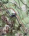
The Sandia Crest Trail traverses the entire range of the Sandia Mountains and can be hiked in either direction. The northern end of the trail is located at the Tunnel Springs Trailhead while the southern end is located at the Canyon Estates Trailhead. Although there is a "main" trail, there are many variations to this trail that can shorten or lengthen the trip, as well as, many possible side trips. Most people will take two days to complete this trek, some people will make the journey in one very long day. There are other options to just hike portions of the Crest. If hiking this trail in late fall, winter, or early spring be ready for significant amounts of snow and/or ice.
A unique aspect of this trail is that you can stop in the Crest House and battle the throngs of tourists or stop in for a beer and a burger at the High Finance Restaurant at the top of the tram. Other than the section between the Crest House and top of the Tram it's likely you'll see very few people.
Logistics
Since this is a one-way journey you'll need to set up a car shuttle or have someone drop you off and pick you up. The trail can be hiked in either direction with both having benefits. Most people tend to hike from north to south. While the trailheads are usually safe leaving a car overnight should be done at your own risk.
Directions to Tunnel Springs: From the center of Albuquerque travel north on I-25 to exit 242 (Placitas/Hwy 550/Rt 165). From the exit turn right (east) and continue on Rt 165 for about 5 miles. Turn left onto Tunnel Springs Rd. Continue about 1.5 miles until the road ends at the parking area/trailhead.
Directions to Canyon Estates: From the center of Albuquerque travel east on I-40. Take exit 175 and stay right at the fork. From the off ramp get in the left lane, turn left, and go under the I-40 bridge. It will immediately come to a "T". Going left will take you back to the highway so go right onto Arrowhead Trail. When the road splits go left, staying on Arrowhead Trail. Continue on this road until is ends at the paved circular trailhead.
Route Description
Since the Sandia Crest Trail is so long I have broken it down into segments so it is more manageable. In addition, a few alternate routes and side trips have been included. There are many other alternate routes, combinations of trails, and side trips not listed on this page. If you are looking to hike the Crest Trail and only the Crest Trail this page should be very helpful. If you are looking to explore the Sandia Mountains this page should help but also check out some of the other Sandia Mountain pages here on SummitPost.
| Segment Start | Latitude | Longitude | Segment End | Latitude | Longitude | Route | Distance | Net Gain/Loss |
|---|---|---|---|---|---|---|---|---|
| Tunnel Springs | 35.291°N | 106.440°W | 10K Trail | 35.238°N | 106.450°W | Crest Trail | 8.4 miles | 3600ft gain |
| Del Orno Route | 6.0 miles | 3600ft gain | ||||||
| 10K Trail | 35.238°N | 106.450°W | Crest House | 35.211°N | 106.449°W | Crest Trail | 2.0 miles | 650ft gain |
| Crest House | 35.211°N | 106.449°W | Tram Terminal | 35.196°N | 106.434°W | Crest Trail | 1.5 miles | 400ft loss |
| Tram Terminal | 35.196°N | 106.434°W | Tree Springs Trail | 35.188°N | 106.420°W | Crest Trail | 1.6 miles | 700ft loss |
| Tree Springs Trail | 35.188°N | 106.420°W | Pino/Cienega Trails | 35.169°N | 106.414°W | Crest Trail | 1.9 miles | 250ft loss |
| Pino/Cienega Trails | 35.169°N | 106.414°W | CCC Trail Intersection | 35.112°N | 106.427°W | Crest Trail | 4.7 miles | 150ft gain |
| CCC Trail Intersect | 35.112°N | 106.427°W | Canyon Estates | 35.090°N | 106.392°W | Crest Trail | 5.8 miles | 2800ft loss |
| CCC Trail | 4.0 miles | 2800 ft loss | ||||||
| Tunnel Springs | 35.291°N | 106.440°W | Canyon Estates | 35.090°N | 106.392°W | Crest Trail | 26.0 miles | 100ft gain |
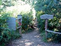
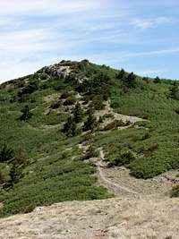
Tunnel Springs to 10K Trail
Click to enlarge
The first segment of trail climbs a majority of the elevation to the Crest along a meandering trail on the north side of the mountain. The hike can get steep in places but the trail is well maintained. Tree cover will provide shade during most of this segment.
Alternate Route: The Del Orno Route is a steep loose trail that can cut off considerable distance by climbing up a dry wash. Trekking poles are highly recommended if you take this route because the trail is so loose and steep.
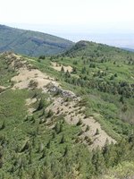
10K Trail to Crest House
Click to enlarge
A fun mellow section of trail. At this point there is not much elevation gain left before reaching the summit. The trail is wide and easy to follow and often comes close to the edge of the Crest offering wonderful views. There are many places to step off the trail onto solid limestone at the edge of the cliffs to view the city and other mountains below. Some of the best views of the Needle are found along this section of trail. Near the summit you will pass by the plethora of radio towers at the top of the peak next to the Crest House.
Side Trips: North Sandia Peak (add 0.7 miles round-trip, 250ft gain)
A quick side trip to an unranked peak offers similar views at the edge of the limestone cliffs. At the very summit you can find a foundation from an old radio tower that is long gone.
 |
 |
 |
 |
| Crest from Needle overlook | Crest House Area | N Sandia & Needle | N Sandia & Shield |
|---|
Crest House to Tram Terminal
Click to enlarge
While this section of trail is by far the busiest it does offer astounding views of the surrounding mountains. The Crest house is full of souvenirsand has a small grill and snack shop. The Tram Terminal has a restaurant and bar. Bathrooms can also be located in both areas.
Alternate Route: Hiking directly along the top of the Crest to Kiwanis Meadow and the CCC Cabin will provide much better views of the rock spires below than the standard Crest Trail. From the cabin head SE to regain the Crest trail to the Tram Terminal. This route is the same distance as the Crest Trail
Side Trips: The CCC Cabin can be accessed along the way or is only a few hundred feet from the Crest Trail below the Kiwanis Meadow. The CCC cabin was built in 1936 by the Civilian Conservation Corps. This stone cabin sits atop the limestone cliffs and is a worthwhile side trip.
|
 |
 |
| Crest House Area | Upper Tram terminal | CCC Cabin |
|---|
Tram Terminal to Tree Springs Trail

Click to enlarge
Once past the Tram Terminal it is unlikely you will see many people. The trail continues downhill and switchbacks a few times. The trail will lead you away from the limestone cliffs at the edge of the Crest into thicker forest. It is a nice change of scenery and offers some shade from the sun.
|
 |
| Upper Tram terminal | Tree Springs/Crest intersect |
|---|
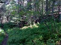
Tree Springs Trail to Pino/Cienega Trails

Click to enlarge
This section of trail has many small ups and downs which is a change from the steady downhill from the Crest House. The entire section is thickly forested and well shaded. It can be hard to tell that you are at the top of the Crest.
 |
 |
| Pino Trail intersection | Cienega intersection |
|---|
|
 |
 |
 |
| Tree Springs/Crest intersect | Crest Trail near Point 9627 | Point 9627 from Point 9579 | Point 9627 and Point 9579 |
|---|
Side Trips: Point 9627 (add 0.5 miles round-trip, 250ft gain)
For peakbaggers there is a ranked peak not far off the Crest Trail. A short bushwhack will bring you to the top of Point 9627. The summit is surrounded by trees which block most views.
Pino/Cienega Trails to CCC Trail Intersection

Click to enlarge
This segment begins by climbing up from the Point 9627/Point 9579 saddle. It continues through the thick forest before leveling off below South Sandia Peak. In this area below the peak there are large meadows bordered with large stands of trees. During this segment you will also run across a well built lean-to that has been around since at least the 1970s. This would provide a nice roof over your head if you decide to stay overnight.
Side Trips: Point 9579 (add 0.2 miles round-trip, 100ft gain)
For peakbaggers there is a ranked peak not far off the Crest Trail. A short bushwhack will bring you to the top of Point 9579. Unlike Point 9627 this summit is mostly open and provides some wonderful and seldom seen views of the Sandias and surrounding mountains.
 |
 |
 |
| South Sandia Peak | Pt 9579, S Sandia from 9627 | S Sandia & middle Crest Trail |
|---|---|---|
 |
 |
|
| Lean-to shelter | S Sandia turn-off | Point 9627 and Point 9579 |
CCC Trail Intersection to Canyon Estates

Click to enlarge
After leaving the open meadows near South Sandia Peak you will begin to slowly descend. After a while the trail will turn away from the edge of the Crest and begin to switchback down the hill. The slope gets steeper and the temperature will rise. In the summer time it can get quite hot on this section of trail so be sure you have plenty of water left. Once you get lower there will be a number of intersections with the Faulty and other trails. Staying on the correct trail is not too difficult, just remember to keep heading downhill.
Alternate Route: The CCC Trail can cut some distance off this segment but it is steep and not maintained as well as the Crest Trail.
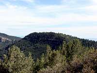
Side Trips: South Sandia Peak (add 1.7 miles round-trip, 400ft gain)
By following the Embudito trail down to a short distance you can intersect the short trail that leads up to the summit of South Sandia Peak. The second tallest distinct point on the Crest, South Sandia Peak offers incredible views of the Sandias. Any trip to the summit requires a long hike so this summit does not see much traffic.
 |
 |
 |
| S Sandia's summit | S Sandia's summit | Crest trail - S Sandia |
|---|
Essential Gear
Typical gear for a multi-day hike. Be aware that although it may be warm at the bottom it will get cold at the top. In late fall, winter, or early spring expect snow and bring snowshoes.
Camping
There are no established campgrounds in the Sandia Mountains. Camping in Cibola National Forest and the Sandia Mountain Wilderness is allowed however, fires are prohibited. The lean-to shelter between the Pino/Cienega and CCC trail intersection is an excellent camping spot.
External Links
Information about the Sandia Peak tramway, ski area, and the High Finance restaurant on the top of the Sandia Crest: Sandia Peak
Local weather: Albuquerque
Local Search and Resuce Team: Cibola SAR
Cibola National Forest - Sandia Ranger District
Sandia Mountain Wilderness
Hiking in the Sandia Mountains
Friends of the Sandia Mountains