
|
|
Area/Range |
|---|---|
|
|
33.52236°N / 117.25991°W |
|
|
Hiking |
|
|
Spring, Summer, Fall, Winter |
|
|
2050 ft / 625 m |
|
|
Overview
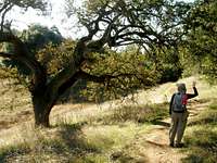
The Santa Rosa Plateau Ecological Reserve is a special place in Southern California. Ancient oak woodlands, rolling grassland of bunchgrasses, cool riparian areas, rare vernal pools, plentiful wildlife including many sensitive species, gorgeous views, old adobes, mortar holes in the granite rocks, and lots of hiking trails... I am so glad the Nature Conservancy and others had the foresight to protect this area from development. As a native Californian I know how rare it is to see these lower elevation areas that haven't been used and abused in some way... and now since it's been preserved everyone has access to its treasures!Santa Rosa Plateau Ecological Reserve is located at the southern end of the Santa Ana Mountains in southwest Riverside County, near the city of Murrieta. The Reserve is currently managed as a Riverside County Park.
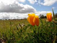
The Reserve consists of 8,300 acres and protects more than 200 species of native birds and 49 endangered, threatened or rare animal and plant species. In the springtime, typically March and April, the wildflower bloom is spectacular. Chocolate lilies are among the sought-after species by reserve visitors.
Some animal species protected on the Reserve include mule deer, mountain lion, badger, bobcat, western pond turtle, California newts, white-tailed kites and fairy shrimp. There are two species of fairy shrimp that live in the vernal pools on the reserve and no where else on Earth.
A plateau is a large, elevated landmass that is fairly flat in relief. The Santa Rosa Plateau is approximately 20,000 acres in size, and is bounded by Los Alamos and San Mateo Canyons in the north, the Santa Margarita Mountains in the west, the Temecula/Murrieta Valley on the east, and Mesa de Burro in the south. The Santa Rosa Plateau Ecological Reserve manages approximately 8,000 acres of the Plateau.
The Plateau’s topography is dominated by six main mesas. A mesa is simply an elevated land mass that is smaller in size than a plateau. Colorado Mesa, Mesa de la Punta, and Mesa de Burro are the mesas within the Reserve, while Avenaloca Mesa, Redonda Mesa and Miller Mountain (Mesa) are found outside of its boundaries. Adjacent to, and separated by, a dip or saddle from, Mesa de Burro is a land form sometimes referred to as No Name Mesa. This is not often included in the total count of Plateau mesas because of its limited size. It may in fact be categorized as a butte (an elevated land form with a flat top and smaller than a mesa).
These mesas, or the processes that created them, are the chief reasons why the Santa Rosa Plateau exists. They are made of basalt that resulted from ancient lava flows. The basalt helps create the vernal pools. The clay soils eroded from the basalt retain enough moisture for bunchgrass prairie species. Bedrock outcrops of granite allow water to remain in tenajas along stream beds throughout summer for aquatic and terrestrial species alike.
Visitors to the Reserve can also enjoy the oldest standing structures in Riverside County that once served as bunkhouses for cowboys dating back to 1846. These two adobe structures remain shaded by a 400 year old tree and separated by a relaxing, one-of-a-kind, picnic area.
Getting There
From I-15 in Murrieta take the Clinton Keith Road exit and head west about 4 miles. You can park near the Visitor Center, 39400 Clinton Keith Road. Or go a little further to the Hidden Valley or Vernal Pool Trailheads to park. There are several day's worth of trails here, I recommend picking up a free map at the visitor center. Visitor Center hours are 9 a.m. - 5 p.m. daily.
Red Tape
Entrance fees are: $2/person, $1/children aged 2-12.
The Reserve is occasionally closed after heavy rain.
Leashed dogs, horses, and mountain bikes are only allowed to the north side of Clinton Keith Road in the Sylvan Meadows multi-use area. The fee for dogs and horses is $1/each.
Camping, campfires, and smoking is not allowed.
Hunting is not allowed. Firearms are prohibited.
Please stay on marked trails.
All natural and cultural features are protected.
Please follow Leave No Trace ethics.
External Links

Santa Rosa Plateau Ecological Reserve
Reserve history
Reserve geology
Santa Rosa Plateau Foundation
Field Guide to the Santa Rosa Plateau
Weather for Murrieta, CA
Link to my two Santa Rosa Trip Reports - January 2009 and March 2010