
|
|
Route |
|---|---|
|
|
43.58039°N / 122.75698°W |
|
|
Spring, Summer, Fall |
|
|
Overview

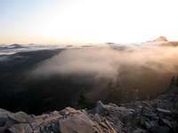
Cowhorn and sunrise from Sawtooth mountain
Originally called Little Cowhorn Mountain, while Mt. Thielsen to the south was called Big Cowhorn Mountain. It now suffers from a identity crisis of sorts. It's horn-shaped summit spire fell off in a 1911 storm, and the name was changed to just Cowhorn. Know it is the least widely recognized of the High Cascades' major peaks.
Cowhorn Mountain is a highly eroded Central Cascades volcano just North of Crescent Lake in the Oregon Cascades Recreation Area (OCRA.) Established in 1984, the OCRA contains 156,900 acres of land managed by the Forest Service. The OCRA is flanked on the north by the Diamond Peak Wilderness and on the south by the Mount Thielsen Wilderness, and offers visitors a range of scrambling, hiking, and climbing opportunities.
Great ridge leading to summit of Sawtooth. Cowhorn in background
I've included this scenic 15.5 mile loop route from Timpanogas Lake instead of the shorter route from Windigo Pass. This is partly because the Windigo Pass route is already on SummitPost and because it's vastly superior compared to the other hike. This also includes a side-trip up the equally impressive Sawtooth Mountain. This loop description heads in a counter clockwise fashion.
Starting from Timpanogas Lake hike 1.9 miles to Indigo lake. This is one of the finer backcountry lakes in this area. (I recommend the 1 mile hike around the lake. It has the best views of the Indigo color of the lake and the scree field below Sawtooth is loaded with the rarely seen Pika.) The actual trail to Sawtooth and Cowhorn is 200 ft before the lake. Take this 1.7 miles to Windy Pass. To get to Sawtooth cross the ridge and head downhill and then to the south 1.4 miles until the trail peters out at the scree field on the east side of Sawtooth. Scramble .4 miles to the summit. There are some sweet variations to do some class 3, maybe 4 scrambling up to the north ridge. These are just to the north of the basic scramble. Rock cam be loose here so be careful.
Retrace route back to Windy Ridge and follow the trail 2.1 miles to the trail jct. on the right. This takes you towards Cowhorn and the PCT. After .2 miles turn right onto the PCT. Head .3 miles and just before dropping downhill there is a rock cairn. Turn left and head up the climbers trail. Walk until you are out of treeline. Then head up the loose volcanic scree to the false summit and over the hogsback to the base of the class 2 scramble to the summit. Enjoy views from the Three Sisters to the north and Mt. Mcloughlin to the south.
Retrace route back to Windy pass trail. Follow it 2.7 miles to next jct. Turn left and walk 1.1 miles back to Timpanogas Lake. Then .4 miles around lake back to the parking lot.

Timpanogas lake in foreground, Summit lake in background from Sawtooth
Getting There
While the shortest but least scenic route is the Windigo Pass trail. This has already been covered on Summitpost and I believe this route from Timpanogas is vastly more scenic.There are multiple ways to reach Cowhorn. To reach it from the West take Willamette Highway 58 1.8 miles west of Oakridge to "Hills Creek Dam" between mileposts 37 and 38. After half a mile bear right onto Road 21 and follow this paved route 31.2 miles. Three miles beyond Indigo Springs Campground turn left onto Timpanogas Road 2154. Then follow signs for Timpanogas Lake 9.3 miles to Timpanogas Campground, where a hiker-symbol sign points to the TH parking area on the right.
To reach from the East take Willamette Highway 58 to Crescent Lake and drive southwest on FR 60 about 5 miles. Then from Summit Lake head south towards Timpanogas Lake and Campground on Timpanogas road 2154.

Hippy on Sawtooth
Red Tape
Northwest Forest Pass required.
Hippy on a stick