
|
|
Route |
|---|---|
|
|
44.11846°N / 73.82572°W |
|
|
Hiking |
|
|
Spring, Summer, Fall, Winter |
|
|
Half a day |
|
|
class 2 |
|
|
Overview
The Scenic Trail is the original path up, over the "sawteeth" to the summit of Sawteeth from the Lower Ausable Lake Dam. As the name suggests, it is very scenic with many overlooks peering down to Lower Ausable Lake and over to many surrounding peaks from the cliffsides above.The Lower Ausable Lake area and the trails leading to it are very beautiful. These areas are on the property of the Adirondack Mountain Reserve/Ausable club lands. Following the regulations of this area is important because without the permission of the AMR/AC, none of these beautiful areas would be accesable. For red tape info on this area please see the St. Huberts Parking Area/Trailhead page.Getting There
The Scenic Trail can be reached by using the St. Huberts Parking Area/Trailhead to the Lake Road Trail, the East River Trail, or my favorite, the West River Trail. All of these trails follow the East branch of the Ausable River to the Lower Ausable Lake Dam. Using this combination of trails, there is no shorter way to the summit of Sawteeth.The Trail
The west side of the Lower Ausable Lake Dam is where the West River Trail, the Alfred W. Weld trail, and the Scenic Trail merge. From this junction, follow signs for the Scenic Trail. For the first half mile, the trail follows the western shore of Lower Ausable Lake and then starts to climb the eastern side of Sawteeth.At mile 1, the first of six overlooks is reached, 250 feet above the lake. Overlook two is reached at mile 1.1.
After a steep section of trail, the third overlook is reached at 1.4 miles.
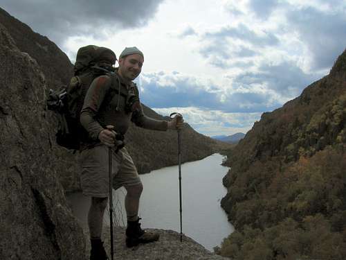 Taken from the third overlook
From Here, the trail markers are less frequent and the trail is slightly vague in some spots.
Next is the first of three ladders, after this ladder and some steep climbing is the fourth overlook, named lookout rock, 1300 feet above the lake at 1.8 miles.
At 2.1 miles a .3 mile signed spur leads to marble point with views worth the side trip.
Reaching a col at 2.2miles, the trail becomes very steep, climbing two ladders to reach the final overlook before the summit.
 One of the ladders.
This first col marks the State Land Boundary, you are now off of AMR/AC lands and Adirondack high peak Red Tape applies.
At 2.6 miles, a second col is reached named rifle notch.
At 3 miles an unnamed, but marked trail comes in from the left that leads down to the wardens camp. Continue right here and the summit is reached very shortly after. There are good views in all directions. Pyramid and Gothics loom above.
From the summit, a loop hike can be done by continuing down to the Sawteeth/Pyramid notch and descending back to the Lower Ausable Lake Dam via the Alfred W. Weld Trail.
Mileage & elevation gain
To Summit of Sawteeth (one way)From St Huberts Parking Area/Trailhead: 6.9 Mi. 2850 ft. gain
From Lower Ausable Lake Dam: 3.0 Mi. 2275 ft. gain
Recommended books/maps
A copy of High Peaks Region by the Adirondack Mountain Club is always a good decision.Red tape
Anyone staying overnight in the High Peaks area must fill out a self issuing trip permit available at all trail registers. One copy must be kept for rangers inspection at any time. Without this ticket a ranger can and will send you home.-Bear canisters are a requirement from april 1 to November 30 and you may be turned back by a ranger if you do not have one. for more info see the Adirondack Mountain Club website
Camping
-No camping above 4000 feet.-Any camping above 3500 feet at approved sites only. (currently Sno-Bird & Lake Arnold)
-No camping within 150 feet of any stream or water source.
-No soap or washing within 150 feet of water.
-Pack it in, Pack it out.
-Camping groups are limited to a party of 8
Some images from this trail
 Some shrooms along the Scenic Trail.
 View from the summit of Sawteeth. For the names of these peaks, click on the picture.
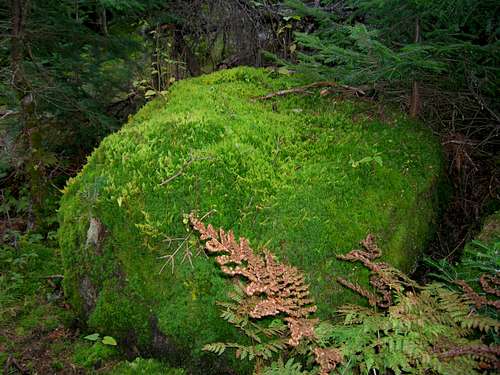 A mossy boulder & ferns.
 Pyramid (foreground) and Gothics behind it from Sawteeth
 Tremella Folicia growing on a fallen tree