
-
 6224 Hits
-
 71.06% Score
-
 1 Votes
|
|
Route |
|---|---|
|
|
46.72350°N / 10.48830°E |
|
|
Hike |
|
|
Half a day |
|
|
Walk-Up |
|
|
Approach
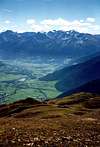
You'll get to Burgeis - the principal trailhead via SS38 ans SS40 from the south or S40 from Reschenpass in the north. In both cases just follow the Vinschgau / Val Venosta Valley.Route Description
Altitude gain: 1300mDuration: 4h
Difficulty: Hike
Trailhead: Burgeis
This is the most strenuous of the three routes towards Watles. You start out in the centre of Burgeis. Look for the trail, marked No 3, which heads out north. It heads steeply upwards along meadows and larch forests. After 45min at an elevation of 1600m the trail divides. No 3 heads towards Plantapatsch hut (if you follow this you can get to the summit via Pfaffensee (see the respective route).
Take trail no 4 which takes you two Alms, Kälberhütte and Schafhütte, the latter of which is already a ruin. From the ruin head towards Schafberg (2411m). You'll get onto its north western ridge. Traverse the summit and head along towards Watles in the southwest.
 |  |  |