
|
|
Route |
|---|---|
|
|
43.74840°N / 109.9567°W |
|
|
Mountaineering |
|
|
Summer |
|
|
Half a day |
|
|
Class 4 |
|
|
I |
|
|
Overview of Approach
See Main Page for travel directions to the Pinnacles Trailhead.The topo quad for the Pinnacles Trail is no longer accurate.
The area the Pinnacles Trail traverses has been reclaimed - trail is realigned slightly above the roads and stump zones.
Follow the trail for about 2 miles. Suffice to say
there is a slightly longer and steeper grade that then reaches a flatter area. From here, leave the trail, heading up the adjacent drainage.
 The SE Face seen from the slope above timberline at the top of the drainage. Seen from this angle, the route zigzags from the right edge to the left edge and back again, gaining through the cliff bands.
Climbing Route
The drainage below the SE face is probably best crossed before steeper ground is reached. Steep dirt slopes can then be ascended to the right to circumvent a few cliffy areas in the drainage; the goal is to reach the higher sloping plateau just below the ridge top. Once the slope is reached, traverse back to the left and work your way up to the summit face. This involves three 10'-20' cliff bands that go at Class 4 though somebody with good weather and lots of time might be able to lower it to Class 3. Zigzag up the ledges and intermittent bands. The final band pops you right within reach of the summit cairn.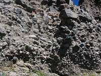 A close up of the main cliff band/step.
Anyone wanting more detail should find the recent guidebook listed on the main page.