
|
|
Route |
|---|---|
|
|
47.55874°N / 120.84726°W |
|
|
Hiking, Mountaineering, Scrambling |
|
|
Spring, Summer, Fall |
|
|
Most of a day |
|
|
Class 3 |
|
|
Overview
Cashmere mountain is typically done via the standard West Ridge route which takes the trail up past Little Eightmile Lake, up past the Caroline Lakes, and up the West Ridge to the summit. This makes for a long trek of 8-9 miles one way. This mileage total can be cut in half by taking a cross country route up the SE slopes to the gully between the S and SE ridges. The majority of the route is cross country, but in open terrain, and the gully is a class 3 scramble on fairly solid rock. ** Be aware however that the majority of travel is off trail. There is some brief bushwhacking, potentially loose steep dirt for a couple thousand feet, and some side hilling and/or boulder hopping before the class 3 scramble section at the end. This is not a typical trail route up and you should have some experience with off trail travel and anticipate and prepare for some of these challenges ahead of time.** Having done a loop up the SE route and down the standard West Ridge, I'd go so far as to say that anyone wanting to summit Cashmere in summer / fall should strongly consider the SE route over the standard West Ridge. Less miles, more interesting terrain, better views, and better scrambling in my mind make this the most appealing route for a day trip.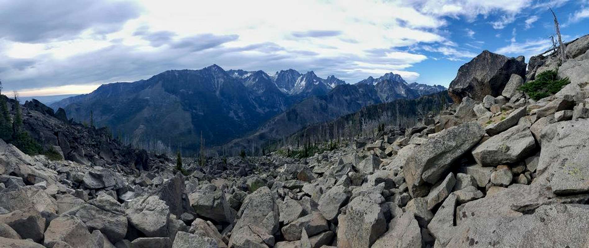
Enchantments from Cashmere SE Route
Getting There
From the town of Leavenworth on Highway 2, head south on Icicle Road 8.4 miles to Bridge Creek Campground. Turn left onto Forest Road 7600 and keep right at the fork onto Forest Road 7601 just before crossing the river. Continue another 2.8 miles to the Eightmile Lake trailhead.Route Description
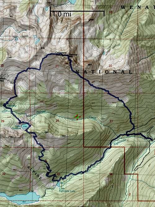
The route starts following the Eightmile Lake trail. Follow the trail for about 1/2 - 3/4 of a mile until you reach an old overgrown road. There are two connectors to this old road and I'd recommend taking the second one, but I'll describe both. The first connecting trail is about 1/2 mile from the trailhead. You'll see a fairly obvious very short (10 feet) trail on the right which leads to the old road. This part of the old road is a lower switchback and you'll need to turn left here where the old road will parallel the Eightmile Lake trail and meet up with the second connecting trail. You might as well stay on the Eightmile Lake trail for about 3/4 of a mile from the trailhead where you'll come across a large post with no sign. Turn right and follow the old road. The old road is getting pretty overgrown and there is a bit of bushwacking and a couple places where it's easier to head up the slopes on the side of the road to get around some of the brush. Follow this old road for maybe 10-15 minutes until you reach a significant washed out stream crossing. Cross the stream and continue on the road for a few more minutes before heading uphill to the left. The further you follow the old road before you start heading up, the more likely you are to find solid ground. There was a fire in the area in 1994 and some of the ground is very soft dirt / ash which is a pain to climb up. On my trip I started uphill shortly after the stream crossing and had to deal with about 1000 ft of this steep soft dirt which was the worst part of the trip. Continuing on the old road past the stream for a few hundred yards will likely provide better terrain as you start the cross country portion. I've marked the potential better terrain here in red on this google earth overlay which shows the SE route / West Ridge loop that I took.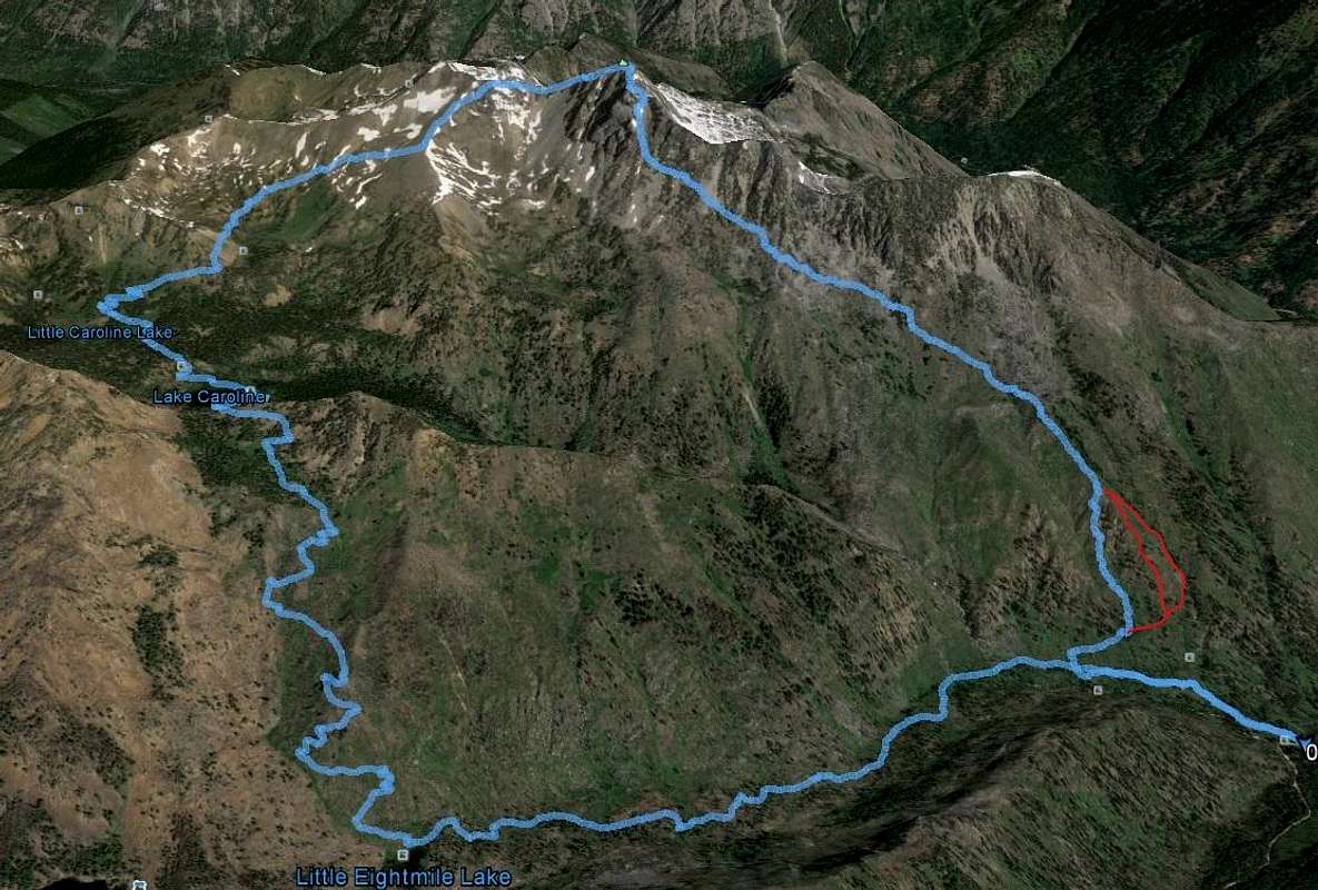
Cashmere Mountain SE Route / W Ridge Loop
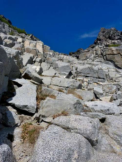
Regardless of when you start uphill, the idea is to make a rising traverse upward and left as you ascend towards the S / SE gully. The initial 1000 feet are the worst part of the trip. Make your way up to a bench seen on the topo map at ~5600 ft. Here the terrain starts to transition from dirt and foliage to boulders. Here you have a decision to make. Some people like boulder fields, some people hate them. If you dislike boulder hopping, stay low and left when you reach the bench at 5600 ft and avoid ascending too quickly. Some of these boulders are humongous. If you are the type that enjoys boulder fields, as I am, have at it! Maintain your ascending left traverse through the rocky, bouldery terrain and start looking for the Cashmere Dagger and the SE buttress which marks the start of the S / SE gully which you will use to reach the summit.
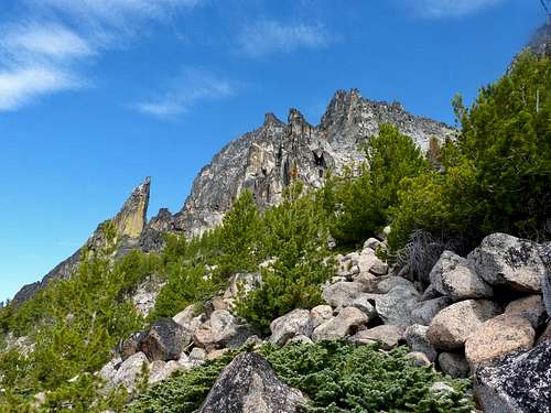 Cashmere Dagger and SE Buttress | 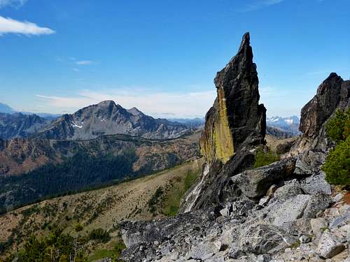 Cashmere Dagger and Eightmile Mountain |
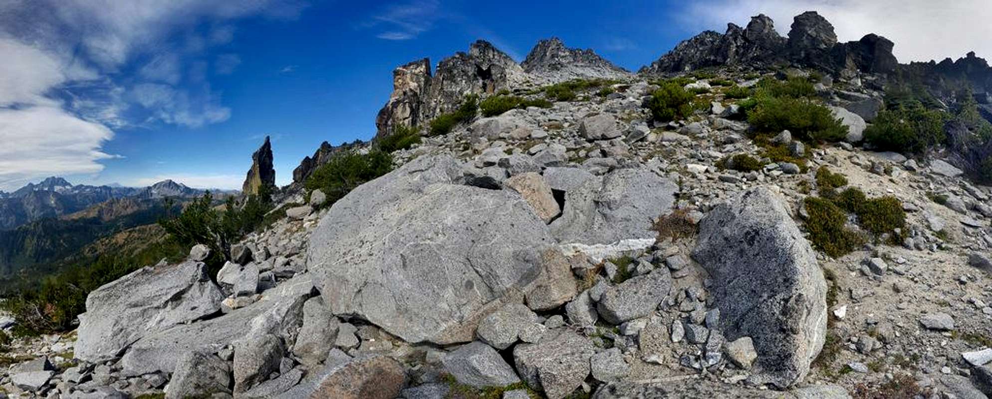
Cashmere S / SE gully (widest 'V' right of center)

Cashmere S / SE Gully Options (blue is class 3 on solid rock, green is class 2)
The S / SE gully is a wide broad gully with lots of options. It’s basically choose your own adventure. You can go straight up the middle for mostly class 2 if you want and there is solid class 3 and 4 rock on the climbers left side of the gully which is quite enjoyable if you’d prefer that. Pick your line up to the top of the gully at ~8150ft and start trending left (NW ish). Here the terrain gets the steepest, but with careful route finding it's a class 3 scramble on fairly solid rock from here on up. After a couple hundred feet of scrambling you'll reach a small saddle where you'll turn right and start heading north. Scramble up bypassing the summit block (which will be on your left) and make a mini corkscrew, turning left and reaching the true summit from the north.
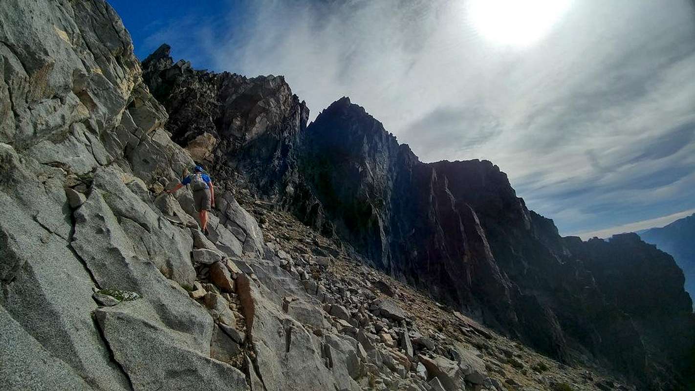
Ascending Cashmere SE Route
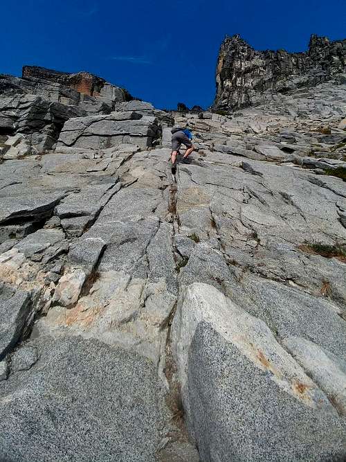 Scrambling Cashmere SE route (optional class 3+) | 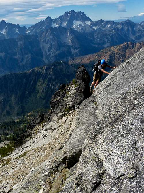 Traversing the Cashmere South Gully (optional class 4) |
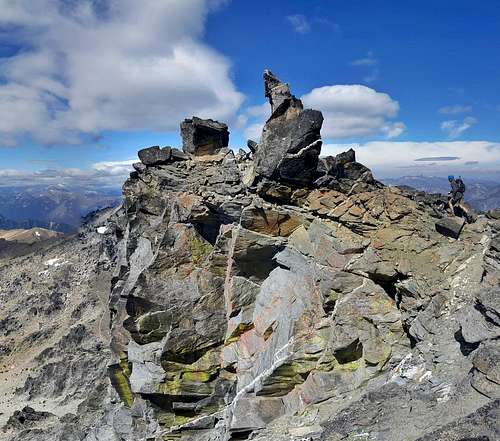
 Top of the S / SE Gully of Cashmere Mountain | 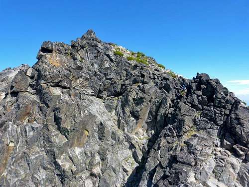 Cashmere Mountain Summit Block from the South (Jake on the right) |
I'm not 100% certain of the distance of this route but I'd guess it's about 4 miles one way. My calculations and measurements from my GPS track put it at about 3 miles one way, but I have a hard time believing that. I'll say 3-4 miles one way and 5200 feet elevation gain. Regardless, it's much shorter than the 8-9 miles via the standard West Ridge! Speaking of which, you can combine the two into a loop if you're so inclined although descending the west ridge without having gone up it first can be tricky but if you have a lot of scrambling and route finding experience you should be able to manage although I thought some of the moves on the West Ridge were harder than the SE route.
 Cashmere SE Route Topo | 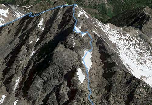 Cashmere Mountain S / SE Gully Route |
Descending Cashmere's West Ridge
helmet
GPS is not a bad idea since the majority of the route is cross country
External Links
My trip report here.Brushbuffalo trip report here.
Justus S. trip report here.