
-
 2400 Hits
-
 74.01% Score
-
 4 Votes
|
|
Route |
|---|---|
|
|
46.75983°N / 11.47505°E |
|
|
Hiking |
|
|
Summer, Fall |
|
|
Half a day |
|
|
Class 3 |
|
|
Hike and Scramble |
|
|
Overview
 Dornholzer See / Lago Valdurna Dornholzer See / Lago Valdurna |
As far as I can tell there are two routes to Jakobspitze / Cima San Giacomo, one which heads to Flaggerscharte and from there across Lorenzspitze / Cima San Lorenzo and the north ridge to the summit, the other through Tellerjoch (sidestep to Tellerjochspitze / Montello possible) and the west ridge. There might be a third route along the south ridge with Liffelspitze / Monte Livolo and Foltschenoispitze /Punta Valcenai as earlier stages. Of these routes the Tellerjoch Route certainly is the least difficult though the final summit ridge shows some exposure and difficulties.
Interestingly, this route to Jakobspitze / Cima San Giacomo is far less popular than the normal route along the north ridge, most likely caused by the fact that you won't be able to find it on any map. However, it is marked and in considerably good shape so that a combination of both routes is clearly possible, especially as they share the lower half.
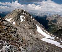
The first half of the route is little more than a hike along a well trodden path in the direction of Flaggerscharte. From there to Tellerjoch you traverse the rocky north face of Jakobspitze / Cima San Giacomo, where you can find snow up to quite late in the year. Above Tellerjoch the route turns into a rocky ridge traverse.
Getting There
The trailhead is Durnholz / Valdurna. The main page details, how to reach it by car.Route Description
 The upper part of Seebbachtal / Val Sebia
- Start altitude: 1510m
- Summit altitude: 2748m (2563m / Tellerjochspitze)
- Prevailing exposure: North, later North and South
- Type: Hike and Scramble
- Protection: none
From the parking lot at the end of the road before Durnholz / Valdurna follow the lake promenade on the north shore of Durnholzer See / Lago Valdurna. At its eastern end the road splits. Take the left branch which heads into Seebbachtal / Val Sebia, following the signs to Flaggerscharte and / or Hohe Scheibe. The dirt roads starts to ascend and slowly winds its way to Seebalm / Malga Sebia.
 |  |  |
Pass the pasture, still climbing in eastward direction. The trail narrows to a path which soon heads above the timberline. The path to Hohe Scheibe turns off to the left. Still remain on the Flaggerscharte route. After a wide mountain meadow the trail suddenly starts steeply upwards to negotiate a step in the terrain. On its top the Tellerjoch route turns off to the right. From this spot Flaggerscharte and the north ridge route to Jakobspitze / Cima San Giacomo are only 20 minutes away (still ascending further east).
Turn onto the path to Tellerjoch, which runs in south-westerly direction. The saddle can be clearly seen and the path more or less directly heads for it through the north face of Jakobspitze / Cima San Giacomo. At first it stays at the same elevation but the closer it gets to Tellerjoch, the steeper it gets. It avoids the saddle, instead climbing the slopes to its east, heading onto the Jakobspitze west ridge some 200m beyond the saddle.
 |  |
In case you want to climb Tellerjochspitze / Montello leave the path where it gets closest to Tellerjoch. Climb the remaining 50m to the saddle, from where a path-less scramble leads you to the main summit. For the summit cross you have to descend to the west summit, which can be done without any problem.
For Jakobspitze / Cima San Giacomo turn onto the ridge, which at first remains relatively broad. The path switches sides several times and there are several relatively steep sections, A first step is taken, after which the path levels, only to steepen for the ultimate summit section again. The rock stays brittle so that any approach to the steep north face is a bit precarious.