
|
|
Route |
|---|---|
|
|
36.32981°N / 50.93918°E |
|
|
Mountaineering |
|
|
Summer |
|
|
A few days |
|
|
Hike |
|
|
Getting There
Directions for Sehezar Valley:From the coastal town of Tonkabon (Shahsavar), you will have to drive roughly 50 Km up nameless remote roads through the forested slopes in the Sehezar Valley to reach the end of the road at the village of Shahrestan (elevation 2000 m)(sorry about the vague directions, we were driven by locals through these roads). Hiking starts here.
Route Description
All distances are per my GPSPlace………........Elevation m………Distance Km
Sahrestan
Village…………..2000………………Zero
Darjan
Village…………...2050………………0.75
Hot Springs………2550………………7.7
Garma Gardan
Saddle…………….3990………………11.3
Meeshchalak………4067………………1.1
Total…………………………………….20.85 Km
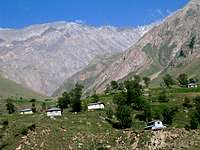
The village of Shahrestan sits to the east of the Sehezar River at an elevation of 2000 m It marks the end of the Caspian Forests (which come up the Sehezar Valley to an elevation of 2000 m). From Shahrestan, head south and hike a trail up the valley less than a Kilometer to reach another village named Darjan.
 Mian Rood
Above (to the south of) Darjan, the trail continues up the valley on the east side of the Sehezar River until it reaches a last settlement named Mian Rood (2150 m) which is nothing more than a few homes. Here the trail crosses to the west of the river and goes through a somewhat of a “narrows” until at an elevation of 2300 m a major branch splits off of the Sehezar River to the west of it. Here, you will have to cross back to the east side of the stream and stay there all the way to the top of the valley.
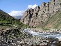 Near Narrows
Continuing the trail up the valley will take to around 2550 m where Warm Water Springs appear on the west side of the river (to reach the springs you will have to cross a scary little bridge).
Keep hiking up the valley until at around 3700 m you find yourself in a big alpine bowl at the end of the valley below the Garma Gardan (Meeshchalak) Saddle. The trail makes switchbacks and goes up the slopes to reach the Garma Gardan Saddle. From the saddle, you will turn west and follow the ridge-top past Point 4044 m to reach the summit of Meeshchalak.
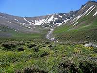 Garma Gardan Saddle