
-
 3395 Hits
-
 73.06% Score
-
 3 Votes
|
|
Route |
|---|---|
|
|
39.38480°N / 105.9262°W |
|
|
Hiking |
|
|
Spring, Summer, Fall |
|
|
Half a day |
|
|
Class 2 with route finding |
|
|
Overview
 Volz Benchmark from the saddle Volz Benchmark from the saddle14 June 2009 | This pleasant, off trail route takes the hiker up Selkirk Gulch over terrain where elk droppings outnumber boot prints. Following the Selkirk Gulch drainage, the hiker ascends to an unnamed saddled just below the summit of Volz Benchmark. Route finding over loose, somewhat steep, talus brings the hiker to the broad summit plateau where a summit cairn, rudimentary rock shelter and USGS marker, complete with summit register jar, await. Distance: 3.5 miles RT Elevation Gain: 1,600 ft. | 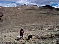 Lumpy UN 12,700 across the saddle Lumpy UN 12,700 across the saddle14 June 2009 |
Getting There
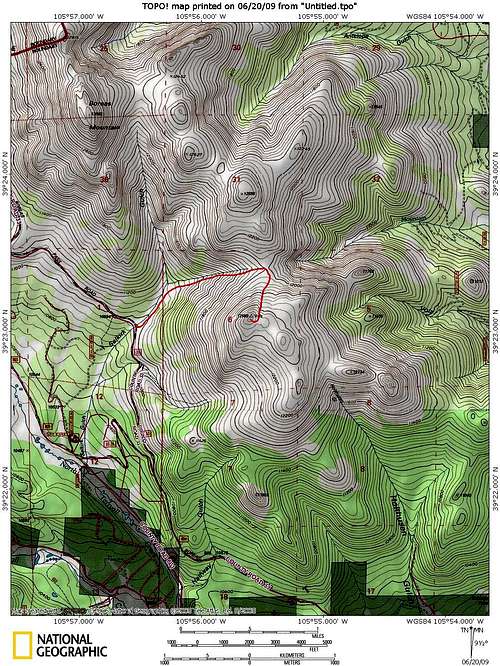
From U.S. Hwy 285 and Rd 33 at Como- Take Park County Rd 33 northwest through Como.
- At Robert’s Cabin, take a hairpin turn to the right to stay on Route 33 (Boreas Pass Road -- see brown Forest Service sign to Boreas Pass).
- Keep an eye out for “Rocky Point”, a point of interest on your left.
- Two miles past Rocky Point the road will pass over the creek draining from Selkirk Gulch.
- A small pullout that holds several vehicles will be available on the west side of the road.
- Your summit objective will be visible almost due east from the parking area.
From CO Hwy 9 south of Breckenridge
- South of Breckenridge, locate Boreas Pass Road (Summit County Hwy 10).
- Follow this road south for about 6 miles to the summit of the pass.
- Continue about 2.7 mile south of Boreas Pass where the road passes over the creek draining from Selkirk Gulch.
- A small pullout that holds several vehicles will be available on the west side of the road.
- Your summit objective will be visible almost due east from the parking area.
 Volz Benchmark from parking
14 June 2009
Route Description
From the parking area, the top of Volz Benchmark can be seen to your almost due east.- Carefully cross Boreas Pass Road and ascend a steep embankment on the east side of the road.
- A very faint old road will carry you into Selkirk Gulch.
- Follow the stream up Selkirk Gulch for about 1.5 mile to a broad, open saddle.
- Nearing the saddle, the summit of Volz Benchmark will loom above you to your south (right).
- From near the top of the saddle, turn southwest toward the summit of Volz Benchmark.
- A faint social trail might be discernable at this point to the observant hiker.
- Select your own route up the loose talus; the best route may vary depending on snow pack.
- Enjoy the views from the broad summit area.
 Click on image to enlarge
Essential Gear
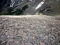 More loose talus More loose talus14 June 2009 |
| 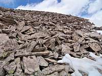 Loose Talus on Volz Benchmark Loose Talus on Volz Benchmark14 June 2009 |