
-
 3824 Hits
-
 72.08% Score
-
 2 Votes
|
|
Route |
|---|---|
|
|
42.85450°N / 0.7276°W |
|
|
scramble |
|
|
Half a day |
|
|
Walk-up |
|
|
Approach
Trailhead: Selva de Oza, near the camping and bar.For approach to Selva de Oza see the page of Castillo de Acher
Route Description
 Chipeta
 Sayestico
Slope: 960meters.
Time to summit: 2h 40min.
Before the bridge turn to the left side (indicated in the signal). In the other side of bridge of the road is the start of the route to Castillo de Acher that can be contemplated very nicely over the trees. After leaving behind the vision of the castle we enter a path easy to continue across the forest.
Very soon we come to a crossing path and we will continue towards the right indicated with cairns of stones. Little by little we are gaining height for the forest that becomes slightly more straightened up to going out to an area cleared near a nice waterfall. In this calm place we enjoy a creek and an excellent view of the great wall of the final of the range of Alanos with the peak of the Rincón de Alano (1600 meters, point of bifurcation to route of Lenito, Peña Forca and rincón de Alano in left side, cairns in the other side of the river).
Importantly: it will be seen when we come here the metallic signs that they us warn of the risk of avalanches in winter and spring beginning. It is necessary to have a lot of care with the condition of the snow in these epochs.
To reach the Col of Estribiella between Rincón de Alano and Estribiella we will ascend for one slightly hanging, easy channel in summer, though it will make us sweat for the hard slope. In winter it can need the use of suitable material (crampons and ice-axe) and is a little dangerous.
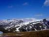
From the col we will reach with facility the nearby summit of Estriviella (2048m) and will enjoy the view of the landscape of Echo's valley to our feet. Now we spy perfectly the summit of Chipeta Alto to the north, that we can reach for the left(for the peak Tortiellas (1909m) or Chipeta Bajo (1897m)) or for right near of the edge of the ridge across the Punta Tortiellas (2079m). The summit of Chipeta Alto is a bit exposed and it is necessary don't forget the great fall that exists towards the Selva de Oza.
Generally the return is for the same route.
 |  |  |  |
Essential Gear
Nothing special in summer (except water).In winter crampons and ice-axe for the access to col of Estriviella.