
|
|
Route |
|---|---|
|
|
46.46740°N / 13.16230°E |
|
|
Hiking, Scrambling, Via Ferrata |
|
|
Spring, Summer, Fall |
|
|
Most of a day |
|
|
easy scrambling UIAA I/II- rather difficult via ferrata ( AD/D ) |
|
|
Overview
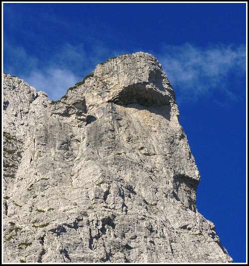 Cima della Sfinge
This route is one of the most spectacular of the southern carnic alps, but is rarely climbed because everybody knows how hard it is and how dangerous the ravines can be. But if you are not afraid of an elevation gain of more then 2000 meters and you like wild places, dark and deep gullies, dolomitic towers and gendarmi this long route will really satisfy you.
 south face
 west face
It is basically a clockwise ring around the mountain with two partly secured sections and with several ravines to climb going up and down until the notch called "il Portonat" ( the dark front door ) from where you can follow the normal route to the summit of the mountain. The "sentiero attrezzato A.Ferrucci" ( dedicated to the first alpinist that climbed this summit, on june 20, 1893 ) is a beautiful path that goes from Rifugio Grauzaria to Bivacco Feruglio following an exciting track trough amazing dolomitic towers. The via ferrata "Cengle dal Bec" ( the ledge of the billy-goat ) can be rated medium-hard and is mostly a long descent to the bottom of a dark gully, where the hard ascent to "il portonat" starts. The iron ropes are quite new and in good condition.
 La Medace
Although the average technical difficulties are not high this route can be advised only to expert and well fit people with alpinistic knowledge, because the frequent landslides can erase the paths on the ravines or damage the secured parts so you have to be prepared to find your own way and to climb not secured sections. Avoid the hot summer days of july and august, the final ascent to the Portonat and then to the summit can be really an hell!
Time required: 9/10 hours
Getting There
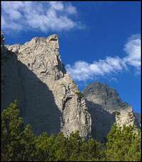
 seen from Val Aupa
From the road "Pontebbana" ( Udine-Tarvisio ) go towards Moggio Udinese - Val Aupa. After 7 kms follow the indications on the left for Borgo Nanghèt - Rifugio Grauzaria. At the end of the road you'll find a small parking space and the indications for the path to the hut.
Summit views
 Jof di montasio Jof di montasio |
 Volaia-Coglians group Volaia-Coglians group |
 Monte Sernio Monte Sernio |  Zuc dal Bòr Zuc dal Bòr |
Route Description
 approaching the sentiero attrezzato "A. Ferrucci"
 trough the first towers
Take the marked path n°437 for Rifugio Grauzaria and after the ruins of an old farm ( Casera Flop ) be careful to turn left following the marked path n° 446 that goes up trough dwarf pines on the left of Cima della Sfinge. After a while you meet the path Arturo Ferrucci that comes from the right and you start the long ascent to the Bivacco Feruglio. After a small saddle you'll see the first of the many towers of the mountain, and the path becomes secured in some parts, but there's no need of any self-secured equipment. Then on the left, after some beautiful passages trough dolomitic campanili, will appear the wonderful shape of "La Medace", the charming tower that dominates the south-eastern slopes of the mountain. The first ravine is quite hard to climb and the path has been modifided from some landslides so there can be problems of orientation. After 3 hours or so you'll reach Bivacco Feruglio, where you can rest for a while and enjoy the spectacular view of the southern walls and towers of Creta Grauzaria and of the valley of the river Tagliamento. This place is known as Gran Circo ( the big cirque ) or Plan de la Crete ( Plateau of Creta Grauzaria ).
 Bivacco Feruglio
 towers on the southern slopes
Go down following the red-white marks until you see on the right an indication for the via ferrata "Cengle dal Bec". From here you have to go up and down trough dark and scary gullies and climb several secured sections until you reach the lowest point of the route ( 1350 m, 1 hour 30 minutes from the bivouac ).
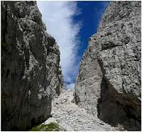
Then the hardest part of the route starts. You're already much tired from the ups and downs and you have to go up for 500 m on a very steep and strenous ravine called Lavaron de la Crete ( the ravine of Creta Grauzaria ) that will take you to the notch called "Il Portonat" ( 1860 m, 1 hour and 45 minutes from the end of the ferrata ). Be careful because also on this ravine the track is not clear and sometimes the old marked path it's not the best option.
 "Il Portonat"
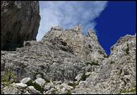 "Lavaron de la Crete"
Once arrived at the notch your energies will be almost over but the climb to the summit ( see Vid's description of the normal route ) of the mountain it's short and not much hard. ( 2065 m, 45 minutes ). The panorama is very nice to all directions, but in particular to the Julians.
The descent is much shorter and less hard then the ascent, although the upper part of the ravine that goes down from the notch is very steep and not much enjoyable. Take the path n°444 to Rifugio Grauzaria and then just before the hut turn right and go towards Val Aupa. After a while you'll meet the first part of the route that will take you to the car in half an hour or so ( 2 hours from "il Portonat").
