
-
 6181 Hits
-
 71.06% Score
-
 1 Votes
|
|
Route |
|---|---|
|
|
46.35360°N / 11.74390°E |
|
|
Easy Ferrata |
|
|
Less than two hours |
|
|
Walk-Up |
|
|
Approach
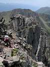
Western approachTake the Lusia cabin lift and cable car from Moena. From the upper station head down the ski run towards passo di Lusia (alternatively take trail no 623 from Moena (600m of elevation gain) which also heads for Passo di Lusia. At the Passo turn east on trail 633 and enter the "Parco Naturale Paneveggio - Pale di San Martino". The trail heads for Forca di Lusia from where you get the first view of the Gronton western ridge and Cima Bocche (see large pic on the main page).
Head down towards Lago Lusia Inferiore and Bivacco Sandro Redolf, which is located on the western shore of the lake. From the Bivacco turn north into a pass (sometimes also called Forca di Lusia). The Sentiero Attrezzato del Gronton starts from this pass.
Eastern approach
Start from Passo San Pellegrino from which you take Sentiero della Pace (no. 628) which leads to Forca di Iuribrutto between the two highest peaks of the Bocche Group, Cima Iuribrutto an Cima Bocche. In the Forca turn west (stil 628) to head for the Cima Bocche Summit. Head down from the summit towards Forca di Bocche, where the Sentiero Attrezzato del Gronto has its eastern end.
Statistics

- Start altitude: 2543m
- Summit altitude: 2622m
- Prevailing exposition: north
- Type: 1h on exposed ledges
- Protection: all exposed places are beautifully secured by cables
 |  |  |  |
Route description
I describe the route from east to west like I have done it though the regular direction is from west to east.Forca di Bocche has an old WW I position and trenches which lead directly in the direction of the Sentiero Attrezzato del Gronton. You can see the direction of the route from the pass it zigzags very steeply up the Gronton slopes. At this point it is a meadow trail but that ends once you obtain the ridge.
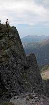
The Gronton Summit is located 50m to the north of the place where you meet the ridge. The Sentiero Attrezzato rather heads westwards always following the northern side of the Gronton west ridge. For most of the time the trail leads along about 10 - 20m below the ridge but in places you have to decend into the Gronton North Face which then is traversed on beautifully exposed ledges.
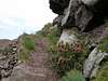
Over time you lose in elevation as the western ridge drops towards Forca di Lusia and Lago di Lusia Inferiore. The exposure drops too and in the end you are on a normal ledge trail. On the other side of Forca Lusia you can see a similar trail traversing the Cima Lusia north face. I assume that this is a WW I trail too, but out of use nowadays. Try to explore it if you have the time.
 |  |  |  |  |