
|
|
Mountain/Rock |
|---|---|
|
|
38.11889°N / 128.46555°E |
|
|
Hiking, Mountaineering, Trad Climbing |
|
|
Summer, Fall, Winter |
|
|
5604 ft / 1708 m |
|
|
Overview
Seoraksan, or Mt. Seorak, is located in the northern portion of the Taebaek Mountain Range in the northeast corner of South Korea. It is the third highest mountain in South Korea, and is considered by many to be its most beautiful. Like the famed Geumgang Mountain across the border in North Korea, it is composed of a fantastic array of rock towers, waterfalls, and some 28 major peaks, the highest of which is Daechongbong Peak (1,708 meters, 5604’). Below the peaks there are gorgeous hardwood forests rising above crystal clear cascades and pools of water. Although not widely known in the West, it is an extremely popular mountain in Korea and on any summer day one can expect to meet hundreds or thousands of people hiking its trails. The 2018 Winter Olympics will take place close to the mountain within Gangwon Province.
Seoraksan National Park


The unique beauty and ecological significance of the region has been long recognized. In 1965, the region was declared a national monument by the Korean government and in 1970 it was converted into a national park. In the intervening years, the size of the park has been expanded a few times so that it now includes some 398 km2 of area. Furthermore, in 1982, Seoraksan was designated as a UNESCO Biosphere Protection District. Although it was nominated to be a UNESCO World Heritage Site in the 1990’s that designation is still pending. The park and mountain are often divided into three regions: the spectacular Oeseorak (outer), Naeseorak (inner), and South Seorak. Perhaps counter intuitively, Outer Seorak is the eastern region close to the coast (farther from Seoul). It contains the steepest terrain and is the place with the highest concentration of sights that tourists and hikers flock to. Inner Seorak is found in the western region of the park that is closer to Seoul, and has less precipitous but heavily forested slopes that are beautiful in a more subtle way.
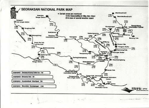 Korea National Parks Map of Seoraksan Park
Some useful contacts include:
Seoraksan National Park webpage
List of ranger stations, information centers, parking lot, shelters and rest areas, and the campsite. Each of the above includes a phone number and address.
Fees for parking, camping, shelters, etc.
Information or reservations for cabins and shelters.
Recomended Hikes
Contact email: webmaster@knps.or.kr
Getting There
Biseondae
Seoraksan can be reached in approximately three hours of driving from Seoul along the Yongdong highway (road 50). Alternately, it is possible to take an express bus from the Gangnam Express Bus Termial in Seoul to Sokcho City. These busses leave approximately every 30 minutes and cost roughly 17,000 won for a one way ticket. From Sokcho City, take the number 7 bus to the Park Villiage (Seorak-dong) and then the gates of the park itself in approximately half an hour at a cost of 1000 won. It is also possible to take a taxi from Sokcho City to the park, and although this is more costly, prices are low compared to those found in many American cities. As of 2011, 1000 won was about $1.
Red Tape
There is a nominal entry fee of several thousand won to enter the park. As noted in the rock climbing section, you must get permission to carry out this activity. There are a number of areas detailed here that are closed to public access as well as the possibility for seasonal closures due to factors such as fire danger. Camping costs approximately 1000 to 2000 won and staying at one of the several mountain huts is also possible at a cost of roughly 7000 won. If you need money, there are a number of ATM’s in the vicinity of the park. Additionally, money can be exchanged in some of the fancier hotels and at banks in Seoul and Sokcho City.
Geology
The region contains largely Mesozoic granite and granodiorite. More detailed information can be found here.
Things to do around Seoraksan
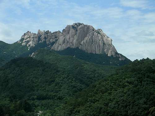
Summit Stretch of Gwongeumseong. Photo by Julie Cassady
The most dramatic scenery in the park is found on the eastern side, which is also the area that most tourists and hikers visit. Consequently, most of the activities listed below are found in this (Outer Seorak) portion of the park, and are accessed from the Seorakdong Information Center area.
Take the Cable Car to Gwongeumseong! This spectacular peak lords over the Cheongbuldong Valley directly adjacent to the Seorakdong Information Center. The tram, which costs about 7000 won and runs from about 7:00 AM to 6:00 PM, whisks you up to the former site of castle that was built some 800 years ago. Once there, if weather permits, you get spectacular views of the East Sea. By hiking and then scrambling some (3rd class with a rope there for aid) you can reach the summit of the peak where the view opens in all directions. This is well worth the effort! While the cable car is ascending, it is clear that there was once a path directly up the line of the cables which angles slightly left near the top. However, this appears to be currently closed for hiking.

Hike to Biryeong Falls: This hike is about 2.4 km in each direction and starts at the Biryonggyo Bridge just east of the cable car station. The initial half of the hike is mostly level and traverses east through beautiful forests and past a few vendors trying to sell you food and such. The last kilometer turns south and winds past a series of wonderful cascades and waterfalls finally arriving at the lovely Biryeong Falls.
Visit an ancient temple and much newer statue of Buddha: A very short walk will allow you to visit what is reputedly one of the oldest Buddhist temples in existence.

Sinheungsa
From the park entrance, hike several hundred meters past the cable car station up the valley where the large Buddha will soon be visible on the right. Shortly thereafter, one can cross any of three bridges and arrive at the Sinheungsa Temple which was originally built in the year 652. Due to several fires over the years, the current buildings were constructed considerably more recently but are quite extraordinary nevertheless. The temple of Baekdamsa is also accessable from the western portion of the park and is near the Baekdam Information Center.
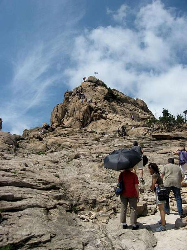
Rock a giant boulder and then ascend a huge stairway to the summit region of Ulsanbawi Rock: This hike is about 4 km in each direction and starts by hiking to Sinheungsa Temple. From there, hike north up a well travelled path for a little over 2 km to Heundeulbawi Rock which is a large boulder resting on a much larger stone opposite a beautiful shrine. If you push firmly on the boulder in the down-valley direction it is possible to make the entire thing rock back and forth and give you a sense of being very strong. From here, you can continue up the trail for another kilometer to the top region of the mighty Ulsanbawi Rock. This portion of the trail is largely stairs and leads to a spectacular view in all directions! There is an extensive series of pictures showing this hike posted online by "PMC" that are interesting to check out if you are contemplating the hike or want to get a feel for it without travelling to Korea.
Visit a shrine in a cave on a cliff:

Geumganggul Cave

Geumganggul Cave trail
From close to the Sinheungsa Temple, one can continue west up the main watershed to the spectacular Biseondae Rock which thrusts directly up for hundreds of meters from the pools and cascades of the river below. From here, continue only about 0.6 kilometers of extremely steep hiking west and north to reach the cave and its shrine. Like Ulsanbawi, this involves climbing steep stairs that angle up a cliff. The view from the cave entrance is magnificent. This hike is about 3 kilometers in each direction from the park entrance.
Climb Daecheongbong Peak:

Daechenongbong

Daecheongbong
This is the highest point of Mt. Seorak. Like Fujisan across the waters in Japan, the sunrises are a treasured site. From Biseondae Rock, take the trail south that climbs up the beautiful Cheonbuidong Valley past several waterfalls. After the last of these, the trail climbs steeply west to a ridge with the Huiungak Shelter. The total distance from Biseondae to the shelter is 5.5 kilometers. From here, the trail becomes extremely steep eventually reaching a ridge above the Socheong Shelter after 1.3 kilometers. Another 1.2 kilometers of hiking along ridges and past yet another shelter leads to the highest summit of Seoraksan where magnificent views await if it is clear! The total round trip hike from the park entrance to the summit and back is approximately 20 kilometers on frequently rough trail. There is a much shorter approach to Daecheongbong Peak from the south from the Nemseorak Information Center. This climbs past Seorak Falls and involves approximately 10 kilometers of hiking round trip.
Rockclimbing
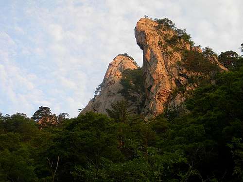
Ulsanbawi
There are boundless cliffs and crags all over the Seoraksan region, many of which are composed of beautiful granite. Although there does not seem to be much information (at least in English) regarding climbs on the mountain, several thousand people climb at Seoraksan during each year. Some of the favorite areas include Janggunbong, Cheonhwadae, and Jeokbyeok. It is worth noting that climbing is restricted at most crags and cliffs (excepting Agulbawi) from roughly March 15 to May 15th due to possible fire danger). You are also required to contact the park prior to climbing and providing them with information including the names and identification for the group, the region and route that you intend to climb, and a timetable for when you are planning to leave and when you plan to return. This has to be done either at least three days prior to your climb to pick up the permit the day before, or on the day of the climb if you don’t plan on leaving until after the offices open at 8:00 in the morning. Joe Park has included information about obtaining a permit here. The documents needed in the application were recently posted on line in English by a considerate climber. An English version of the Seorak Park page is accessable here. There is a nice article describing climbing in Seoraksan here.
Given the vast number of waterfalls, this is also an ideal location for ice climbing, with the three hundred meter TowuangSeong, located an hours walk past Biryeong Falls, being a favorite.
Climate and Weather
Generally, it is extremely cold in mid winter at Seoraksan. During the early spring there is a dry season which often causes the closure of a number of trails and climbing routes. After a rainy spell in late May and June, the weather usually turns drier and hotter for late summer, although the possibility for a typhoon increases... Many people enjoy going to Seoraksan in the fall to witness the beautiful fall colors.
Several sites, including this one, give weather forecasts for the mountain.
External Links
The following websites have information regarding Seoraksan. I used many of them in obtaining information for this page:
Seoraksan Park has a page that can be accessed here. This includes a bevy of information including a map of how to approach the park from Sokcho, entry, camping and hut names and prices, suggested hikes and much more.
Wikipedia's Soraksan page.
Lonely Planet provides information on the region
here.
Republic of Korea's Ministry of Environment page on Seoraksan.
Fees and Closures >This highly useful site tells of seasonal closures, areas of the park that are restricted or closed to travel, various fees, and travel information to the park.
>This site includes extensive information on fees including entry fees, camping fees, lodging fees, and even fees needed to film a movie in the park.
Frommers has extensive information on the park here.
There is at least one commercial guide for rockclimbing at Seoraksan. You can use this link to access their webpage.
A hiker posted a You Tube video with scenes from Geumganggul Cave and Biryeong Falls. This video includes some footage of climbers rapelling down a cliff as well.
Korea's Tourism Organization has a site that includes a number of hikes, including some of those that I have listed above as well as others. In addition there are some fabulous pictures of the peaks.
Thanks
I would like to thank Julie Cassady for letting me use two of her pictures for this website.