
-
 5358 Hits
-
 73.06% Score
-
 3 Votes
|
|
Route |
|---|---|
|
|
38.88328°N / 106.94362°W |
|
|
Hiking |
|
|
Spring, Summer, Fall |
|
|
Most of a day |
|
|
YDS Class 2 |
|
|
I |
|
|
Overview
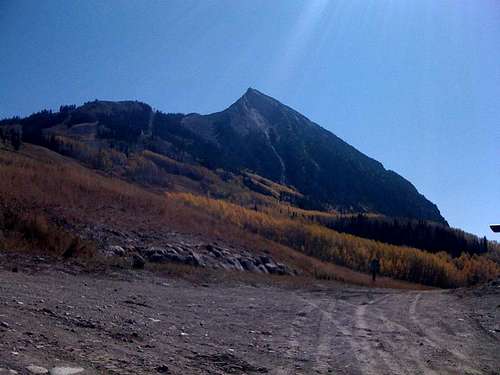 Start of the route
This is the most popular way to summit the mountain according to some locals. There is a mountaineer's route somewhere, but I am unsure where it is located. So anyway, this entire hike is on the a service road on which only service vehicles are permitted. The last half mile to the summit is not on the service road. The service road ends and you follow a good trail to the summit. Mountain bikers are urged to take this route. The summit of this mountain is basically an overlook on the entire end of the Elk Range including most of the Ruby Range. If you look straight down, you will see the town of Crested Butte. However, when you look across you can see Mount Emmons including the Ruby Range and Gothic. It may be a good idea to attempt this mountain on a day with 0% or 10% precipitation. As explained in the main overview page, this mountain is one of the most popular landmarks and summiting it should be considered a great accomplishment.
Getting There
Crested Butte is a small town located in Gunnison County. It is just miles from Aspen and Gunnison, CO.From Aspen you could go over Independence Pass to Twin Lakes, then make a right to Buena Vista. From there go over Monarch Pass (paved) to Gunnison. From there, go North for about 50 miles or so to Crested Butte. Or if you want a more scenic trip, take a short cut.
From Buena Vista go to main street and get onto Cottonwood Pass. Go down a dirt 2WD road to Taylor Park. From there make a left and go through the Taylor Canyon. Right after your out of the canyon, get onto a dirt 2WD road called "Jack's Cabin Cut-Off" (2WD). Once you get to a paved road make a right into Crested Butte. From here go to Mount Crested Butte and find the service road to the right, near the cut-off for Gothic, from here, you hike begins.
Route Description
 First rock slope
To your right is a picture on the first slope to the summit.
Now, once you accomplish that slope, a false summit comes in view and after you get over that, the real summit is in view. To the right, you will see what it looks like for the next 25 feet to the summit.
 Final 25 feet to the summit
Here is a picture of what it looks like on the summit.
 Summit
There are a few crosses and random objects on top, including a box with a scroll of the people who climbed the mountain in it.
Round-trip length: 11 Miles
Variation
Here is a variation if you want more of a challange. It cuts out 6 miles round-trip:Start at the service road but get off of the road and follow the Red Lady Express lift untill you see a sign for the Avery bike trail. You should be at a Service Road/Avery junction. Make a right here and follow the service road untill you see a slope with a ski run ontop. Head up the slope. Once on the top of the hill you should bear to the right to get to the Twister lift. From here go up another small hill and connect with the service road and follow that for about 200 yards until you get to the Silver Queen lift. Now follow the summit trail to the left to the summit.
w/ this varation your RT is 8 miles