
-
 6434 Hits
-
 85.35% Score
-
 20 Votes
|
|
Mountain/Rock |
|---|---|
|
|
34.09235°N / 116.15308°W |
|
|
Riverside |
|
|
Trad Climbing, Sport Climbing, Toprope |
|
|
Spring, Summer, Fall, Winter |
|
|
3136 ft / 956 m |
|
|
Overview

Short Wall is the name of a rock formation in the Indian Cove area of Joshua Tree National Park, California.
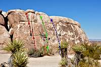
Short Wall could have been considered as a part of its close neighbor Feudal Wall except that they are separated from each other by a sandy corridor. The two formations are very similar in the quality of their cracks and faces except the fact that Short Wall is a lot shorter. This formations sports two distinct sections, the left side which is taller of the two at around forty five feet, and the right side which is only thirty feet high, hence the name. The majority of the more difficult routes are located on the left side and the majority of the easier routes are on the right, shorter side.
I cannot think of another formation in the Indian Cove area with greater base as the Short Wall's. The base is long, wide, flat with no rocks or bushes. In fact, for many decades visitors could drive all the way up and park their cars right in front of the rock. At some point in time, the park service did a great thing by placing large boulders on the entrance to this area, no more cars, tents or sleeping bags on the base of the routes here. Thank you park service!
Select Routes

Left side
Right side

Class in session
Short Wall has traditionally been an ideal sight for climbing classes, private climbing clubs and groups. The right side with all of its easy cracks is a perfect location for beginners to learn jamming techniques. The approach to the top to set up top-rope could not be easier. Go around the formation from the right side to reach the sandy corridor separating this rock from Feudal Wall and scramble up and around boulders to reach the top of Short Wall.
The left side, however, is somewhat different in that it offers a number of more difficult routes to mid 5.10s. One of the face routes on the left side is "Double Trouble, 10a" and its first ascent goes to my good friends Herb and Eve Laeger. Unfortunately, at some point in time, the bolts protecting this route were chopped rendering it into only a top-rope problem. In addition to the list of select routes in this page, there are many more face routes that climb in between the crack systems. You will also find several face routes to the right of the last crack, "S.O.B." on the right side of this formation.
List of the select Routes
select routes of Short Wall | |
| A | Double Trouble, 10a, Top-Rope |
| B | Mad Race, 5.4, Standard Rack, wide pro |
| C | Bombay, 5.8, standard Rack |
| D | Calcutta, 5.7, standard rack |
| E | Double Cracks, 5.3, standard Rack |
| F | Toe Jam Express, 5.3, Standard Rack |
| G | S.O.B. 5.6, Standard Rack, wide pro |
Getting There
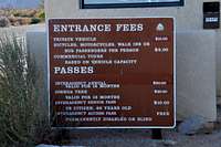
Entrance to the park/Ranger Station
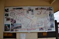
Indian Cove is located roughly nine miles east of the town of Joshua Tree on highway 62. The sign directing you to Indan Cove is obvious. Turn right, going south, here. If you go as far the town of 29 Palms, you have gone too far. It’s about three miles from here to Indian Cove Campground. Drive south on this road to a ranger station and the enterance to the park. You will be checked at the gate for your America The Beautiful card, or will be charged an enterance fee. Driving past the gate will bring you to the Indian Cove Campground. Entering the Indian Cove Campground, you pass by Pixie Rock to your right and The Billboard Buttress to your left. Turning left at the fork and looking further down, you will see a large formation on the north side of the road above a small canyon. This is Feudal Wall. Park here and walk or drive a bit further down the same road. Short Wall will be seen to your left. The parking here is very limited, but other parking possibilities aren't too far.
Camping, Noise Considerations, Environmental Concerns,
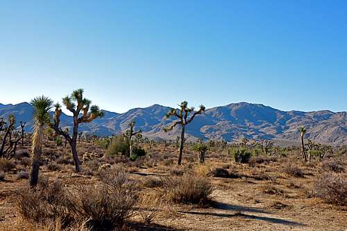
Typical Joshua Tree landscape
Please tread lightly. The Access Fund has gone to great lengths posting trail marker for approaches to many of the more popular crags. Do your best to stay on these trails, and where you are forced to use a different path, choose the ones that rain can mend in time. Drainages make for good trails where there are no established trails.
Avoid stepping on native and fragile plants, and do not feed the coyotes. Coyotes are very much used to people and often hang around picnic areas and camp grounds in hopes of getting a hand out. It’s better to let them live their natural life.
Camping

Joshua Tree Camping
Noise considerations
When you are camping with friends and sitting around the fire, it is easy to forget that there are other people trying to sleep in the nearby campsites. It is important to put yourself in their shoes. Keep the noise and music to a minimum and certainly not too much past 10 p.m. Your neighbors will smile at you in the morning instead of giving you dirty looks.