
-
 20731 Hits
-
 87.2% Score
-
 24 Votes
|
|
Mountain/Rock |
|---|---|
|
|
42.24172°N / 8.70156°E |
|
|
Hiking |
|
|
Spring, Summer, Fall, Winter |
|
|
4245 ft / 1294 m |
|
|
Overview
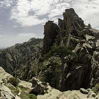
 Capo d'Orto seen from the upper part of the gully route Capo d'Orto seen from the upper part of the gully route |
At only 1294m Capo d'Orto certainly is not one of the big mountains of the world. On the other hand, these roughly 1300m rise directly above Golfe de Porto on the east coast of Corsica so that reaching the summit is no little undertaking, even though you can get there by marked hiking trails. And from the top, views down to the Golfe are clearly exceptional. Moreover, Capo d'Orto is the second highest summit (after Capo di u Vitullu) of the Calenche de Piana, one of the most bizzare places on this planet, thanks to the strange rock formations, called Tafonis (see section below), which you can find there. Thus, hiking towards the summit of Capo d'Orto can turn into a wonderful experience.
 |  |  |
Capo d'Orto is made up from red granite like the rest of the Calenche. It stands out above Gorge de Spelunca to the south of the little town of Porto, from which it rises with a vertical north face for roughly 1000m. To its west it is connected to a high plateau, across which the normal hiking route runs but on the three other sides you find drops of several hundred metres. There are several summits, the main ones of which encircle a profound chasm to the south of the main summit. Additionally to the north you find the Tre Signori, big towers which stand a little apart bbut which turn out to be one of the main photographic attractions on the summit.
 |  |  |
While there are certainly good climbing possibilities on the perfect granite rock thw dense Macchia brushwork spoils everything. It is tough to get to the base of the mountain unless you use the hiking trails from the west. These start at the village Piana and criss-cross the Calenche, many of them offering to take you all the way to Capo d'Orto. In the end they recombine but still leave the option for two routes in the last section. One leads across the plateau directly towards the summit, where the summit block has to be climbed by an easy rock section (UIAA I). The second heads for Foce d'Orto, the saddle between Capo d'Orto and Capu di u Vitullu. From here an extremely steep gully awaits you, taking you across UIAA II terrain to a notch above the chasm mentined above. From there you have to circle the south summit to reach the aforementioned UIAA I section on the normal route. Route finding is rather difficult here.
One last note: the Calenche de Piana is one of the major attractions on Corsica all for tourists, hikers and for serious climbers. Reaching it, though generally easy, turns difficult by the very narrow roads on which you find lots of coaches. Most visitors stay near the road (between Piana and Porto), enjoying the short easy hikes there. However, there are also a multitude of climbing routes in the area (also most of them close to the road) and very interesting long hikes like the one to Capo d'Ortu or its brother Capo di u Vitullu. The best place to park for longer activities is the lot for the abandoned sports field of Piana, from where hiking paths take you to all the desirable destinations. The sports field is close to the road, in a bend, where it enters the Calenche from the north.
Calenche de Piana
 Summit View across the Calenche
As said above, the Calenche de Piana is THE major attraction in the west of Corsica. The attractions of the region are the bizarre rocks that compose the Calenche. The longer you look the more you wonder how this whole area has been formed (see section below). There is the obvious legend that some human challenged the Devil - and won. The Devil - being very angry - tortured the country instead - and this is how the Calenche came into being.
The Calenche de Piana continues down to sea level - and below. I've been told that it is very worthwhile to ask one of the local fishermen to show the gorges, bays and grottos to you that upen up just above and below the surface of the sea. I haven't been on one of these cruises but know people who have...
Tafoni - the typical erosion structures of Corsica and Sardinia
 Sentinel above the Calenche
The Calenche de Piana is composed of a large variety of strange looking rock formations, all having been formed by ages of erosion. Similar structures can be seen on Sardinia and in different parts of the world as well. In Corsica this kind of erosion is called Tafoni, derived from the Corsican word tafonare for "perforate". In most of the cases Tafoni have been hollowed out in a semi circular fashion.
 |  |  |
The actual process is a combination of physical and chemical erosion forms. Through capillary forces moisture within the rock is allowed to climb to the surface of the rock. Since the fluids dissolve part or the inner rock structure they can deposit these minerals on the surface which form a very hard but also very thin outside crust. In the course of time the effect weakens (or softens) the inner rock structure while the outside crust gets harder and harder.
 |  |  |
Once the crust (mainly iron and manganese oxide) is broken and wind and rain can erode the inner and softer rock, the latter is eaten away rapidly (at least on a geological scale) like the innards of your regular breakfast egg. Since moisture will stay longer and since Evaporation is occurring less on the shadowy northern parts of the rocks the crusts there remain very thin and can get broken much more easily.
The whole Tafoni process takes very long and today's Tafonis have been being created since the last ice ages.
Getting There
 Summit View across the Spelunca Gorge towards Paglia Orba
Corsica can be reached by ferry or by plane. Major gateways are Ajaccio in the west and Bastia in the north. Usually both ferries and planes start from Marseille or Nice on the Côte d'Azur.
Capu d'Orto is located a little south of Porto, the main town in the northwest of Corsica. You'll reach Porto from Ajaccio via the coastal highway D81. It is not very far but the highway winds around and over a lot of bays and passes. Shortly before Porto you have to go through the Calenche. The road is VERY narrow, and since the Calenche is a major tourist attraction lots of coaches use it. So it can take up to an hour to drive the 5km between Piana and Porto! Again, you might want to start early. The various trailheads are all on this road.
From Bastia you need to take RN 193. At Francardo you turn right onto D84 which will lead you through the famous gorge of Scala Sta. Regina. On your right hand side you will soon see Monte Cinto and Paglia Orba before you head upwards to the pass of Col de Vergio (1477m). From here you can already see Porto as well as Capo d'Orto though the actual drive will take you about an hour due to the winding narrow road.
Red Tape
 Podarcis tiliguerta, Thyrrenean Wall Lizard on Capo d'Orto
There are no limitations within the area. Hiking and parking is free. Around the trailheads in the Calenche there are only a few parking places so you might want to start from the village of Piana (sports field).
When To Climb
Capo d'Orto can be climbed all year round. You'll encounter snow in winter but the ascent is rather easy so it shouldn't pose any problem. The best season is spring, however. The blossoming machia is a sight to see and smell. You'll find quite a lot of spices, mainly sage and thyme.Accommodation
 Golfe de Porto
Accommodation has changed a lot during the last ten years. Today it is possible to book holiday homes, hotel rooms or apartments from any travel office. Also, there are a number of sites on the internet dedicated to Corsica accommodation. You can get apartments and holiday homes in any of the villages along the coasts.
There's a campground at sea level at the beach of Porto. Other accomodation can be found in Porto, Piana or Evisa (or any of the smaller villages). Most appartments and hotels are closed out of season, however. I am not aware that free camping is restricted. But due to the proximity of Porto it is not really neccessary.
Weather Conditions
Maps & Books
Maps
- Porto / Calenche de Piana
1 : 25.000
Carte de Randonnée 4150 OT
ISBN: 2-85595-165-8
Books
There are quite naturally quite a number of guidebooks, most of them in French. I found the following as good as could be expected:
- Corsica (Corse / Korsika)
Klaus Wolfsperger
Rother Verlag
ISBN: 978-3-7633-4819-0 (English)
ISBN: 978-3-7633-4907-4 (French)
ISBN: 978-3-7633-4280-8 (German)